Weather
Stormy and Rainy Week Ahead for Chicago Area
There is a chance for rain or storms every day this week except for Wednesday. Warmer temps are in the forecast for Monday and Tuesday.


Showers and thunderstorms are expected across the Chicago area Sunday night with more chances for storms on Monday. The start of the week will be warm but rain is in the forecast for every day this work week except for Wednesday.
The thunderstorms on Sunday are expected to develop across portions of Iowa and Missouri Sunday evening and may track into portions of northern Illinois later this evening and overnight, according to the National Weather Service. While the threat for severe thunderstorms is not particularly high, there is a some potential that a couple storms could produce quarter-sized hail.
The greatest threat lies southwest of the Chicago metropolitan area in a line that runs south and west of Rockford to Joliet to Paxton. Elsewhere, showers and a few rumbles of thunder are possible, according to weather officials. Additional showers and thunderstorms are possible on Monday.
Find out what's happening in Chicagofor free with the latest updates from Patch.
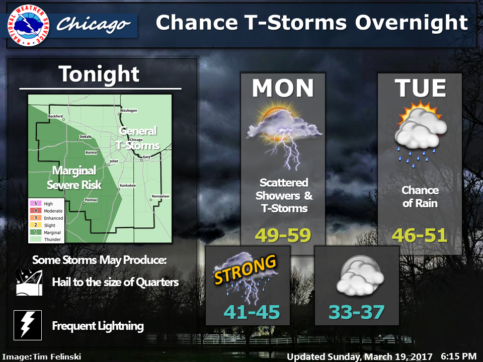
Warmer temps are also expected for the start of the week. High temperatures between 49 and 59 degrees are expected on Monday and high temps between 46 and 51 degrees are expected. More rain is expected on Tuesday.
Temps will dip back into the 30s for Wednesday but should warm again by Friday when high temps could reach into the 60s. Wednesday is expected to be dry but showers are possible during the day on Thursday, Friday and Saturday.
Find out what's happening in Chicagofor free with the latest updates from Patch.
Here is a more detailed look at the weather forecast for the Chicago area this week:
- Sunday Night: Partly cloudy until early morning then becoming cloudy. Light showers likely and a chance of thunderstorms after midnight. Lows in the lower 40s. South winds 10 to 15 mph. Chance of precipitation 70 percent.
- Monday: Cloudy. Light showers likely and a chance of thunderstorms in the morning, then a chance of light showers in the afternoon. Highs in the lower 50s. Southwest winds 5 to 10 mph in the morning shifting to the north 10 to 15 mph in the afternoon. Chance of precipitation 70 percent.
- Monday Night: Mostly cloudy. Lows in the mid 30s. North winds 10 to 15 mph.
- Tuesday: Mostly cloudy with a 30 percent chance of light showers. Highs in the upper 40s. North winds 5 to 10 mph.
- Tuesday Night: Partly cloudy. Lows in the mid 20s. Northeast winds 10 to 20 mph.
- Wednesday: Partly cloudy in the morning then becoming mostly sunny. Highs in the mid 30s.
- Wednesday Night: Partly cloudy. Lows in the upper 20s.
- Thursday: Mostly cloudy. A 40 percent chance of rain showers in the afternoon. Highs in the upper 40s.
- Thursday Night: Cloudy. Showers likely in the evening, then a chance of showers after midnight. Lows in the lower 40s. Then temperatures becoming steady or slowly rising. Chance of precipitation 60 percent.
- Friday: Windy. Mostly cloudy. Chance of showers. Highs in the lower 60s. Chance of precipitation 30 percent.
- Friday Night: Showers likely. Lows in the lower 40s. Chance of precipitation 70 percent.
- Saturday: Mostly cloudy. Showers likely in the morning, then a chance of showers in the afternoon. Highs in the lower 50s. Chance of precipitation 70 percent.
Get more local news delivered straight to your inbox. Sign up for free Patch newsletters and alerts.

