Weather
Temps in 70s, Showers And Thunderstorms Possible Sunday Night
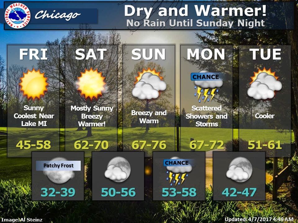
Here is a look at the weather forecast for the Chicago area for the upcoming weekend.


After a week of clouds and rain, it's looking like sunshine and warmth are finally in the forecast for the Chicago area.
On Friday, sunshine, dry weather and mild temperatures are on tap. High temps will reach between 45 and 58 degrees with the cooler temps expected along Lake Michigan, according to the National Weather Service.
Even warmer weather is in store for the weekend.
Find out what's happening in Chicagofor free with the latest updates from Patch.
On Saturday, high temps between 65 and 70 degrees are expected, and on Sunday, expect high temps between 70 and 75 degrees.
There is a chance for showers and thunderstorms on Sunday night as a slow-moving cold front approaches. The scattered thunderstorms are possible mainly after midnight on Sunday night with some storms expected again on Monday afternoon and evening. A few of these storms could be severe with large hail and damaging wind gusts.
Find out what's happening in Chicagofor free with the latest updates from Patch.
Meanwhile, a flood warning remains in effect through p.m. Saturday for the following rivers in the area: the Des Plaines River at Lincolnshire affecting Lake County, the Des Plaines River near Des Plaines affecting Cook County, Des Plaines River near Russell affecting Lake County and the Des Plaines River near Gurnee affecting Lake County. Those who encounter a flooded roadway are encouraged to turn around and find an alternate route.
Meanwhile, a flood advisory remains in effect through 7:30 p.m. Friday for the Des Plaines River at River Forest affecting Cook County, the DuPage River near Plainfield affecting Will County, the North Branch Chicago River at Chicago Albany Ave affecting Cook County and the Kankakee River near Wilmington affecting Grundy and Will counties.
Here is a more detailed look at the forecast for the coming days:
- FRIDAY: Sunny. Highs in the mid 50s inland...but only in the upper 40s near the lake. North winds 10 to 20 mph.
- FRIDAY NIGHT: Mostly clear. Patchy frost after midnight. Lows in the upper 30s. Southwest winds 5 to 10 mph.
- SATURDAY: Mostly sunny. Warmer. Highs in the mid 60s. South winds 10 to 20 mph. Gusts up to 30 mph in the afternoon.
- SATURDAY NIGHT: Partly cloudy. Mild. Lows in the mid 50s. South winds 10 to 20 mph.
- SUNDAY: Mostly cloudy. Warm. Highs in the lower 70s. South winds 10 to 20 mph with gusts up to 30 mph.
- SUNDAY NIGHT: Mostly cloudy. Slight chance of showers in the evening, then a chance of showers and a slight chance of thunderstorms after midnight. Lows in the upper 50s. Chance of precipitation 30 percent.
- MONDAY: Partly sunny with a 30 percent chance of showers and thunderstorms. Highs in the upper 60s.
- MONDAY NIGHT: Partly cloudy. Lows in the mid 40s.
Get more local news delivered straight to your inbox. Sign up for free Patch newsletters and alerts.

