Weather
Temps in the 70s Thursday and Then Snow Possible Friday, Saturday
Temperatures could drop off more then 30 degrees in 24 hours as a cold front enters the Chicago area later on Friday.

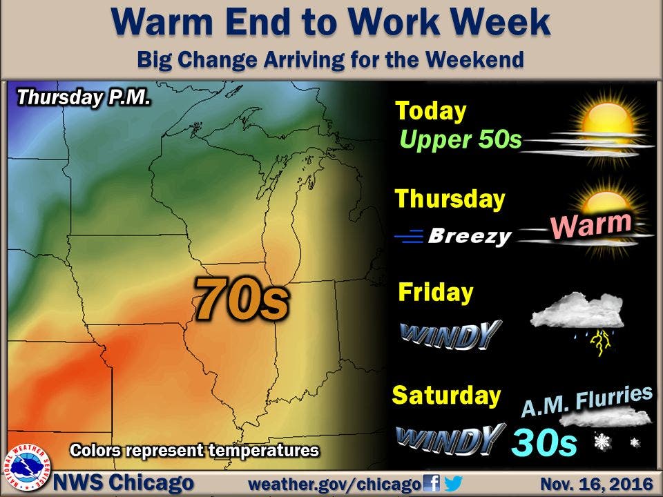
With sunshine and temperatures way above average for this time of year, including highs in the 70s Thursday, it’s hard to believe by late Friday the Chicago area could see its first snowfall.
The National Weather Service is predicting snow flurries or even light snow showers late Friday night and early Saturday morning. But before then, temps will soar. On Wednesday, temperatures near 60 degrees are expected for the Chicago area and on Thursday, those temps could reach near-record territory with highs likely in the lower to mid-70s.
Highs will reach the mid-60s on Friday but later in the day, those temps will drop off sharply. That cold front is expected to bring showers and even possibly thunderstorms in the evening. There is a slight chance of showers and snow showers after midnight with the chance of snow continuing into Saturday morning.
Find out what's happening in Chicagofor free with the latest updates from Patch.
A low in the mid-30s is expected Friday night and high temperatures around 40 are expected Saturday and Sunday.
Here is a more detailed look at the forecast for the coming days:
Find out what's happening in Chicagofor free with the latest updates from Patch.
- Wednesday: Mostly sunny. Patchy fog late in the morning. Highs in the mid 50s. Northeast winds around 5 mph late in the morning becoming east in the afternoon.
- Wednesday Night: Partly cloudy. Lows in the mid 40s. Southeast winds 10 to 15 mph.
- Thursday: Mostly sunny. Near record breaking warmth likely. Highs in the lower 70s. South winds 10 to 20 mph with gusts up to 30 mph.
- Thursday Night: Mostly clear in the evening then becoming partly cloudy. Lows in the mid 50s. South winds 10 to 20 mph. Gusts up to 30 mph in the evening.
- Friday: Mostly cloudy. Showers likely and a chance of thunderstorms in the afternoon. Breezy. Highs in the mid 60s. Then temperatures falling into the upper 50s by evening. Southwest winds 15 to 25 mph with gusts up to 30 mph. Chance of precipitation 60 percent.
- Friday Night: Windy. Mostly cloudy. Chance of rain showers in the evening...then a slight chance of showers and snow showers after midnight. Lows in the mid 30s. Chance of precipitation 30 percent.
- Saturday: Very windy. Cloudy with a 30 percent chance of snow showers and showers in the morning...then partly sunny in the afternoon. Highs around 40.
- Saturday Night: Mostly clear. Lows in the mid 20s in the suburbs...but in the upper 20s downtown.
- Sunday Through Monday: Mostly clear. Highs in the lower 40s. Lows in the mid 20s in the suburbs...but in the upper 20s downtown.
Photo via the National Weather Service
Get more local news delivered straight to your inbox. Sign up for free Patch newsletters and alerts.

