Weather
Week Ahead Weather for Chicago Area: Frost, Temps Near 70, Rain
A look at the Chicago area forecast for the week ahead.


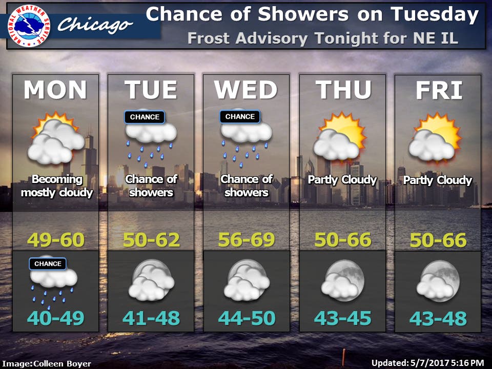
The work week will get off to a very cold start. A frost advisory is in effect starting at midnight and continuing through 6 a.m. Monday for the Chicago area. Low temperatures will reach the low to mid-30s, with widespread frost expected, which means sensitive outdoor plants should be brought inside, according to the National Weather Service.
Temps will warm to a high of 60 for portions of the Chicago area while areas near Lake Michigan will only see temps in the upper 40s to low 50s.There is a chance for rain showers Monday night and during the day on Tuesday.
Temps will again remain lower along the lakefront on Tuesday with high temps reaching between 50 and 62 degrees across the area on. Temperatures should peak on Wednesday near seasonal norms and will be between 56 and 69 degrees. Rain showers are possible Wednesday afternoon.
Find out what's happening in Chicagofor free with the latest updates from Patch.
On Thursday, expect high temps between 50 and 66 degrees and on Friday, temps could reach highs between 50 and 66 degrees. Both Thursday and Friday should be dry with partly cloudy skies.
Here is a more detailed look at the forecast for the coming days:
Find out what's happening in Chicagofor free with the latest updates from Patch.
- SUNDAY NIGHT: Clear. Areas of frost after midnight in the suburbs. lows in the lower 30s in the suburbs...but around 40 downtown. northeast winds 5 to 10 mph.
- MONDAY: Partly cloudy. Highs in the mid 50s inland...but only in the upper 40s near the lake. East winds 10 to 15 mph.
- MONDAY NIGHT: Mostly cloudy. Slight chance of showers in the evening, then a chance of showers and a slight chance of thunderstorms after midnight. Lows in the lower 40s. East winds 5 to 10 mph. Chance of precipitation 30 percent.
- TUESDAY: Mostly cloudy with a 30 percent chance of showers. Highs in the upper 50s inland...but only in the lower 50s near the lake. East winds 5 to 10 mph.
- TUESDAY NIGHT: Partly cloudy. Lows in the mid 40s. Northeast winds 5 to 10 mph.
- WEDNESDAY: Mostly cloudy. A 30 percent chance of showers in the afternoon. Highs in the mid 60s inland...but only in the mid 50s near the lake.
- WEDNESDAY NIGHT: Partly cloudy. A 20 percent chance of showers in the evening. Lows in the mid 40s.
- THURSDAY: Partly cloudy. Highs in the lower 60s inland...but only around 50 near the lake.
- THURSDAY NIGHT THROUGH FRIDAY NIGHT: Partly cloudy. Lows in the mid 40s. Highs in the lower 60s inland...but only around 50 near the lake.
Get more local news delivered straight to your inbox. Sign up for free Patch newsletters and alerts.

