Weather
WEEKEND WEATHER ALERT: Up to 12 Inches of Snow Expected for Chicago Area
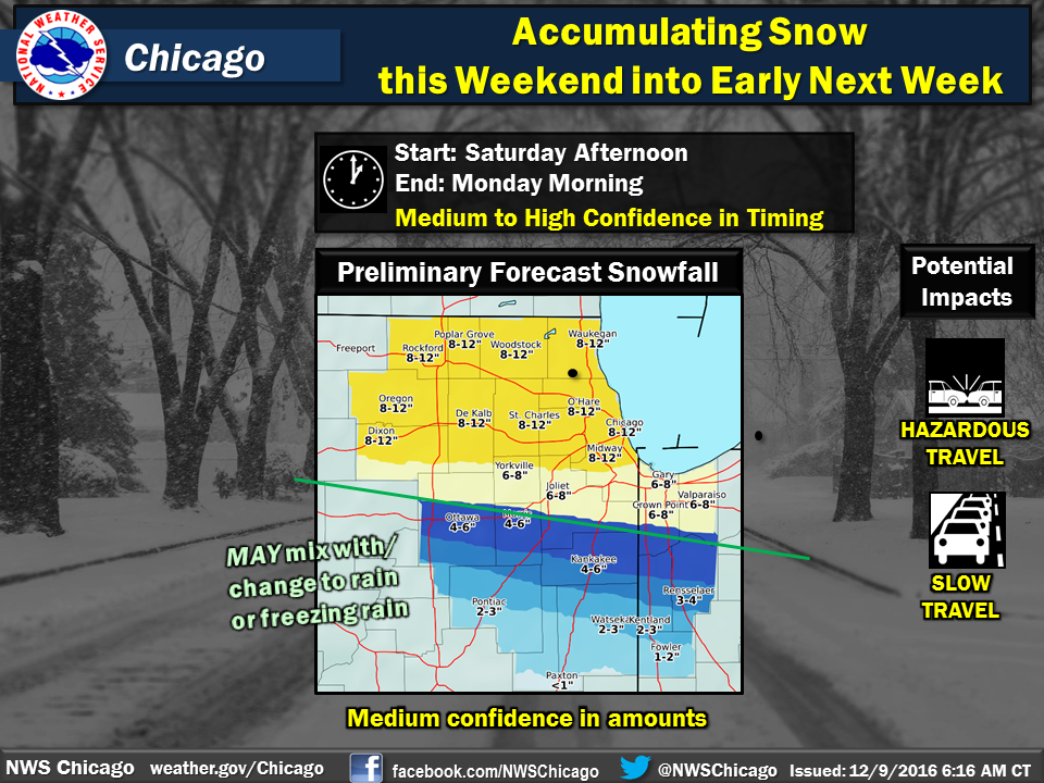
The snowstorm is expected to start Saturday afternoon and continue through Monday morning.


UPDATED AT 10 A.M. SATURDAY: SNOW ACCUMULATION ESTIMATES AND WHEN THE STORM WILL HIT
-----
The Chicago area could see up to 12 inches of snow this weekend.
Find out what's happening in Evanstonfor free with the latest updates from Patch.
The accumulating snow is expected to start Saturday afternoon and continue through Monday morning, according to the National Weather Service. A preliminary forecast calls for 8 to 12 inches of snow for most of the Chicago area during the course of the winter storm.
The snow should taper off Sunday morning before starting back up again on Sunday afternoon and continuing through late Sunday or early Monday morning, Fox 32 News was reporting Friday morning.
Find out what's happening in Evanstonfor free with the latest updates from Patch.
Chicago meteorologist Tom Skilling shared the following information Friday morning regarding the timing of the storm:
Check back to Patch throughout the day and weekend and sign up for our breaking news alerts below to get the latest on the weather.
Here is a more detailed look at the weather forecast for the coming days:
- FRIDAY: Mostly cloudy. Occasional flurries in the morning. Highs in the mid 20s. West winds 10 to 20 mph.
- SATURDAY: Mostly cloudy. A 30 percent chance of light snow in the afternoon. Highs in the lower 20s. Southwest winds 5 to 10 mph.
- SUNDAY: Light snow likely. Several inches of accumulation possible. Highs in the lower 30s. South winds 10 to 20 mph. Chance of precipitation 70 percent.
- MONDAY: Mostly cloudy with a 30 percent chance of light snow. Highs in the lower 30s.
- TUESDAY: Mostly cloudy. Highs in the lower 20s.
- WEDNESDAY: Partly sunny. Highs 11 to 15.
Get more local news delivered straight to your inbox. Sign up for free Patch newsletters and alerts.