Weather
Heavy Rain, Storms, Flooding Possible This Weekend
A look at this weekend's weather forecast for the Chicago area.

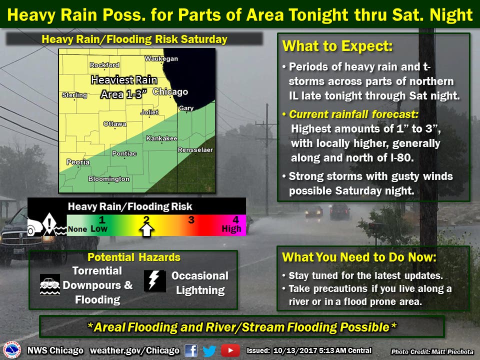
The Chicago area could get hit hard by heavy rains and thunderstorms this weekend. The showers and storms are expected to develop across portions of northern Illinois Friday night. Periods of showers and some storms with heavy rainfall will continue at times on Saturday, according to the National Weather Service.
The period of strong storms, capable of producing damaging wind gusts and very heavy rainfall, will then be possible across portions of northern Illinois Saturday night as a strong cold front shifts across the area. The heavy rainfall could produce up to one to three inches of additional rain across portions of northern Illinois, especially north of I-80.
This in combination with the recent heavy rain may result in rapid rises on area rivers and possible flooding concerns, according to the National Weather Service.
Find out what's happening in Genevafor free with the latest updates from Patch.
(For more information on this and other neighborhood stories, subscribe to Patch to receive daily newsletters and breaking news alerts.)
Above average temperatures are through Saturday for portions of the Chicago area, but more seasonal temps are expected in the days following. High temps between 68 and 75 degrees are in the forecast on Friday while highs between 72 and 81 degrees are expected Saturday.
Find out what's happening in Genevafor free with the latest updates from Patch.
Sunday should be windy and cooler with low temps between the upper 30s and lower 40s. Highs will reach between 57 and 62 degrees across the suburbs.
Temps return to slightly above normal by the middle of next week. Sprawling high pressure will also lead to another dry stretch for most of next week, according to the National Weather Service.
Here is a more detailed look at the forecast for the coming days:
- Friday: Mostly cloudy, with a high near 69. South wind 5 to 10 mph.
- Friday night: A chance of showers and thunderstorms between 10pm and 1am, then showers and possibly a thunderstorm after 1am. Low around 60. East southeast wind around 5 mph. Chance of precipitation is 80%. New rainfall amounts between a quarter and half of an inch possible.
- Saturday: Showers and possibly a thunderstorm. High near 72. South wind 5 to 10 mph. Chance of precipitation is 90%. New rainfall amounts between a half and three quarters of an inch possible.
- Saturday night: Showers and possibly a thunderstorm. Low around 54. South wind 10 to 15 mph becoming west after midnight. Winds could gust as high as 30 mph. Chance of precipitation is 80%.
- Sunday: Partly sunny, with a high near 57. West northwest wind around 15 mph, with gusts as high as 30 mph.
- Sunday Night: Mostly clear, with a low around 41.
- Monday: Sunny, with a high near 61.
- Monday Night: Mostly clear, with a low around 46.
- Tuesday: Sunny, with a high near 66.
- Tuesday Night: Mostly clear, with a low around 49.
- Wednesday: Sunny, with a high near 68.
Get more local news delivered straight to your inbox. Sign up for free Patch newsletters and alerts.