Community Corner
Tornados Spotted West of Chicago Area
At least 10 tornado sitings reported west of the suburbs. Storms with 2-inch hail and 80 mph winds blew though the area.

Strong winds, rain, major cloud-to-ground lightning and tornados swept through northern Illinois on Wednesday night, with twisters spotted in several small communities west of the Chicago area.
The National Weather Service issued a Tornado Watch through 1 a.m. for northern Illinois, including Cook, DeKalb, DuPage, Grundy, Kane, Kankakee, Kendall and Will counties in the Chicago area, but the watches for the most part expired by 10 p.m. as the storm moved eastward.
As many as 3,400 cloud-to-ground lightning strikes were reported in the Chicago area throughout the four-hour storm path.
Find out what's happening in Genevafor free with the latest updates from Patch.
Weather spotters say they saw two tornados on the ground in Earlville, IL, along Route 34 in LaSalle County. That's about 35 miles west of Oswego. The NWS confirmed another tornado northeast of Seneca moving east at 20 mph. ABC Chicago reported that a house collapsed north of Seneca Wednesday night.
A wall cloud was recorded in Amboy, in Lee County, earlier this evening. Another tornado was spotted in Leland, east of Earlville. As many as 10 sitings of tornados have been reported in Lee and LaSalle County as of 9 p.m.
Find out what's happening in Genevafor free with the latest updates from Patch.
The storm reached central and southern Will County between 9 and 10 p.m., according to the Joliet Weather Center, and funnel clouds menaced the Morris area.
The skies along the North Shore were reportedly green as night fell and the storm picked up speed through the region, but most of the active weather was in the south.
NBC Chicago reported a funnel cloud sighting in south suburban Evergreen Park and Harvey, but no tornado touched down in the suburbs. Navy Pier was closed and people were advised to "shelter in place" in that location as the storm entered Chicago before 10 p.m. A soccer match at Soldier Field was suspended and major rainfall flooded the corridors as spectators were kept inside the stadium.
Wednesday's Original Report
A hazardous weather outlook and flash flood watch was issued earlier today for much of northern Illinois, including the Chicago suburbs. The thunderstorms were expected to produce very heavy rain and rainfall rates of up to two inches per hour, which could lead to localized flooding.
Those storms are expected to continue into the evening with damaging winds, which could reach speeds of up to 80 mph, expected as the most widespread hazard, according to the National Weather Service. The storm could also produce 2-inch hail.
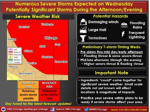
Here is a look at the expected timeline for severe weather for today:

Local Doppler Radar

Get Patched In
Get more local news delivered straight to your inbox. Sign up for free Patch newsletters and alerts.