Weather
Brutal Heat Continues Through Sunday, Severe Storms Possible: Weekend Weather
A look at this weekend's weather forecast for the Chicago area.


An excessive heat warning will remain in effect through Saturday evening as temperatures are expected to soar through this weekend for much of the suburbs.
Maximum heat index values could reach between 105 to 116 degrees on Friday and be between 100 and 105 degrees on Saturday. Sunday is also expected to be hot with temperatures reaching a high in the lower 90s and the highest heat index readings expected to be between 100 to 105 in the afternoon.
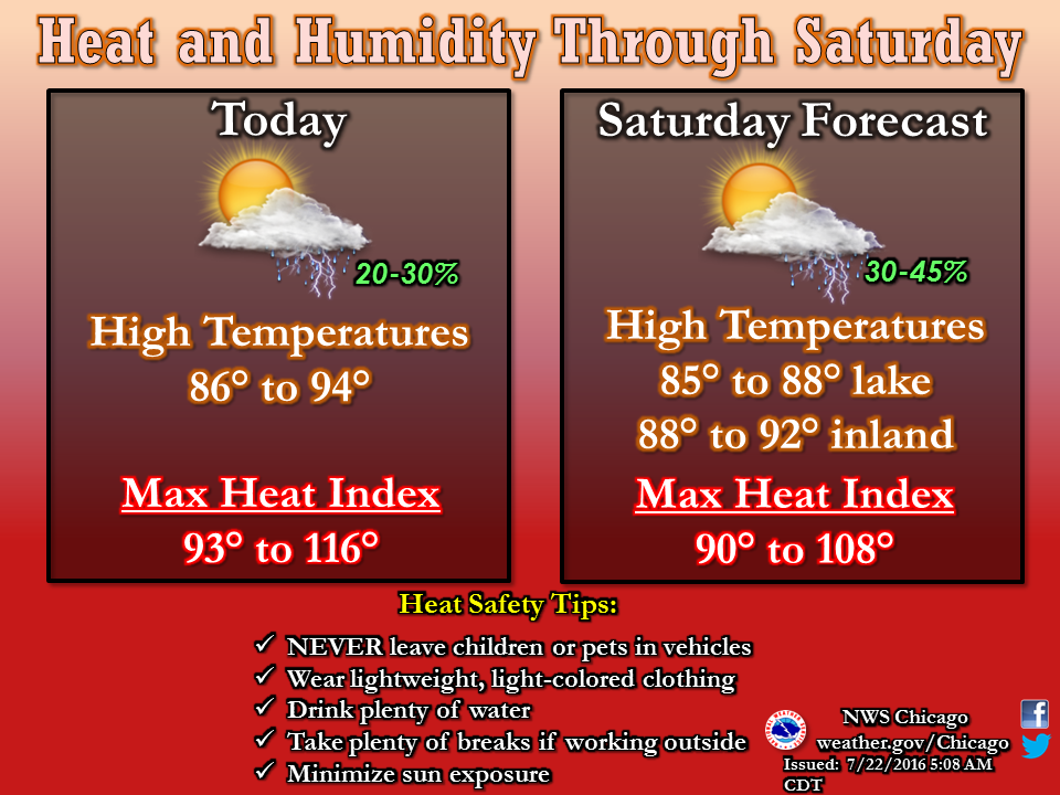
In addition to the heat, isolated thunderstorms could enter the Chicago area Friday afternoon. Here is more from the National Weather Service:
Find out what's happening in Grayslakefor free with the latest updates from Patch.
Confidence is low in thunderstorm development this afternoon and it could be dry. The chance of thunderstorms shifts along and south of I-80 this evening as a front stalls over northern Illinois. Isolated severe storms are possible but widespread severe weather is not expected.
There is also a “limited severe thunderstorm risk” on Saturday and Sunday. Thunderstorms on Saturday could increase in coverage through Saturday night, according to the National Weather Service.
As we head into Sunday, the dangerous heat could continue. Drier and cooler conditions are expected for the beginning of the work week.
Find out what's happening in Grayslakefor free with the latest updates from Patch.
- Friday: Cloudy during the predawn hours then becoming partly sunny. A 30 percent chance of showers and thunderstorms in the afternoon. Highs in the lower 90s. Highest heat index readings 102 to 107. Southwest winds 5 to 10 mph.
- Friday night: Partly cloudy. A 20 percent chance of showers and thunderstorms in the evening. Lows in the mid 70s. East winds 5 to 10 mph.
- Saturday: Partly cloudy with a 30 percent chance of showers and thunderstorms. Highs in the lower 90s inland...but only in the mid 80s near the lake. Highest heat index readings 97 to 102 in the afternoon. Southeast winds 5 to 10 mph.
- Saturday Night: Mostly cloudy. Chance of showers and thunderstorms in the evening...then showers and thunderstorms likely after midnight. Lows in the mid 70s. South winds 5 to 10 mph. Chance of precipitation 60 percent.
- Sunday: Partly sunny with a 40 percent chance of showers and thunderstorms. Highs in the lower 90s. Highest heat index readings 100 to 105 in the afternoon. Southwest winds 10 to 15 mph.
- Sunday Night: Partly cloudy with a 30 percent chance of showers and thunderstorms. Lows in the lower 70s.
- Monday: Partly cloudy in the morning then clearing. Highs in the mid 80s inland...but only in the lower 80s near the lake.
Would you like to see your outdoors or weather photo featured in our weekend or week-ahead weather report? E-mail a photo with a brief description to dennis@patch.com. Please include your hometown.
Get more local news delivered straight to your inbox. Sign up for free Patch newsletters and alerts.