Community Corner
New Storm Warnings Issued, Severe Weather Possible Monday
Several severe thunderstorm warnings have been issued as storms roll into the area Monday.

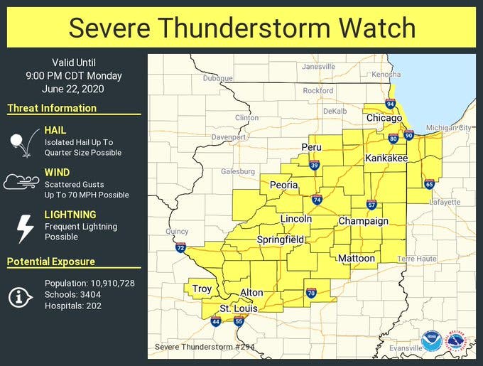
ILLINOIS — A severe thunderstorm watch and several severe thunderstorm warnings have been issued Monday as storms roll into the Chicago area. The National Weather Service said several periods of thunderstorm will impact the area, and damaging winds and locally heavy rain are the main hazards with these storms.
More organized thunderstorms are possible mid to late afternoon into the early evening Monday, with the highest concern from 3 to 10 p.m., according to the weather service.
Currently, there is a severe thunderstorm warning issued until 2:30 p.m. for Joliet, Orland Park, Tinley Park, Romeoville, Lockport, New Lenox, Homer Glen, Mokena, Frankfort, Channahon, Minooka, University Park, Ingalls Park, Shorewood, Manhattan, Elwood, Rockdale, Goodings Grove, Crest Hill and Frankfort Square. The storm was located over Channahon at 1:28 p.m., moving northeast at 20 mph, the weather service said.
Find out what's happening in Homer Glen-Lockportfor free with the latest updates from Patch.
There is a second warning until 2:15 p.m. for Orland Park, Tinley Park, Calumet City, Chicago Heights, Lansing, New Lenox, Blue Island, Dolton, Park Forest, Matteson, Mokena, Frankfort, Midlothian, Steger, Flossmoor, Lynwood, Glenwood, University Park, Posen and Olympia Fields. The weather service said this storm was located near Frankfort at 1:12 p.m. and is moving northeast at 20 mph.
60 mph wind gusts and hail are possible with both storms, according to the weather service.
Find out what's happening in Homer Glen-Lockportfor free with the latest updates from Patch.
A severe thunderstorm watch has been issued until 9 p.m. for a large part of Illinois, including Cook, Kendall, La Salle, Grundy, Kankakee and Will counties.
Get more local news delivered straight to your inbox. Sign up for free Patch newsletters and alerts.