Politics & Government
Everywhere You Go In Joliet, You Will Start To See This Vehicle: City Of Joliet Explains Why
It is expected that the mapping project will take 4-6 weeks to complete.

(The following press release is from Sydney Thompson at Joliet's City Hall.)
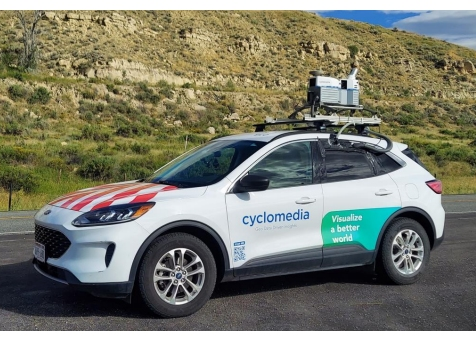
JOLIET,IL — The City of Joliet, in partnership with Cyclomedia Technology, will begin a roadway mapping and roadway surface assessment project beginning the week of June 15,
2026. Roadway mapping includes street level photography of all streets within City limits and provides 360-degree imagery with measurable three-dimensional coordinates utilizing LIDAR technology.
It is expected that the mapping project will take 4-6 weeks to complete. Residents can expect to see a vehicle similar to the one pictured below driving City streets during this timeframe.
For additional information, contact the City of Joliet Department of Public Works at 815-724-4200.
Find out what's happening in Jolietfor free with the latest updates from Patch.
Get more local news delivered straight to your inbox. Sign up for free Patch newsletters and alerts.