Weather
7 Inches Of Snow Before -40 Wind Chill Moves In To IL
More snow and a historic cold snap is on the way for the Chicago area.


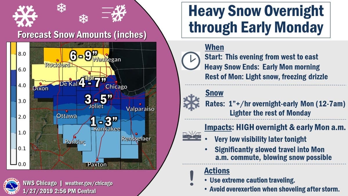
A week full of wintry weather is ahead of us, starting with some heavy snow on Sunday night into Monday. The National Weather Service has issued a winter weather advisory which is in effect from 9 p.m. Sunday until 6 p.m. Monday for Kane, DuPage, Cook, Kendall, Grundy and Will counties.
The NWS said heavy snow and blowing snow will begin Sunday night and continue into Monday. Total snow accumulations of 3 to 7 inches are possible.
The snow could impact the Monday morning commute, and could make travel very difficult. Generally, the farther north you live, the more snow you'll receive, with most of the Chicago suburbs falling in the 4 to 7 inch or 3 to 5 inch range.
Find out what's happening in Lemontfor free with the latest updates from Patch.
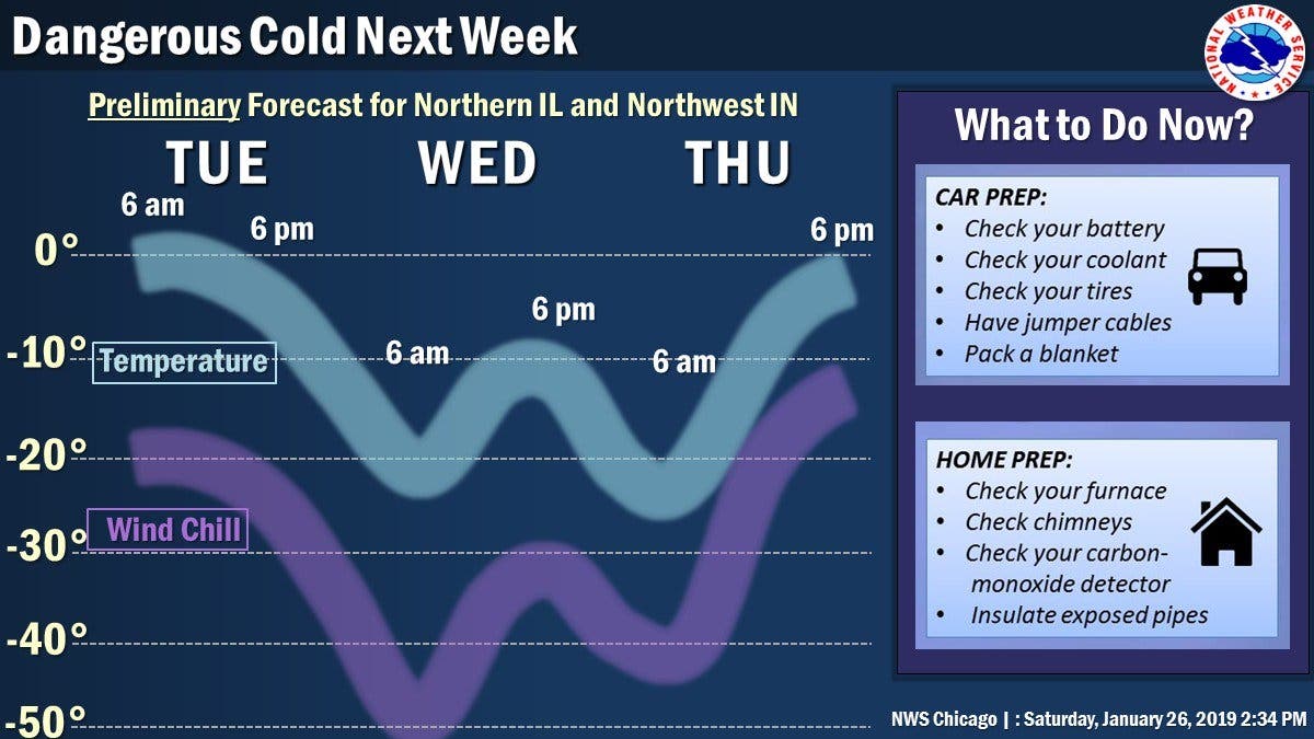
After the snow on Monday, possibly historic cold will move into the area. The high for Tuesday during the day is 3 degrees, according to the NWS. Temps will then drop to -20 on Tuesday night with wind chills of at least -40. Wednesday will be even colder, with highs of -10 degrees during the day with wind chill values of -30. Thursday will be the last day of the cold snap, with a high near 2 degrees.
Here is a look at your weather this week:
Find out what's happening in Lemontfor free with the latest updates from Patch.
- MONDAY: Drizzle and snow, possibly mixed with freezing drizzle before 2 p.m., then a chance of snow and freezing drizzle between 2 p.m. and 3 p.m., then a chance of snow after 3 p.m. The snow could be heavy at times. Patchy blowing snow before 8 a.m. Temperature rising to near 33 by 10 a.m., then falling to around 18 during the remainder of the day. Breezy, with a south wind 15 to 20 mph becoming west northwest in the afternoon. Winds could gust as high as 35 mph. Chance of precipitation is 100%. Little or no ice accumulation expected. New snow accumulation of 1 to 2 inches possible.
- MONDAY NIGHT: A 50 percent chance of snow, mainly before 7 p.m. Mostly cloudy, with a low around 1. Wind chill values as low as -15. Blustery, with a northwest wind 15 to 20 mph, with gusts as high as 30 mph.
- TUESDAY: Partly sunny and cold, with a high near 3. Breezy, with a west wind 15 to 20 mph, with gusts as high as 30 mph.
- TUESDAY NIGHT: Mostly cloudy, with a low around -23.
- WEDNESDAY: Partly sunny and cold, with a high near -14.
- WEDNESDAY NIGHT: Partly cloudy, with a low around -23.
- THURSDAY: A chance of snow after 1 p.m. Partly sunny and cold, with a high near 2.
- THURSDAY NIGHT: A chance of snow, mainly after 1am. Mostly cloudy, with a low around -1.
- FRIDAY: A chance of snow. Partly sunny, with a high near 22.
- FRIDAY NIGHT: Partly cloudy, with a low around 14.
Image by Patch.
Get more local news delivered straight to your inbox. Sign up for free Patch newsletters and alerts.