Weather
Snow, Flurries Possible Before Temps Warm To The 40s: IL Weather
We could still see a few snowflakes this weekend, but accumulation isn't likely.


ILLINOIS — After several days of snowfall, we aren't in the clear yet in Illinois. The National Weather Service said a mix of light rain and snow is expected Friday afternoon into Friday evening. The mix of rain and snow could then transition to snow for a few hours, but accumulations will be under an inch.
Saturday could also see some flurries, but there won't be accumulations like there have been the past few days.
Find out what's happening in Lemontfor free with the latest updates from Patch.
See Halloween 2019 Snowfall Totals here
Temps will be in the 30s Saturday, the weather service said. Sunday will be slightly warmer with a high of 47 degrees, and it should be mostly cloudy.
Find out what's happening in Lemontfor free with the latest updates from Patch.
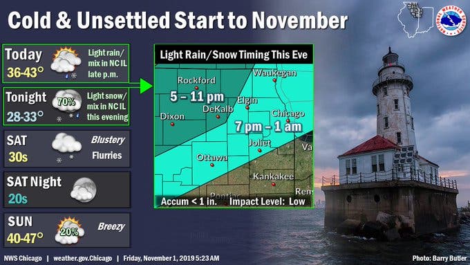
- FRIDAY NIGHT: Rain and snow likely, mainly between 9 p.m. and midnight. Cloudy, with a low around 32. South southwest wind around 10 mph. Chance of precipitation is 60 percent. New snow accumulation of less than a half inch possible.
- SATURDAY: A chance of flurries after 11 a.m. Mostly cloudy, with a steady temperature around 34. West wind 5 to 15 mph, with gusts as high as 25 mph.
- SATURDAY NIGHT: A chance of flurries before 8 p.m. Mostly cloudy, with a low around 27. West wind 5 to 15 mph, with gusts as high as 25 mph.
- SUNDAY: Mostly cloudy, with a high near 44. South wind 5 to 15 mph, with gusts as high as 25 mph.
- SUNDAY NIGHT: Mostly cloudy, with a low around 34.
Get more local news delivered straight to your inbox. Sign up for free Patch newsletters and alerts.