Weather
Illinois Flood Watch: Several Inches Of Rain In Forecast
The beginning of the week could see several inches of rain for most of the area.

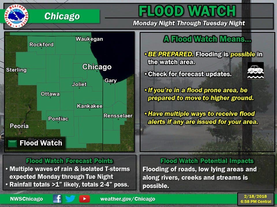
The start of the work week will be a rainy one, and the National Weather Service has issued a flood watch from Monday night through Tuesday night for most of the area. The watch has been issued for Cook, DeKalb, DuPage, Ford, Grundy, Iroquois, Kane, Kankakee, Kendall and Will counties.
According to the watch, unseasonably warm and moist air will spread over the region the next few days. Several rounds of rain and thunderstorms are expected between early Monday and Wednesday. Most areas will see over an inch of rain, while localized amounts of 2 to 4 inches is possible.
The rain will be around on Monday and Tuesday, and so will some mild temperatures. The high for Monday is 59 degrees, while Tuesday has a high of 62. The rain will stick around early Wednesday, according to the NWS, but should end after noon.
Find out what's happening in Lemontfor free with the latest updates from Patch.
Thursday will be partly sunny and with more seasonable temperatures. There is another chance of rain or even snow on Friday, and the high is around 45 degrees.
Here is a more detailed look at the weather for the week ahead:
Find out what's happening in Lemontfor free with the latest updates from Patch.
- MONDAY: Showers likely, then showers and possibly a thunderstorm after 9 a.m. Patchy fog. High near 59. South southwest wind 10 to 15 mph, with gusts as high as 25 mph. Chance of precipitation is 90 percent. New rainfall amounts between a quarter and half of an inch possible.
- MONDAY NIGHT: Showers and possibly a thunderstorm. Some of the storms could produce heavy rain. Low around 53. South southwest wind 10 to 15 mph, with gusts as high as 25 mph. Chance of precipitation is 100 percent. New rainfall amounts between three quarters and one inch possible.
- TUESDAY: Showers and possibly a thunderstorm. Some of the storms could produce heavy rain. High near 62. South southwest wind 10 to 15 mph, with gusts as high as 25 mph. Chance of precipitation is 90 percent.
- TUESDAY NIGHT: Rain before 4 a.m., then rain likely, possibly mixed with freezing rain between 4 a.m. and 5 a.m., then freezing rain likely, possibly mixed with sleet after 5 a.m. Low around 30. Southwest wind 10 to 15 mph becoming north northwest after midnight. Winds could gust as high as 20 mph. Chance of precipitation is 90 percent.
- WEDNESDAY: A slight chance of freezing rain and sleet before 10 a.m., then a slight chance of snow and sleet between 10 a.m. and noon. Mostly cloudy, with a high near 36. Chance of precipitation is 20 percent.
- WEDNESDAY NIGHT: A 20 percent chance of snow after midnight. Mostly cloudy, with a low around 25.
- THURSDAY: Partly sunny, with a high near 39.
- THURSDAY NIGHT: A slight chance of snow after midnight. Mostly cloudy, with a low around 31.
- FRIDAY: A chance of snow before 7 a.m., then a chance of rain and snow between 7 a.m. and 9 a.m., then a chance of rain after 9 a.m. Mostly cloudy, with a high near 45.
- FRIDAY NIGHT: Rain and snow likely. Cloudy, with a low around 36.
Get more local news delivered straight to your inbox. Sign up for free Patch newsletters and alerts.