Weather
Severe Storms Could Hit Illinois On Tuesday
A spring storm on Tuesday will bring rain, storms and snow to northern Illinois.


Spring has not sprung yet. Some areas in northern Illinois will see some snow Tuesday night, as well as some rain and thunderstorms. According to the National Weather Service, a spring storm will roll into the area on Tuesday.
A strong low pressure system will move into the area Tuesday, and cause thunderstorms with possibly heavy downpours. According to the NWS, there is a risk for isolated strong to severe thunderstorms, mainly southeast of I-55.
The rain will change over to snow before ending Tuesday night. There could be minor accumulations of up to two inches possible, mainly in far northern Illinois. Winds will also be a factor on Tuesday night, and could gust up to 35 mph in some spots.
Find out what's happening in Lemontfor free with the latest updates from Patch.
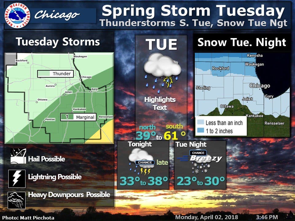
After Tuesday's spring storm, the rest of the week is calm, although unseasonably chilly. Wednesday will be partly sunny with a high near 37, while Thursday's high will be near 42 degrees. There is a slight chance of snow and rain again on Thursday as well, according to the NWS.
The chilly temperatures will stick around on Friday too, with the high forecast at 38 degrees.
Find out what's happening in Lemontfor free with the latest updates from Patch.
Here is a more detailed look at your forecast for the week:
- MONDAY NIGHT: Rain or drizzle likely, mainly after 4 a.m. Cloudy, with a low around 39. Southeast wind 5 to 10 mph. Chance of precipitation is 60 percent. New precipitation amounts of less than a tenth of an inch possible.
- TUESDAY: Rain and possibly a thunderstorm before 7 a.m., then showers and possibly a thunderstorm between 7 a.m. and 4 p.m., then showers after 4 p.m. High near 47. East wind 5 to 10 mph becoming north 10 to 15 mph in the afternoon. Winds could gust as high as 20 mph. Chance of precipitation is 90 percent. New rainfall amounts between a quarter and half of an inch possible.
- TUESDAY NIGHT: A chance of rain before 10 p.m., then a chance of rain and snow between 10 p.m. and midnight, then a chance of snow after midnight. Cloudy, with a low around 27. Blustery, with a northwest wind 15 to 20 mph, with gusts as high as 30 mph. Chance of precipitation is 50 percent.
- WEDNESDAY: Partly sunny, with a high near 37. Northwest wind around 15 mph, with gusts as high as 30 mph.
- WEDNESDAY NIGHT: Partly cloudy, with a low around 23.
- THURSDAY: A slight chance of snow before noon, then a slight chance of rain and snow between noon and 1 p.m., then a chance of rain after 1 p.m. Mostly cloudy, with a high near 42. Chance of precipitation is 30 percent.
- THURSDAY NIGHT: Mostly cloudy, with a low around 24.
- FRIDAY: Partly sunny, with a high near 38.
- FRIDAY NIGHT: Partly cloudy, with a low around 21.
Get more local news delivered straight to your inbox. Sign up for free Patch newsletters and alerts.