Community Corner
Storms Expected For The Weekend, Temps In The 80s For IL
Storms are possible Saturday afternoon and evening, with the highest chance on Saturday evening.


ILLINOIS — Storms are possible this weekend as temperatures remain in the 80s on Saturday and Sunday. According to the National Weather Service, it will be 85 on Saturday and 79 on Sunday.
Storms are possible Saturday afternoon and evening, with the highest chance on Saturday evening. There is also a chance of storms on Sunday morning.
There is a limited severe thunderstorm risk on Saturday and Sunday, according to the weather service. Dangerous swim conditions are also expected along the northwest Indiana shorelines.
Find out what's happening in Lemontfor free with the latest updates from Patch.
After a slightly cooler weekend, the weather service said there could be a potential heat wave moving in the area next week. There is still uncertainty on how hot it will get and where heat will be.
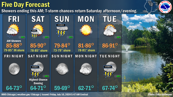
Here is a more detailed look at the weather this weekend:
Find out what's happening in Lemontfor free with the latest updates from Patch.
FRIDAY NIGHT: Mostly clear, with a low around 65. West northwest wind 5 to 15 mph, with gusts as high as 25 mph.
SATURDAY: A 30 percent chance of showers and thunderstorms, mainly after 4 p.m. Increasing clouds, with a high near 85. West northwest wind 5 to 10 mph.
SATURDAY NIGHT: Showers and thunderstorms likely, mainly between 7 p.m. and 1 a.m. Mostly cloudy, with a low around 67. West northwest wind around 5 mph. Chance of precipitation is 60 percent. New rainfall amounts between a quarter and half of an inch possible.
SUNDAY: 40 percent chance of showers and thunderstorms before 1 p.m. Mostly sunny, with a high near 80. North northeast wind 5 to 15 mph.
SUNDAY NIGHT: Mostly clear, with a low around 63. North northeast wind 5 to 10 mph becoming light and variable after midnight.
Get more local news delivered straight to your inbox. Sign up for free Patch newsletters and alerts.