Weather
Scorching Heat, Humidity To Bring Severe Storms To MD: See Forecast
Hot and humid conditions hitting MD this week are expected to send feel-like temperatures into the triple digits, forecasters say.

Hot and humid conditions will envelop Maryland this week, and forecasters are warning that residents are likely to see feels-like temperatures soar past the 100-degree mark.
Wednesday carries a chance for isolated showers and thunderstorms in the morning and afternoon as humidity begins to spike across the region.
Temperatures through Wednesday are anticipated to reach the upper 80s, before the heat kicks up a few notches toward the end of the week.
Find out what's happening in Across Marylandfor free with the latest updates from Patch.

Forecasters say Marylanders will see temperatures in the 90s on Thursday and Friday, but that feels-like readings could reach a scorching 105 degrees for several hours each day.
AccuWeather Senior Meteorologist Brett Anderson said that "some daily record highs may be set for multiple days in multiple locations."
Find out what's happening in Across Marylandfor free with the latest updates from Patch.
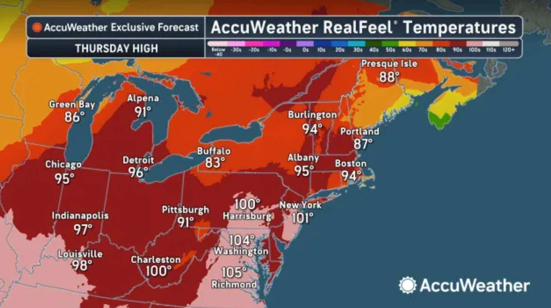
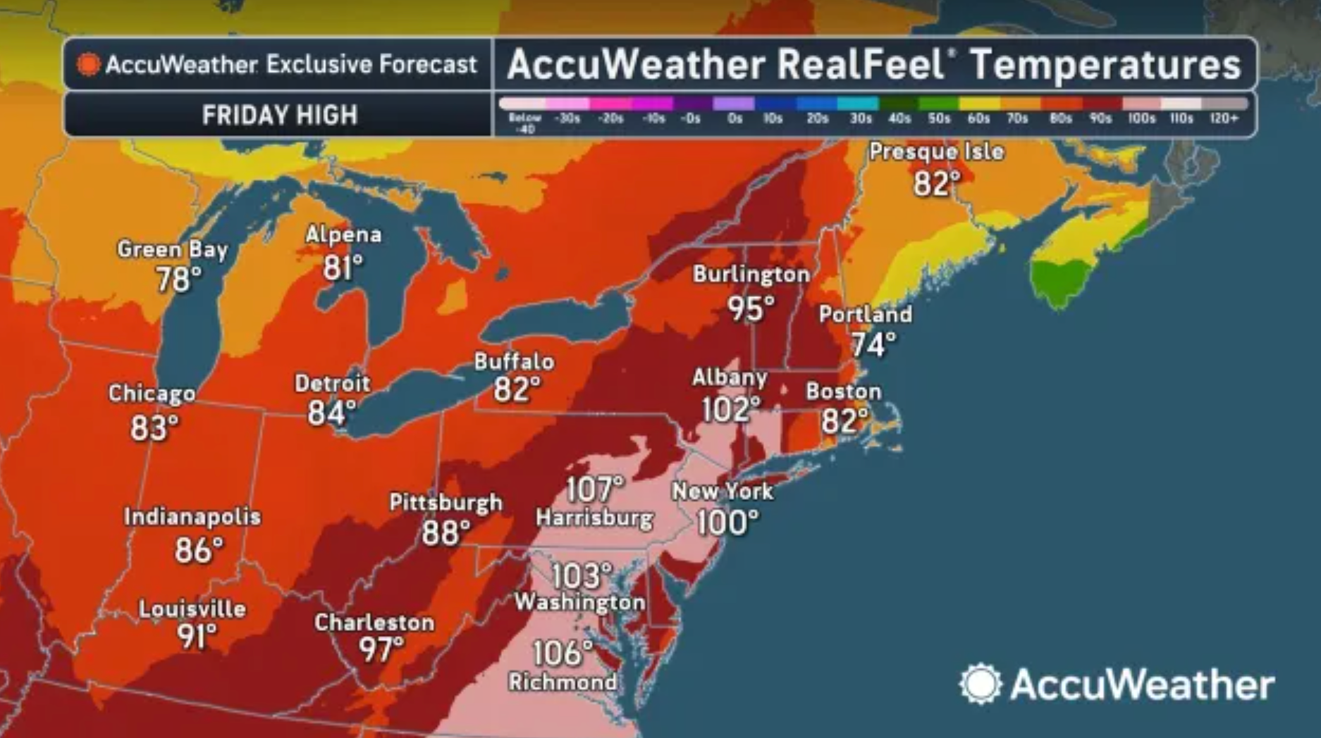
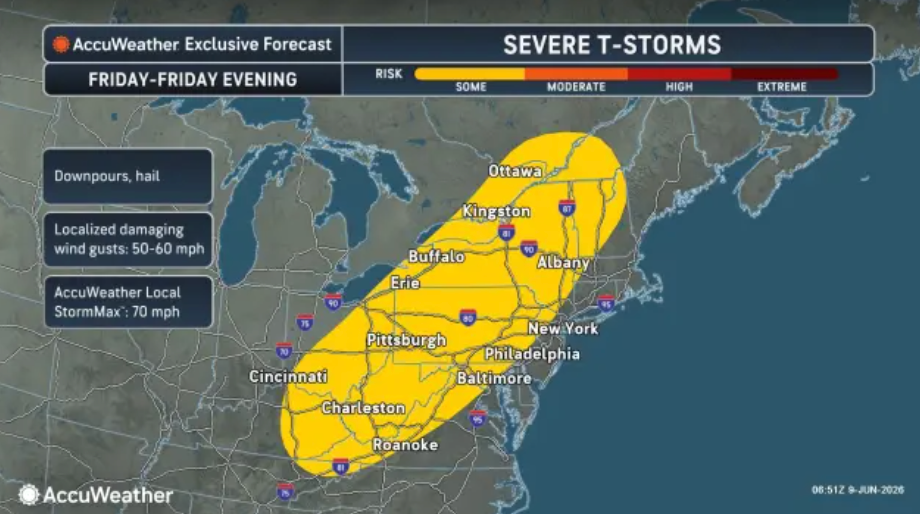
However, the routine humid heat moving into the Old Line State will also bring a chance for severe thunderstorms. Officials say the storms have the potential to produce damaging wind gusts of up to 60 mph on Thursday and Friday.

No official warnings have been issued ahead of the storms, but residents are urged to be cautious while working outdoors during the latest heat spell.
The National Weather Service says the looming heat blast could impact individuals who are extremely sensitive to heat.
By the time the weekend rolls around, residents will have more of a chance to enjoy the outdoors as temperatures peak in the upper 80s.
Related: Parts of Maryland Now Under Drought Watch
The latest comes as parts of Maryland remain under a regional drought watch due to record-high temperatures and low rainfall and streamflow levels. It marks the second such watch in less than two years.
Here's the detailed forecast for the Baltimore region:
Tuesday Night: Mostly cloudy, with a low around 67. South wind 5 to 11 mph, with gusts as high as 21 mph.
Wednesday: A chance of showers and thunderstorms before 4pm, then showers likely and possibly a thunderstorm between 4pm and 5pm, then a chance of showers and thunderstorms after 5pm. Mostly cloudy, with a high near 89. Southwest wind 5 to 8 mph. Chance of precipitation is 60%. New rainfall amounts of less than a tenth of an inch, except higher amounts possible in thunderstorms.
Wednesday Night: A chance of showers and thunderstorms, mainly before 8pm. Partly cloudy, with a low around 71. South wind 3 to 5 mph. Chance of precipitation is 30%.
Thursday: A chance of showers and thunderstorms after 2pm. Mostly sunny, with a high near 96. Heat index values as high as 104. West wind 5 to 7 mph. Chance of precipitation is 40%.
Thursday Night: A chance of showers and thunderstorms before 11pm, then a chance of showers between 11pm and 2am. Mostly cloudy, with a low around 74. Light west wind. Chance of precipitation is 40%.
Friday: A chance of showers and thunderstorms after 2pm. Partly sunny and hot, with a high near 97. Chance of precipitation is 40%.
Friday Night: A chance of showers and thunderstorms before 2am. Mostly cloudy, with a low around 70. Chance of precipitation is 50%.
Saturday: Sunny, with a high near 90.
Saturday Night: Mostly clear, with a low around 68.
Sunday: Mostly sunny, with a high near 92.
Get more local news delivered straight to your inbox. Sign up for free Patch newsletters and alerts.