Weather
Sweltering 100-Degree Temperatures Return To MD This Week: See Latest Forecast
Sweat-inducing heat will make a grand return to Maryland this week. Forecasters anticipate temperatures reaching near record conditions.


Scorching triple-digit temperatures will descend across Maryland this week, as heat index values are forecast to get into the 100-degree territory.
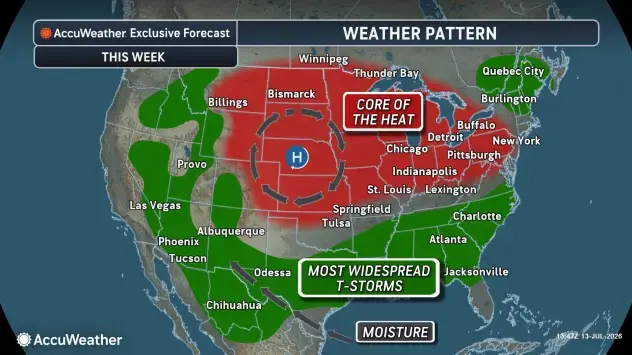
While the core of the latest heat dome won't be directly over the state, Marylanders still won't be getting much of a reprieve from the blistering conditions.
When Does The Heat Hit?
The National Weather Service said temperatures will only continue to increase through the week after Monday's readings peaked in the high 80s.
Find out what's happening in Across Marylandfor free with the latest updates from Patch.
By Tuesday, temperatures will creep into the high 90s.
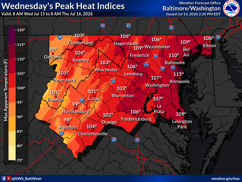
Residents can expect the peak of the heat to arrive Wednesday and stick around through Thursday. Officials say near-record temperatures could get as high as 106 degrees.
Find out what's happening in Across Marylandfor free with the latest updates from Patch.
One graphic released by NWS on Monday shows Annapolis forecast to record a peak heat of 115 degrees.
Meteorologists are warning that heat conditions could prompt the NWS' heat risk ranking to reach extreme, a level that dictates conditions are seriously dangerous for anyone without access to cooling or hydration options.
An extreme heat watch has already been issued by the NWS for the Kent, Queen Anne's and Talbot counties for Wednesday.
Safety Tips
Residents are urged to limit their time outdoors, keep hydrated, and be aware of nearby cooling centers in cases of emergency.
"Be sure to check in on family, friends and neighbors," reads an NWS notice. "Additionally, never leave children or animals unattended in vehicles!"
The Maryland Department of Health provided a list for local cooling centers online.
Detailed Forecast For Baltimore Region
Monday Night: Clear, with a low around 67. Southeast wind around 6 mph becoming calm in the evening.
Tuesday: Sunny, with a high near 91. Calm wind becoming southwest 5 to 7 mph in the afternoon.
Tuesday Night: Clear, with a low around 73. Southwest wind around 7 mph.
Wednesday: Sunny and hot, with a high near 99. Heat index values as high as 106. West wind 6 to 9 mph.
Wednesday Night: Mostly clear, with a low around 77. West wind 3 to 7 mph.
Thursday: Sunny and hot, with a high near 98.
Thursday Night: Partly cloudy, with a low around 76.
Friday: Sunny and hot, with a high near 97.
Friday Night: A slight chance of showers and thunderstorms before 2 a.m. Partly cloudy, with a low around 75. Chance of precipitation is 20%.
Saturday: A chance of showers and thunderstorms after 2 p.m. Mostly sunny, with a high near 96. Chance of precipitation is 50%.
Saturday Night: A chance of showers and thunderstorms. Mostly cloudy, with a low around 74. Chance of precipitation is 50%.
Sunday: A chance of showers and thunderstorms. Partly sunny, with a high near 89. Chance of precipitation is 50%.
Sunday Night: A chance of showers and thunderstorms. Mostly cloudy, with a low around 71. Chance of precipitation is 30%.
Monday: A chance of showers and thunderstorms. Mostly sunny, with a high near 86. Chance of precipitation is 40%.
Get more local news delivered straight to your inbox. Sign up for free Patch newsletters and alerts.