Weather
Flash Flood Watch Issued For 10 MD Counties: Weekend Weather
Maryland's Easter weekend weather forecast begins with a flash flood watch as 3 inches of rain is possible on Friday.

BALTIMORE, MD — Maryland's Easter weekend weather forecast begins with a flash flood watch issued by the National Weather Service for ten counties starting Friday afternoon into Saturday with thunderstorms expected that could dump 3 inches of rain in parts of the state. The forecast calls for rain off and on until late in the day on Sunday, although Easter egg hunts set for Saturday afternoon may have dry skies.
The Washington Post's Capital Weather Gang describes the weekend this way: "Another vigorous, springtime cyclone is poised to cross our region Friday afternoon through Saturday morning. In the immediate D.C. region, flooding rains are the biggest concern, but scattered damaging wind gusts from strong to severe thunderstorms remain on the table."
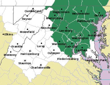
These parts of Maryland are under the flash flood watch from noon Friday, April 18, to 5 a.m. on Saturday, April 19: Anne Arundel, Carroll, Howard, Montgomery, Charles, Frederick, Baltimore, Harford, Prince George's and Washington counties.
Find out what's happening in Annapolisfor free with the latest updates from Patch.
Cities in the watch area include: Baltimore, Bowie, Suitland-Silver Hill, Clinton, College Park, Greenbelt, Laurel, Camp Springs, Glen Burnie, Annapolis, Severn, South Gate, Severna Park, Arnold, Odenton, St. Charles, Waldorf, Germantown, Damascus, Bethesda, Rockville, Gaithersburg, Silver Spring, Lisbon, Columbia, Ellicott City, Jarrettsville, and Aberdeen.
Washington, D.C., and much of northern Virginia is also under the watch.
Find out what's happening in Annapolisfor free with the latest updates from Patch.
"Thunderstorms with heavy rain may cause flooding. Severe weather is also a threat," the National Weather Service posted.
Friday afternoon, evening and nighttime thunderstorms could bring very heavy rain and high winds to the region, the Capital Weather Gang writes. A cold front removes the risk of heavy rain risk Saturday and Sunday, but scattered showers are possible into Sunday morning.
Here's the detailed forecast from the National Weather Service:
Thursday afternoon: Partly sunny, with a high near 79. South wind 5 to 7 mph.
Thursday Night: Increasing clouds, with a low around 63. South wind around 10 mph, with gusts as high as 21 mph.
Friday: Showers likely and possibly a thunderstorm, then showers and thunderstorms after noon. Some of the storms could produce gusty winds and heavy rain. High near 75. South wind 11 to 16 mph, with gusts as high as 31 mph. Chance of precipitation is 90%. New rainfall amounts between a quarter and half of an inch possible.
Friday Night: Showers and thunderstorms before midnight, then showers and possibly a thunderstorm, mainly after midnight. Some of the storms could produce gusty winds and heavy rain. Low around 62. South wind 13 to 16 mph, with gusts as high as 31 mph. Chance of precipitation is 90%. New rainfall amounts between three quarters and one inch possible.
Saturday: Showers likely, mainly before 8am. Mostly cloudy, with a high near 71. South wind 10 to 14 mph, with gusts as high as 28 mph. Chance of precipitation is 60%.
Saturday Night: A slight chance of showers before 8pm, then a slight chance of showers after 11pm. Mostly cloudy, with a low around 51. Chance of precipitation is 20%.
Sunday: A chance of showers. Partly sunny, with a high near 65. Chance of precipitation is 40%.
Sunday Night: Partly cloudy, with a low around 52.
Monday: Mostly sunny, with a high near 75
Get more local news delivered straight to your inbox. Sign up for free Patch newsletters and alerts.