Weather
MD Nor'Easter: 200K Lose Power, Bridges Close, State Of Emergency
Winds could reach 80 mph, say weather forecasters. School and bridge closings, 200K without power and tips to stay safe in storm.

ANNAPOLIS, MD — Power outages climbed to more than 200,000 utility customers across Maryland, airports reported flight delays, Amtrak halted Northeast Corridor service and school districts canceled classes Friday as wind gusts reached 70 mph with the arrival of a nor'easter in the Baltimore-Washington region. As the storm strengthened it reached the category now known as a bomb cyclone, with gusts up to 60 mph at 10 p.m. Maryland Gov. Larry Hogan declared a state of emergency Friday evening. Authorities warned of dangerous driving conditions, projectiles that could injure pedestrians, power outages from fallen tree limbs, and broken windows from flying debris.
BGE said that its crews had restored power to 175,000 customers across the state by 10 p.m. Check for updates on the BGE outage map. PEPCO showed 215,844 customers in Maryland and Northern Virginia had no electricity, and the Maryland Emergency Management power outage map was also down. The Baltimore Sun reported a total of 200,000 power outages had been reported by Friday afternoon.
About 10:20 p.m. Friday the utility said 36,800 customers remained without power in Anne Arundel County, 56,800 were in the dark in Baltimore County, and 36,900 customers in the city of Baltimore were without power.
Find out what's happening in Annapolisfor free with the latest updates from Patch.
At least two tractor-trailer trucks were flipped over on the state's bridges Friday by the fierce winds. The Chesapeake Bay Bridge was closed for an hour, reopened and closed again, a condition likely to repeat until winds calm. The Hatem Bridge was temporarily closed Friday afternoon because of a downed tree. Officials reported all lanes on US 40 at the Hatem Bridge were closed.
The Tydings Bridge remains closed after two tractor trailers crashed on separate sides of the bridge before noon. See the latest lane closure information from state transportation officials. (For more news like this, find your local Patch here. If you have an iPhone, click here to get the free Patch iPhone app; download the free Patch Android app here.)
Find out what's happening in Annapolisfor free with the latest updates from Patch.
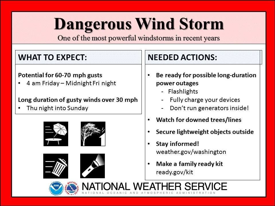
Wind speeds could top those that Superstorm Sandy brought to the state in October 2012, forecasters say, which were in the 61 mph range. "Isolated wind gusts could reach 80 mph, particularly at higher elevations west of the Interstate 95 corridor," the weather service says.
Hogan declared a state of emergency beginning Friday, March 2, in the wake of damaging winds resulting in power outages, downed trees, and dangerous travel conditions across the state. The executive order will allow the state to coordinate support and help local jurisdictions. Dangerous conditions may continue throughout Saturday, March 3.
SEE ALSO: Top MD Wind Gusts Town By Town For March 2 2018
“I want to caution all Marylanders that these dangerously strong winds will continue this evening and into tomorrow. We are continuing to see a number of serious accidents on bridges and roadways, and power outages throughout the state,” Hogan said. “Please use common sense, heed all warnings, and stay inside and off the roads if possible.”
Amtrak service has been suspended between Washington, D.C. and Boston because of the fierce winds, although trains en route will continue to the nearest station. Amtrak Keystone Service is also temporarily suspended until further notice. All trains currently operating along the Northeast Corridor will continue to the nearest station. Passengers with travel plans also can confirm their train's status, change their plans or review refund information on Amtrak.com.
At 7 a.m. the National Weather Service reported wind gusts at Washington Dulles International Airport of 67 mph, Washington Reagan National Airport of 62 mph, Naval Air Station Patuxent River of 66 mph, Joint Force Andrews of 62 mph, and Baltimore/Washington International Marshall Airport of 52 mph. Other high wind gust reports include of 69 mph in Gaithersburg and 71 mph at Ballenger Creek in Frederick County.
Schools in Prince George's, Montgomery, Carroll, Baltimore, Frederick, Howard, and Garrett counties and Baltimore City are closed on Friday. Schools in Cecil County dismissed early.
Wind speeds of 40 and 60 mph were common across the state at 6 p.m. While gusts will slowly diminish in intensity this weekend, they will remain around 40 mph on Saturday, the National Weather Service said. This will hamper the repair of power lines and tree removal. Travel is dangerous on the roads, especially for high profile vehicles, and downed trees and power lines are road hazards.
The storm underwent rapid strengthening as part of a process called "bombogenesis." The storm apparently evolved into something shaped like – and as powerful as – a hurricane, creating what is known as a "bomb cyclone," according to the National Weather Service.
Many downed trees and power lines are expected during the lengthy storm, which isn't expected to decrease in strength until Sunday afternoon, when wind speeds should drop below 30 mph. The prolonged period of strong winds will knock down power lines and hamper the repair work by utility and tree crews.
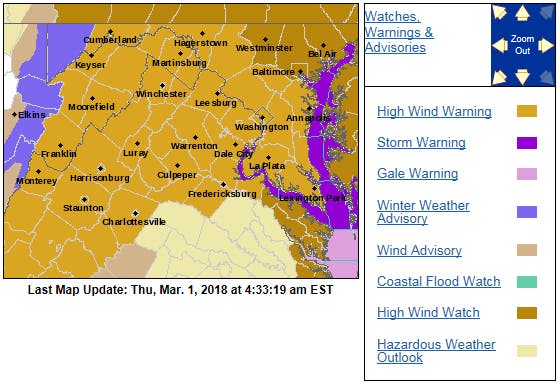
A high wind warning is in effect until 6 a.m. Saturday across the region.
Important Maryland Utility Numbers Include:
- PEPCO: 1-877-737-2662
- Baltimore Gas and Electric (BG&E): 1-877-778-2222 or 1-800-685-0123
- First Energy/Potomac Edison: 1-888-544-4877
- SMECO: 1-877-747-6326 or 1-888-440-3311
- Washington Gas: 1-800-752-7520
- Washington Suburban Sanitary Commission: 1-800-828-4002
Tips For Drivers
The Maryland Department of Transportation’s State Highway Administration reminds drivers to check www.md511.org for travel alerts and conditions, follow the agency on Twitter, or “like” its Facebook page.
If your route includes toll bridges, check out wind warnings and restrictions criteria on the authority’s website. To check if wind restrictions are in place at the Chesapeake Bay Bridge check online or call 1-877 BAYSPAN.
Precautions At Home
In preparation for this upcoming weather, we ask that you continue to monitor your local weather forecasts, follow us on social media, and take proactive measures to prepare before the onset of the wind:
In preparation for potential power outages, individuals should prepare or update their emergency kits. Ensure you have flashlights, batteries, and other items to endure periods without power.
Secure any loose objects, such as outdoor furniture, plants, or lawn ornaments that could become a projectile.
How To Prepare Home, Family For Storm
- Get your emergency kit in order. Plan for at least three days of supplies. Recommended items to include are bottled water, non-perishable food, battery-operated radio, flashlight, extra batteries, toiletries, first aid kit, pet food, prescription medications and copies of important documents (i.e., insurance policies, bank accounts, identification).
- Have a communication plan. Your family may not be together when a storm strikes, so plan on how you will contact one another. Locally, stay in touch with friends, relatives and neighbors. Designate someone out of town, not in the impacted area, to be a backup point of contact.
- See if you are in a flood-prone area. Take any necessary steps if so to get flood-ready.
- Turn the refrigerator and freezer to the coldest setting in anticipation of a power outage. Open the door only when necessary and close quickly. Frozen food in a half-full freezer should remain safe for up to 24 hours, and in a full freezer, up to 48 hours.
- During a power outage use flashlights and battery-powered lanterns for light. Avoid using candles which pose a fire risk.
- Ensure a supply of water for sanitary purposes such as personal cleaning and flushing toilets. Fill a bathtub or other large container with the water. This is particularly important for those whose water runs off of an electrical system.
- If your residence could flood, store valuable and personal papers in a waterproof container.
- Stay indoors and limit travel only to absolutely necessary trips. Allow emergency crews to clear roads and provide emergency assistance.
- Use care around downed power lines. Assume a downed wire is a live wire.
- Watch out for overhead hazards such as broken tree limbs, wires and other debris.
- Make sure backup generators are well ventilated. Never use grills, generators or camping stoves indoors.
This is what the Chesapeake Bay looked like this morning from the cabin of a @MDNRPolice patrol boat answering a distress call. pic.twitter.com/kdL0kF6FW1
— Maryland NRP (@MDNRPolice) March 2, 2018
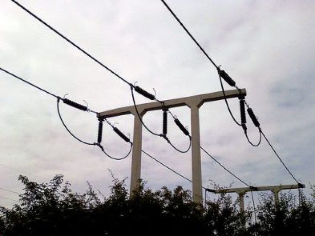
Image via Shutterstock
Get more local news delivered straight to your inbox. Sign up for free Patch newsletters and alerts.