Weather
Maryland Weather Forecast: Snow Chances Increase This Weekend
There are now two chances of snow later this week in Maryland, which would be the first snowfall of the 2017-18 season.


BALTIMORE, MD — A cold front that will chill Maryland through the weekend will bring below-normal temperatures and two chances for snow, according to weather forecasters. As of right now, there is a chance of some snow Friday afternoon and evening, and again Saturday night as low temperatures drop into the 20s, forecasters predict.
It is still too early to know if the snow will in fact materialize, and if it does, if it will be anything more than flurries. Keep your eyes on the forecast if you have weekend travel plans, because areas to the southwest could see slippery road conditions, forecasters say.
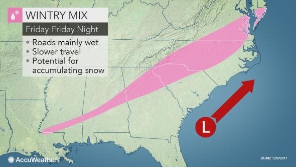
AccuWeather meteorologists say they are monitoring a storm that could bring wintry precipitation from northern Georgia through the Carolinas and into Virginia. There's no indication if that will also affect Maryland, but stay tuned. For the Mid-Atlantic states that means "a bit of morning snow" on Friday.
Find out what's happening in Annapolisfor free with the latest updates from Patch.
This combination of cold and wet weather will move into the Delmarva Peninsula. Residents in the region should prepare to face wintry weather on Friday and Friday night, the service says.
Arctic air should keep the Baltimore-Washington, D.C., region in winter temperatures for the next two weeks, at least, says The Washington Post's Capital Weather Gang, but it calls the snow chances "flaky."
Find out what's happening in Annapolisfor free with the latest updates from Patch.
"The prospects for snow Friday night and Saturday have always been fuzzy and remain so. A wave of low pressure forecast to develop off the coast may be too weak and too far away from land to throw back much moisture into our region," the Weather Gang writes.
The below-normal temperatures are a result of a "major" pattern change, the National Weather Service says.
The National Weather Service last week released an updated 30-day forecast for the month. A "major" pattern change will result in some cold weather for the weeks to come, the National Weather Service says. The longwave pattern change is likely to occur during the first week of December, the NWS estimates.
"Following a mild start to December, this major pattern change is likely to usher in outbreak of below to much-below normal temperatures at least through mid-December," according to the 30-day outlook, which was released Nov. 30.
The Capital Weather Gang says the change could be significant enough to bring the first colder-than-normal December since 2010.
"In all, we are forecasting average temperatures of 37-39 degrees, about 1-2 degrees colder than normal," predicts the Capital Weather Gang."
Here is the latest forecast via the National Weather Service:
Wednesday Afternoon: Partly sunny, with a high near 47. West wind 9 to 11 mph, with gusts as high as 20 mph.
Tonight: Partly cloudy, with a low around 36. Southwest wind 7 to 9 mph.
Thursday: Mostly sunny, with a high near 46. West wind 8 to 13 mph, with gusts as high as 22 mph.
Thursday Night: Mostly cloudy, with a low around 32. Northwest wind 6 to 8 mph.
Friday: A slight chance of snow after 1pm. Cloudy, with a high near 40. West wind 5 to 9 mph. Chance of precipitation is 20%.
Friday Night: A chance of snow. Mostly cloudy, with a low around 31. Chance of precipitation is 40%.
Saturday: Partly sunny, with a high near 42.
Saturday Night: A chance of snow showers. Mostly cloudy, with a low around 28. Breezy. Chance of precipitation is 50%.
Sunday: Mostly sunny, with a high near 38. Breezy.
Sunday Night: Mostly clear, with a low around 26.
Monday: Mostly sunny, with a high near 43.
Photo by Pixabay; graphic by Accuweather
Get more local news delivered straight to your inbox. Sign up for free Patch newsletters and alerts.