Weather
Snow, Freezing Rain Moving Into MD: See Latest Forecast
Some parts of Maryland will see a mix of freezing rain and snow on Monday and early Tuesday, forecasters predict.

Cold temperatures and a wintry mix of snow and rain early this week will give way to what could be a spring-like warmup heading into the weekend, when high temperatures will flirt with 70 degrees across Maryland.
A burst of snow is likely Monday afternoon, mainly from just south of Baltimore to the Washington DC metro, according to the National Weather Service. A winter weather advisory for a wintry mix of precipitation is in effect tonight until 10 a.m. Tuesday for portions of Montgomery and Howard counties.
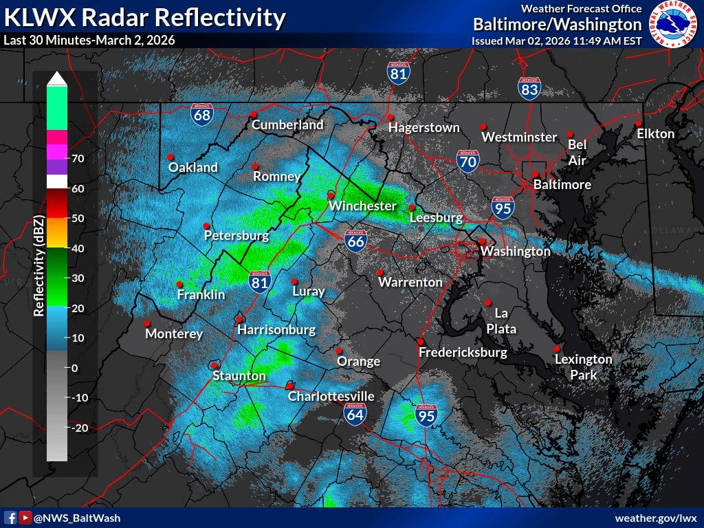
At noon Monday, a narrow band of snow was moving across areas along and south of VA-7 heading into the afternoon. Light accumulations have been observed on elevated//grassy surfaces west of Leesburg, Virginia, the NWS said. Additional snow is pushing east for the evening commute.
Find out what's happening in Anne Arundelfor free with the latest updates from Patch.
The Washington Post's Capital Weather Gang predicts temperatures mainly in the mid-30s during the day, but drivers should watch for slushy roads if there are any heavier bursts of snow.
"Wet snow tapers off this evening. After midnight, freezing rain, possibly starting as snow and sleet, develops," the Post forecast. "Freezing rain changes to plain rain by sunrise Tuesday near and east of Interstate 95 and midmorning or so elsewhere. Then a big warmup Wednesday into the weekend but with showers at times."
Find out what's happening in Anne Arundelfor free with the latest updates from Patch.
Here's the latest Maryland forecast from the National Weather Service:
Monday: Snow likely, mainly after 2pm. Cloudy, with a high near 36. Southeast wind 5 to 7 mph. Chance of precipitation is 60%. Total daytime snow accumulation of less than a half inch possible.
Monday Night: A chance of snow before 3am, then snow likely, possibly mixed with freezing rain between 3am and 4am, then rain, snow, and freezing rain likely after 4am. Cloudy, with a low around 31. Calm wind. Chance of precipitation is 70%. Little or no ice accumulation expected. New snow accumulation of less than a half inch possible.
Tuesday: Rain, possibly mixed with snow, becoming all rain after 10am. Patchy fog between 1pm and 3pm. High near 44. Light and variable wind. Chance of precipitation is 80%. New snow accumulation of less than a half inch possible.
Tuesday Night: Rain. Low around 44. Light southwest wind. Chance of precipitation is 80%. New precipitation amounts between a tenth and quarter of an inch possible.
Wednesday: A chance of rain. Cloudy, with a high near 57. Light and variable wind. Chance of precipitation is 50%.
Wednesday Night: A chance of rain. Cloudy, with a low around 49. Chance of precipitation is 50%.
Thursday: A chance of rain after 1pm. Mostly cloudy, with a high near 69. Chance of precipitation is 30%.
Thursday Night: A chance of rain. Mostly cloudy, with a low around 55. Chance of precipitation is 40%.
Friday: A chance of rain. Partly sunny, with a high near 68. Chance of precipitation is 30%.
Friday Night: Mostly cloudy, with a low around 50.
Saturday: A chance of rain. Mostly cloudy, with a high near 68. Chance of precipitation is 30%.
Saturday Night: A chance of rain. Mostly cloudy, with a low around 57. Chance of precipitation is 40%.
Sunday: A chance of rain. Partly sunny, with a high near 71. Chance of precipitation is 40%.
Get more local news delivered straight to your inbox. Sign up for free Patch newsletters and alerts.