Weather
Hurricane Dorian In Maryland: Latest Updates On Storm
Tropical storm warnings have been issued in five Maryland counties as Hurricane Dorian's impacts are projected to reach the Chesapeake Bay.


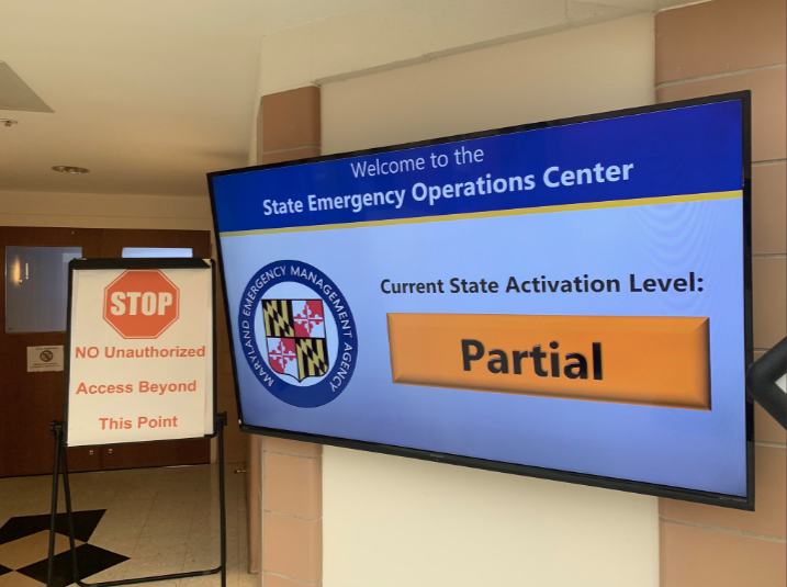
MARYLAND — With two areas of the state under separate tropical storm warnings, the Maryland Emergency Management Agency ramped up efforts to prepare for Hurricane Dorian, raising its activation level to "partial." The move was made due to Hurricane Dorian's potential impact on the lower Eastern Shore in particular, according to officials.
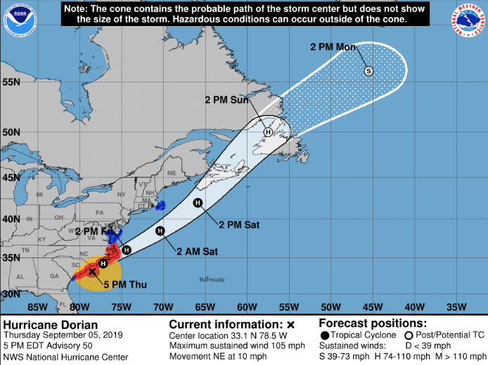
Hurricane Dorian was about 45 miles south-southeast of Mrytle Beach, South Carolina, at 5 p.m. on Thursday, Sept. 5. It was moving north-northeast at 10 mph with maximum sustained winds of 105 mph. The National Hurricane Center reported it was 460 miles south-southwest of Ocean City at noon.
The Maryland State Highway Administration reported Thursday afternoon that its crews were inspecting and clearing drainage inlets and drainage ditches ahead of the storm, in addition to readying "road closed" signs, chainsaws and wood chippers.
Find out what's happening in Baltimorefor free with the latest updates from Patch.
SEE ALSO: Hurricane Dorian In Ocean City: Flood Risks, Warnings
The center of Hurricane Dorian will near the South Carolina coast Thursday night, then approach or move over the coast of North Carolina overnight into Friday, the National Hurricane Center reported at 5 p.m. Thursday. According to the forecast track, it is likely to move southeast of extreme southeastern New England Friday night and Saturday morning, approaching Nova Scotia by Saturday night. It will likely weaken and become a "hurricane-force post-tropical cyclone" by the time it is heading for Nova Scotia, forecasters said.
Find out what's happening in Baltimorefor free with the latest updates from Patch.
How To Prepare For Hurricane Dorian:
- Know Your Zone ahead of time. These are evacuation zones in the event of a hurricane.
- Turn around; don't drown. If you see standing water of an unknown depth, do not drive through it.
- Gather emergency supplies. (Items to include: First aid kit. Medication. Batteries. Flashlight. Phone and charger; try to charge ahead of time. Three days' worth of nonperishable food per person. Pet essentials. Important documents in a waterproof bag. One gallon of water per person per day for a three-day period.)
- Make a family communications plan.
Tropical Storm Warnings
Five Maryland counties — Dorchester, Somerset, St. Mary's, Wicomico and Worcester —are under tropical storm warnings.
A tropical storm warning means that tropical storm conditions are expected within the warning area within 36 hours. Tropical storm-force winds are 39 to 73 mph.
There are two warnings: One covers the Maryland beaches and another is for St. Mary's County.
Maryland Beaches
Weather officials ramped up rainfall projections for Maryland beaches in Thursday morning's forecast, indicating the increased threat of flooding to the lower Eastern Shore. Ocean City was the spot that could be impacted the most, officials said.
"Town of Ocean City personnel have begun completing pre-storm action items, including closing the seawall and removing items from the beach. Residents are encouraged to begin securing outdoor furniture, grills and water vessels," according to a statement the town of Ocean City released around 11:30 a.m. Thursday.
"Ocean City Emergency Services is continuing to monitor the projected path of Hurricane Dorian," the statement said. "Currently, effects of the storm are expected in the Ocean City area beginning late Thursday, September 5, and lasting approximately 24 hours."
The threats to Ocean City include flooding rain and damaging winds.
"Prolonged rain and sustained winds of 30-35 miles per hour are expected, along with moderate flooding during high tide cycles," Ocean City officials reported.

Here are the potential threats and impacts, according to the National Weather Service:
FLOODING RAIN
Rainfall amounts over the Virginia Eastern Shore are forecast to range from 3 to 6 inches, while Ocean City may see 1 to 3 inches, with locally higher amounts.
Flash flooding is possible from late Thursday night through Friday afternoon.
"Heavy rainfall may prompt a few evacuations," officials said.
POTENTIAL THREAT TO LIFE AND PROPERTY: Potential for localized flooding rain. The flooding rain threat has increased from the previous assessment.
PREPARE: Consider protective actions if you are in an area prone to flooding.
POTENTIAL IMPACTS: Localized flooding from heavy rainfall may prompt a few evacuations. Rivers and tributaries may quickly rise with swift currents. Small streams, creeks, and ditches may become swollen and overflow. Flood waters may enter a few structures, especially in usually vulnerable spots. Rapid ponding of water is possible at underpasses, low-lying spots and poor drainage areas. Some storm drains and retention ponds could become nearly full and begin to overflow. Some brief road and bridge closures can be expected. Minor to moderate river flooding is possible Friday and into the weekend, especially for smaller rivers and creeks.
STORM SURGE
There is potential for 1 to 3 feet of storm surge above ground within surge-prone areas. Storm surge refers to ocean water pushed toward shore by winds that surround a hurricane.
"Life-threatening storm surge and dangerous winds are expected along portions of South Carolina and North Carolina, and portions of southeast Virginia and the southern Chesapeake Bay, regardless of the exact track of Dorian's center," according to the National Hurricane Center. "Water levels could rise well in advance of the arrival of strong winds."
The window of concern for Ocean City runs from early Friday morning until Saturday morning.
POTENTIAL THREAT TO LIFE AND PROPERTY: Potential for storm surge flooding greater than 1 foot above ground. The storm surge threat increased from the previous assessment. Widespread storm surge flooding of vulnerable areas will result in an elevated threat of property damage to homes and businesses near the waterfront and shoreline.
PREPARE: Complete preparations for storm surge flooding, especially in low-lying vulnerable areas, before conditions become unsafe. Leave immediately if evacuation orders are given for your area. Know your evacuation zone.
"Storm surge is the leading killer associated with tropical storms and hurricanes!" the National Weather Service advised in guidance for Maryland and Virginia Thursday morning. "Make sure you are in a safe area away from the surge zone. Even if you are not in a surge-prone area, you could find yourself cut off by flood waters during and after the storm."
POTENTIAL IMPACTS: Damage to homes and businesses near the waterfront and shoreline is possible. Minor to moderate damage to marinas, docks, boardwalks and piers is likely. A few small craft may break away from moorings. Sections of low-lying vulnerable roads, parking lots and property will likely become flooded. Driving conditions could become dangerous in places where flooding covers the road. Moderate to severe beach erosion is likely, including heavy surf possibly breaching dunes, especially in vulnerable locations. Strong and dangerous rip currents are likely.
TROPICAL STORM-FORCE WIND
Peak wind forecasts call for 30 to 40 mph with gusts up to 55 mph from Friday morning to Friday evening. There is potential for 39 to 57 mph winds.
PREPARE: Wrap up efforts to protect property (such as securing unanchored objects outside) as soon as possible. Be ready to move to safe shelter before the wind becomes hazardous.
POTENTIAL IMPACTS: Damage to porches, awnings, carports, sheds and unanchored mobile homes. Unsecured lightweight objects may be blown about. Many large tree limbs may break, with a few trees snapped or uprooted, especially if soils are saturated. Some road signs will sustain damage. A few roads will be impassable from debris. Hazardous driving conditions may occur on bridges and other elevated roadways. Scattered power and communications outages are possible.
HIGH RIP CURRENT RISK: Breaking waves of 5 to 7 feet will result in rough surf conditions and a high risk of rip currents Thursday.
"A high threat of rip currents will continue for all area beaches and it is advised to stay out of the water," the National Hurricane Center advised.
St. Mary's County
"The center of Hurricane Dorian is expected to pass well southeast of Point Lookout, MD, Friday afternoon. However, there is the potential for hazardous impacts to extend into Saint Mary's County and adjacent waters," according to the local hurricane statement from the National Weather Service's Baltimore-Washington office.
Of particular concern is tidal flooding.
"There is the potential for strong winds to spread onshore beginning Friday morning continuing through Friday night," the statement said. "Onshore winds ahead of Dorian are expected to raise water levels along the shores of the Chesapeake Bay and lower tidal Potomac River. Minor tidal flooding is expected. Moderate tidal flooding of shoreline areas is possible, especially on Saturday."
The "biggest tidal flood concern will be Saturday and Saturday night," the National Weather Service reported in a forecast out of the Sterling, Virginia, office. "After Dorian pulls away, winds turn northwest and lighten substantially. Local research has shown that this often causes whatever tidal anomaly exists in the lower Chesapeake Bay to push all the way up the tidal zone, and model guidance (including probabilistic guidance) is showing this."
Those in coastal areas should monitor the situation over the next few days. Officials said it was "too early to say" what could happen.
"Based on longer-range guidance, minor flooding everywhere looks fairly likely, with moderate flooding possible (especially in a worst-case scenario)," officials said. "This is something all coastal interests should continue to monitor over the next couple days."
HAZARDOUS WINDS: Peak winds are forecast to be 20 to 30 mph with gusts up to 40 mph in St. Mary's County.
IMPACTS: Damage may affect porches, awnings, carports and sheds. Unsecured lightweight objects could be blown about. Many large tree limbs may be broken off and a few trees snapped or uprooted, but with greater numbers in places where trees are shallowly rooted. Some fences and roadway signs may blow over. A few roads could be impassable from debris, particularly within urban or heavily wooded places. Hazardous driving conditions on bridges and other elevated roadways are possible, as are scattered power and communications outages.
PREPARE: Efforts to protect property should now be underway.
Rainfall will likely reach southern Maryland, but "flooding from rainfall is not expected at this time," according to the local hurricane statement for St. Mary's County.
UPDATE: Storm surge threat has decreased in St. Mary's County, the National Weather Service reported after 11 a.m. "Little to no storm surge flooding through Friday" is expected in St. Mary's County, according to the warning.
Get more local news delivered straight to your inbox. Sign up for free Patch newsletters and alerts.