Weather
Air Quality Alert Issued For 7 MD Jurisdictions; Storms Possible
The air quality may be unhealthy for certain people on Monday, Aug. 9, officials advise. Temperatures this week may also be excessively hot.


MARYLAND — The Baltimore metropolitan area is under a "code orange" air quality alert Monday, according to authorities. Six counties and Baltimore City are included in the alert Monday. In addition, the National Weather Service has issued a hazardous weather outlook for central Maryland and the Eastern Shore as the potential for excessive heat is on the horizon later this week.
The Maryland Department of the Environment declares air quality "code orange" when pollution concentrations may be unhealthy for sensitive groups. Children, older adults, heart/lung disease sufferers and asthmatics are considered sensitive.
To minimize the effects from the air quality, officials advise avoiding outdoor and strenuous activities.
Find out what's happening in Baltimorefor free with the latest updates from Patch.
These areas are under the air quality alert Monday, Aug. 9:
- Anne Arundel County
- Baltimore City
- Baltimore County
- Carroll County
- Cecil County
- Harford County
- Howard County
Visit the www.mde.state.md.us/air or call 410-537-3000 to get more information about air quality.
Find out what's happening in Baltimorefor free with the latest updates from Patch.
A chance of rain Monday afternoon and early evening may include a slow-moving thunderstorm that could lead to isolated flooding in the Baltimore-Washington area and gusty winds on the water, according to a hazardous weather outlook from the National Weather Service.
Temperatures this week are supposed to hit daytime highs in the 90s and are likely to increase each day.
The National Weather Service issued a hazardous weather outlook calling for heat indices of 100 to 105 degrees during the afternoons Wednesday through Friday in the Baltimore-Washington area.
"Isolated severe storms along with isolated instances of flash flooding are possible during the afternoon and evening hours Wednesday through Saturday" as well, officials said.
A separate hazardous weather outlook for the Eastern Shore states that hot conditions Wednesday and Thursday could result in heat exhaustion if people are exposed to the heat for long periods.
Here is the forecast for the Baltimore-Washington region this week from the National Weather Service:
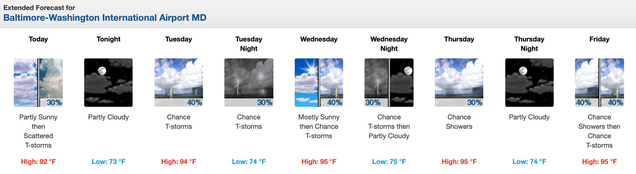
Temperatures could peak at the end of the week with heat indices above 100 degrees in Maryland. Nighttime temps are slated to be in the low to mid-70s.
Get more local news delivered straight to your inbox. Sign up for free Patch newsletters and alerts.