
BALTIMORE, MD — While Wednesday's weather had Marylanders thinking of summer, it was too good to be true. High temperatures will actually remain above normal for the next week, but we've got some dreary weather on the way.
The sun is going on hiatus until Monday, with rain and clouds in the forecast every day through the weekend.
After two days of record warmth — Tuesday tied the highest temp on record at BWI and Wednesday set a new one — temperatures are expected to drop significantly in a 24-hour period.
Find out what's happening in Baltimorefor free with the latest updates from Patch.
Weather officials say that after Wednesday's record high of 79 degrees, temperatures will sink into the upper 30s by Thursday evening. That's a drop of 40 degrees.
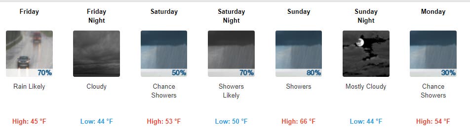
But warmer temperatures will return. Highs will be in the 40s on Friday, the 50s on Saturday and the upper 60s on Sunday, according to the National Weather Service. Here is what it will look like in the region:
Find out what's happening in Baltimorefor free with the latest updates from Patch.
Temperatures had already dropped off significantly by 11 a.m. on Thursday, the weather service reported.

Want to bask in the record warmth one more time?
Take a look at Wednesday's record-breaking temps, when weather officials said BWI hit 79 degrees, shattering the previous record of 74 degrees from Feb. 21 in 1930.
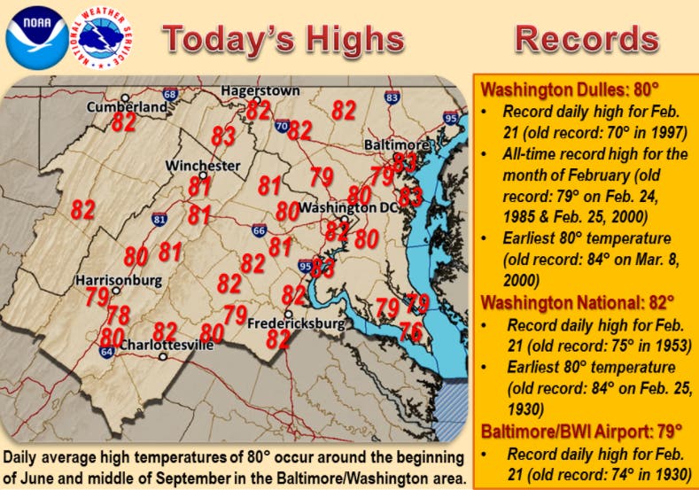
On Tuesday, authorities reported BWI tied the record of 76 degrees set on Feb. 20, 1930.
So no, it was not just you; Tuesday and Wednesday were extremely hot for February.
During a time when the National Weather Service says temps are usually between the 20s and 40s, it felt like early June or the middle of September in the Baltimore-Washington area.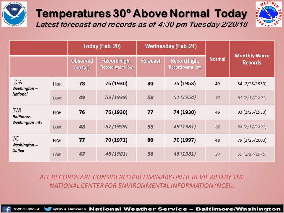
They say in Maryland that if you don't like the weather, wait a minute. So be forewarned, the region is not off the hook for wintry weather.
"While the colder air slated for early March will not pack the punch of early January, it may get cold enough for more storms to come about with snow," AccuWeather Senior Meteorologist Dale Mohler says.
The forecast:
Friday, Feb. 23
Light rain in the morning. High 47, low 39.
Chance of precipitation: 81%. Wind 4 mph from the ESE
Saturday, Feb. 24
Overcast throughout the day. High 53, low 48.
Chance of precipitation: 65%. Wind 3 mph from the NE
Sunday, Feb. 25
Rain in the morning. High 67, low 46.
Chance of precipitation: 93%. Wind 4 mph from the S
Monday, Feb. 26
Mostly cloudy until afternoon. High 58, low 45.
Chance of precipitation: 7%. Wind 10 mph from the WNW
— By Ryan Bonner and Elizabeth Janney
Graphics/tables courtesy of the National Weather Service. Cloud photo via Shutterstock.
Get more local news delivered straight to your inbox. Sign up for free Patch newsletters and alerts.