Weather
Heat Index To Top 100 Degrees In Maryland, Advisory Issued
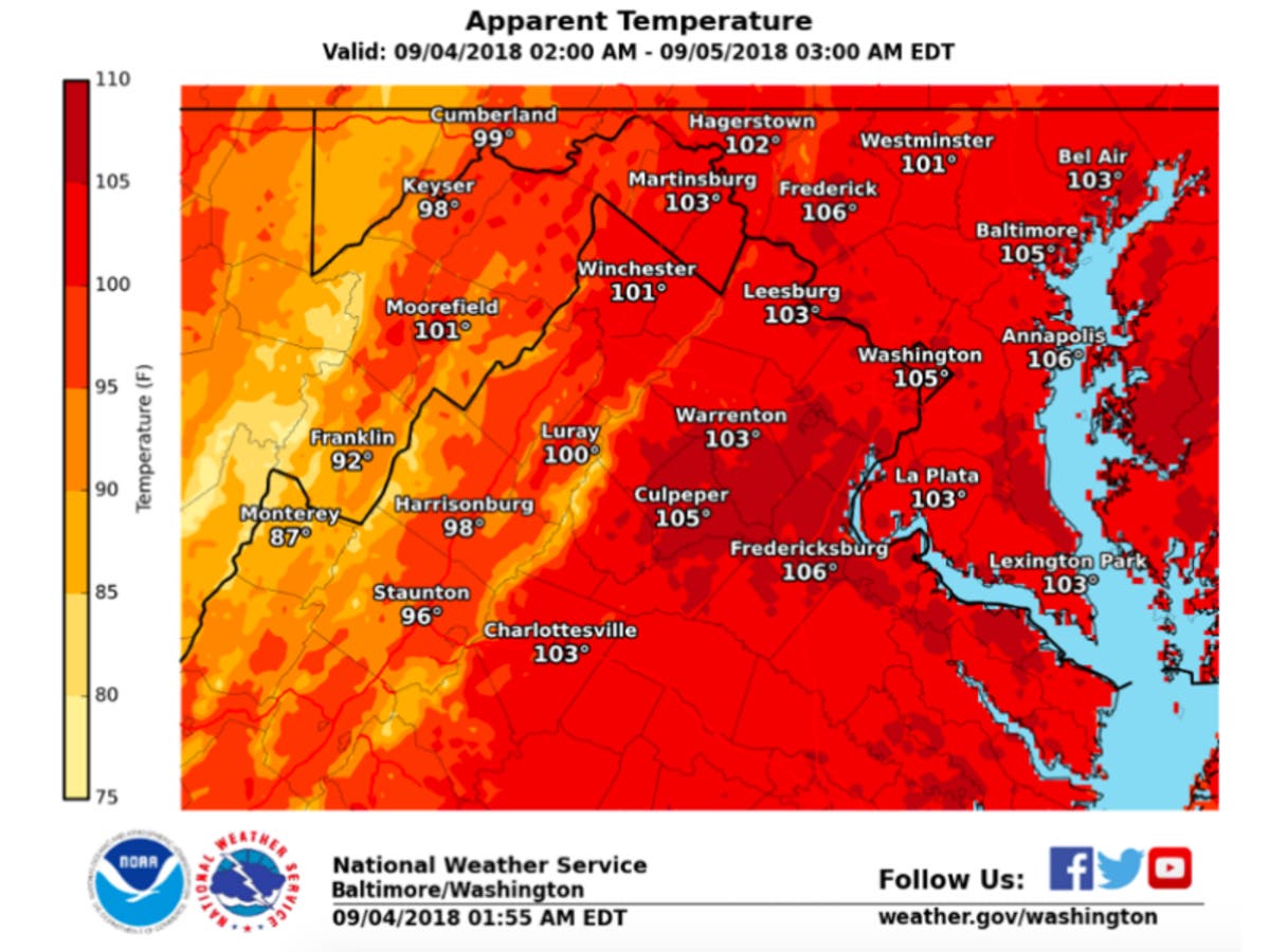
Dangerous heat is in the forecast for Maryland on Tuesday, Sept. 4, according to the National Weather Service, and it may continue for days.

MARYLAND — If you thought Labor Day was hot, you might want to stay inside on Tuesday. The mercury is rising, and it's only going up. And Tuesday isn't the only scorcher, as the National Weather Service predicts high temperatures will not drop below the 90s until Friday.
Temps are expected to hit around 105 degrees on the heat index Tuesday, with actual temperatures in the mid 90s.
The heat index — how hot it feels with humidity factored in — may also rise to triple digits Wednesday and Thursday, with 100 to 105 degrees forecast.
Find out what's happening in Baltimorefor free with the latest updates from Patch.
Due to the heat, 10 schools were closed in Baltimore County Tuesday for the first day of school since they lack air-conditioning; and more than 60 Baltimore City schools are dismissing early because of the heat as well.
A heat advisory is in effect from noon to 7 p.m. on Tuesday for much of Maryland. The advisory means high temperatures and high humidity may create a situation in which heat-related illnesses could occur. To avoid becoming ill, reschedule strenuous activities to the early morning or evening; drink water; and wear loose, light-fitting clothing. Those working outside should take frequent breaks in shade or air-conditioning.
Find out what's happening in Baltimorefor free with the latest updates from Patch.
These areas are under the heat advisory from noon until 7 p.m. on Tuesday, Sept. 4:
- Anne Arundel County
- Baltimore City
- Baltimore County
- Calvert County
- Caroline County
- Charles County
- Frederick County
- Harford County
- Howard County
- Kent County
- Montgomery County
- Prince George's County
- Queen Anne's County
- St. Mary's County
- Talbot County
The District of Columbia and parts of Virginia are also included in the heat advisory.
How To Stay Safe In The Heat
Anyone overcome by heat should be moved to a cool and shaded location.
Cooling centers are open in Baltimore City, Baltimore County and Harford County.
Heat stroke, the most serious heat-related illness, can be fatal if not treated immediately.
It occurs when the body's temperature rises rapidly and the sweating mechanism fails, leading to overheating without a way to cool down.
If someone exhibits signs of heat-related illness, move the person to a cool, shaded area and call 911. Here are the symptoms of heat stroke: confusion; slurred speech; seizures; hot, dry skin or extreme sweating; altered mental status; very high body temperature; and loss of consciousness/coma.
Here are several ways to stay safe during the heat advisory period:
- Lighten up. Wear lightweight, light-colored clothing. Light colors reflect away some of the sun's energy. It is also a good idea to wear hats or to use an umbrella.
- Drink water. Carry water or juice with you and drink continuously even if you don't feel thirsty. Avoid alcohol and caffeine, which dehydrate the body. Avoid salt tablets unless directed by a physician.
- Eat small meals and eat more often. Avoid high-protein foods, which increase metabolic heat.
- Slow down. Avoid strenuous activity. If you must do strenuous activity, do it during the coolest part of the day, which is usually in the morning between 4 and 7 a.m.
- Stay inside. If air-conditioning is not available, go to the lowest floor out of the sunshine. Remember that electric fans do not cool; they simply circulate the air.
- Be a good neighbor. During heat waves, check in on elderly residents in your neighborhood and those who do not have air conditioning.
Here is the forecast for the rest of the week
Tuesday: Heat index values around 103 degrees. Light wind. Chance of precipitation is 20%. Low of 75.
Wednesday: Heat index values as high as 102 degrees. Patchy fog before 9 a.m. Showers/thunderstorms possible after 2 p.m., with 20% chance of rain. Mostly sunny, with a high near 94 and low of 74 degrees.
Thursday: Chance of precipitation increases to 40 percent, with thunderstorms most likely after noon. Temps will top out at 94 degrees and go down to 73 at night.
Friday: Chance of precipitation is 50% as temps drop to a high of 85 degrees. Mostly cloudy. Low of 69.
Saturday: Mostly cloudy, with a high near 77. Chance of precipitation is 60%. Low of 66.
Sunday: Cloudy, with a high near 78. Showers likely and possibly a thunderstorm; there is a 60% chance of precipitation. Low around 68.
— Forecast from the National Weather Service
Graphic courtesy of the National Weather Service.
Get more local news delivered straight to your inbox. Sign up for free Patch newsletters and alerts.