Weather
Hurricane Dorian: When It Could Hit Maryland
Here is what forecasters are saying about the potential impact Hurricane Dorian could have on Maryland.

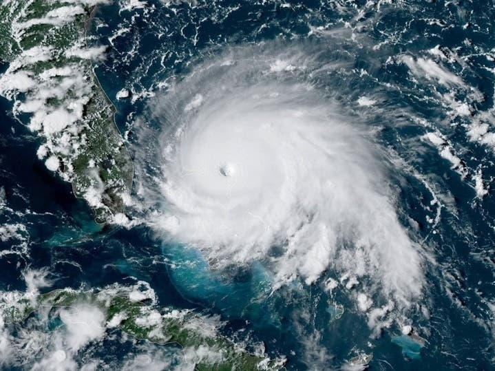
MARYLAND — Hurricane Dorian barreled through the Bahamas with 185 mph winds, and forecasters say Maryland may experience tropical storm-force winds later in the week. Officials with the National Hurricane Center described category 4 Dorian as a "catastrophic hurricane" that will likely remain life-threatening for several days.
"Now is the time to make sure you have a disaster supply kit and an emergency plan," the Maryland Emergency Management Agency tweeted.
As of Monday afternoon, Hurricane Dorian was about 105 miles east of West Palm Beach, Florida. The storm is stalling over the Bahamas — moving west at 1 mph, National Hurricane Center officials reported Monday, Sept. 2, with sustained winds of 150 mph.
Find out what's happening in Baltimorefor free with the latest updates from Patch.
SEE TUESDAY'S UPDATE: 'Do Not Focus On The Track Alone'
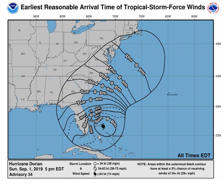
Later this week, Maryland may feel the effects from Dorian, the National Weather Service advised. The storm may deliver tropical storm-force winds to Maryland shores by Thursday, Sept. 5, based on projections issued Monday, which are subject to change. Tropical storm-force winds are defined as those 39 to 73 mph.
Find out what's happening in Baltimorefor free with the latest updates from Patch.
Alerts are in place for Labor Day beach-goers in Maryland and Virginia due to waves that may be 3 to 4 feet above normal; the National Weather Service issued statements about beach hazards because of rough surf conditions and a high risk of rip currents, effective from 8 a.m. to 8 p.m. Monday, Sept. 2.
The Eastern Shore may experience heavy rain after 2 p.m. Thursday, according to the forecast from the National Weather Service. Tropical storm conditions are possible Thursday night, followed by strong winds Friday.
"There is a potential for direct impacts from the storm in the form of heavy rain, wind and coastal flooding, depending on the exact track of the system," according to a hazardous weather outlook for Ocean City that says the storm may "lift north and northeast along the Southeast coast late this week."
The hurricane would likely reach Maryland days after it first hit land as a catastrophic storm hundreds of miles away.
Hurricane Dorian struck the Abaco Islands in the northwestern Bahamas Sunday as a Category 5 storm. It made landfall on Elbow Cay first at 12:45 p.m., then hit Great Abaco Island near Marsh Harbour at 2 p.m., with maximum sustained winds of 185 mph in both cases. With speeds that great, it tied the 1935 Labor Day hurricane for the strongest Atlantic hurricane landfall on record, according to the National Hurricane Center.
Storm surges brought the tides 18 to 23 feet above normal in the Bahamas, the center reported, a danger that could continue should the storm turn north.
A hurricane warning was issued Sunday evening for part of Florida's east coast, and evacuations were underway after mandatory orders were given in multiple counties.
Ahead of the storm making landfall, a team of urban search and rescue personnel deployed from Maryland Friday to assist the Federal Emergency Management Agency (FEMA) with efforts in Florida. Maryland Gov. Larry Hogan said the state was ready to help Floridians, and the Maryland Emergency Management Agency was keeping an eye on the storm.
While after three days, there may be a "weakening trend," the National Hurricane Center advised Sunday that Dorian is likely to remain a hurricane for the next five days.
"There is an increasing likelihood of strong winds and dangerous storm surge along the coasts of Georgia, South Carolina, North Carolina later this week," the National Hurricane Center stated in its 5 p.m. Sunday forecast discussion. "Heavy rains, capable of producing life-threatening flash floods, are expected over northern portions of the Bahamas and coastal sections of the southeast and lower mid-Atlantic regions of the United States through late this week."
Forecast For Central Maryland
Here is the forecast for the Baltimore area, according to the National Weather Service.
Labor Day: A slight chance of showers, then scattered showers and thunderstorms after 2pm. Mostly cloudy, with a high near 85. South wind around 7 mph. Chance of precipitation is 40%.
Monday Night: Scattered showers and thunderstorms before 11pm, then a chance of showers between 11pm and 2am. Mostly cloudy, with a low around 68. Southwest wind around 5 mph becoming calm after midnight. Chance of precipitation is 40%.
Tuesday: Sunny, with a high near 86 and low of 71. North wind around 5 mph becoming calm in the afternoon.
Tuesday Night: Mostly clear, with a low around 71. Southeast wind around 6 mph.
Wednesday: A slight chance of showers, then a chance of showers and thunderstorms after 2pm. Mostly sunny, with a high near 91. Southwest wind 7 to 10 mph. Chance of precipitation is 30%.
Wednesday Night: A chance of showers and thunderstorms. Mostly cloudy, with a low around 68. Chance of precipitation is 40%.
Thursday: A chance of showers. Mostly cloudy, with a high near 76. Chance of precipitation is 40%.
Thursday Night: A chance of showers. Mostly cloudy, with a low around 64. Chance of precipitation is 30%.
Friday: A chance of showers. Partly sunny, with a high near 74. Chance of precipitation is 30%.
Friday Night: Partly cloudy, with a low around 61.
Saturday: Sunny, with a high near 81.
Saturday Night: Mostly clear, with a low around 63.
Sunday: Mostly sunny, with a high near 79.
RELATED:
Get more local news delivered straight to your inbox. Sign up for free Patch newsletters and alerts.