Weather
Map Shows Parts Of MD Most Likely To Be Hit By Weekend Winter Storm
Forecasters are also monitoring a chance for light snow on Wednesday that could impact the afternoon commute. See the latest MD forecast.

Forecasters are continuing to monitor another winter storm that could affect Maryland and bring snow and gusty winds to the Baltimore region this weekend. There's also a chance the area could see snow on Wednesday, potentially impacting the afternoon commute, according to the latest forecasts.
A storm is expected to strengthen along a stalled front near the Gulf Coast late this week, with precipitation potentially beginning as early as Friday across portions of the Southeast before shifting east and north into the weekend, AccuWeather wrote in its latest forecast.
In a separate forecast, the National Weather Service's Weather Prediction Center said confidence is increasing for impactful snow in the Carolinas and southern Virginia. At the same time, significant snowfall chances remain lower in Maryland and north along the East Coast.
Find out what's happening in Baltimorefor free with the latest updates from Patch.
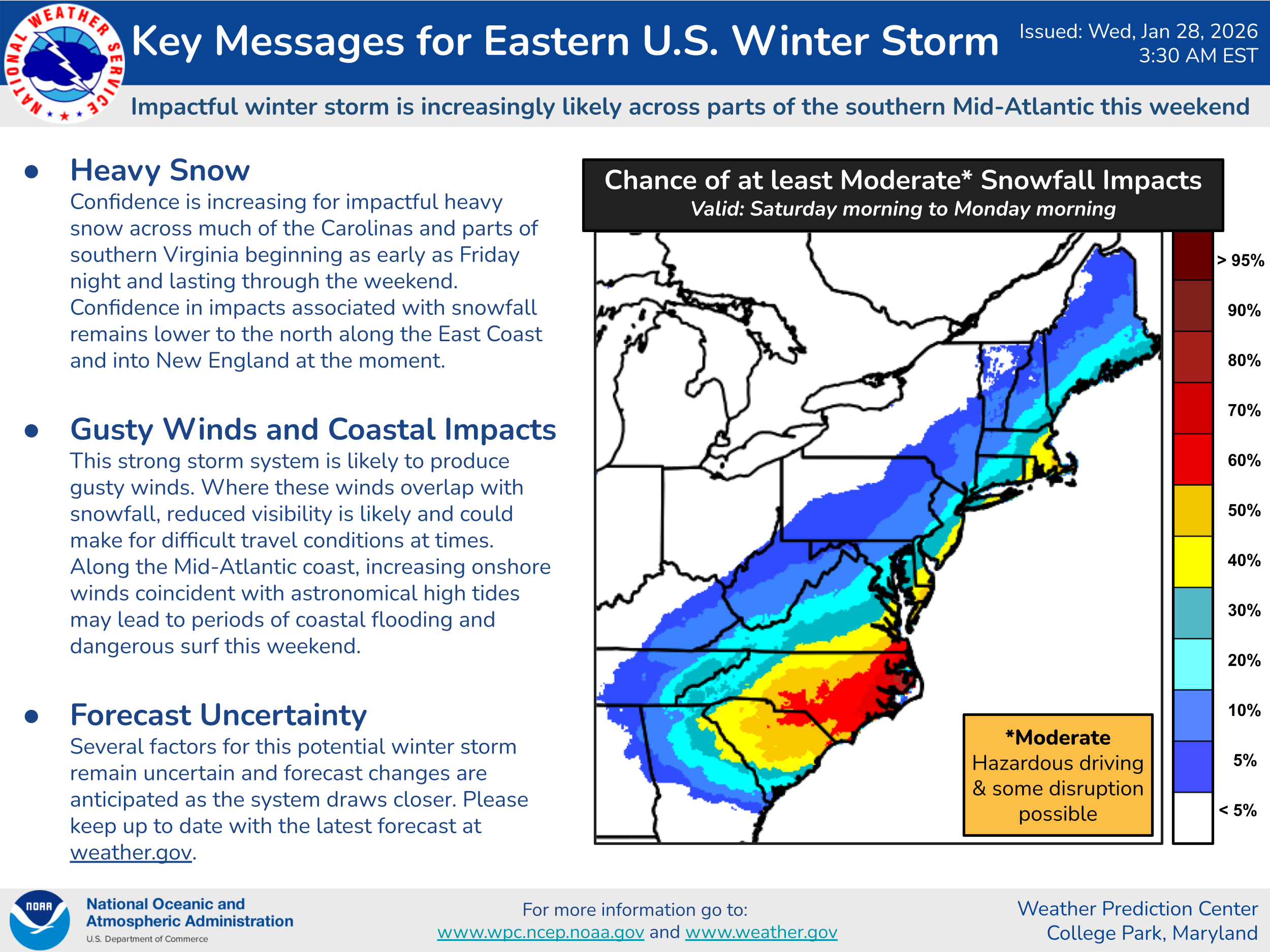
AccuWeather forecasters predict the Baltimore region has a 20 to 40 percent chance of getting 3 or more inches of snow, and less than a 20 percent chance of 6 inches or more.
The storm system is also likely to produce strong winds. Combined with the snow, reduced visibility is likely and could make travel hazardous. Along the Maryland coast, winds combined with high tides may lead to coastal flooding and dangerous surf conditions.
Find out what's happening in Baltimorefor free with the latest updates from Patch.
"Several factors for this potential winter storm remain uncertain and forecast changes are anticipated as the system draws closer," the Weather Prediction Center wrote.
.jpg)
Meanwhile, bitterly cold temperatures are expected to linger well into next week with wind chill values falling below zero on occasion. A cold weather advisory once again goes into effect on Wednesday at 7 p.m. The advisory expires at 11 a.m. on Thursday.
Also, forecasters said there's a 20 to 30 percent chance the Baltimore region could see some light snow move through the area from northwest to southeast later Wednesday afternoon into this evening.
"If the snow occurs, a coating of around a half an inch could be possible during the PM commute," forecasters wrote.

Here's a look at the latest National Weather Service forecast for the region:
Wednesday: A slight chance of snow after 2pm. Mostly cloudy, with a high near 21. West wind 6 to 8 mph. Chance of precipitation is 20%.
Wednesday Night: A slight chance of snow before 10pm. Mostly cloudy, then gradually becoming mostly clear, with a low around 8. Wind chill values as low as -2. Calm wind becoming west around 6 mph after midnight. Chance of precipitation is 20%.
Thursday: Sunny, with a high near 22. Wind chill values as low as -1. West wind 6 to 10 mph, with gusts as high as 18 mph.
Thursday Night: Mostly clear, with a low around 8. Northwest wind 3 to 6 mph.
Friday: Mostly sunny, with a high near 20. Northwest wind 3 to 7 mph.
Friday Night: Partly cloudy, with a low around 8.
Saturday: Partly sunny, with a high near 18.
Saturday Night: A chance of snow after 1am. Mostly cloudy, with a low around 13. Chance of precipitation is 30%.
Sunday: A chance of snow before 1pm. Partly sunny, with a high near 26. Chance of precipitation is 30%.
Sunday Night: Partly cloudy, with a low around 17.
Monday: Mostly sunny, with a high near 32.
Get more local news delivered straight to your inbox. Sign up for free Patch newsletters and alerts.