Weather
Severe Storms To Target MD Thursday: See Timing, Forecast
A heat advisory is in effect for portions of Maryland on Thursday, with heat index values once again reaching the triple digits.

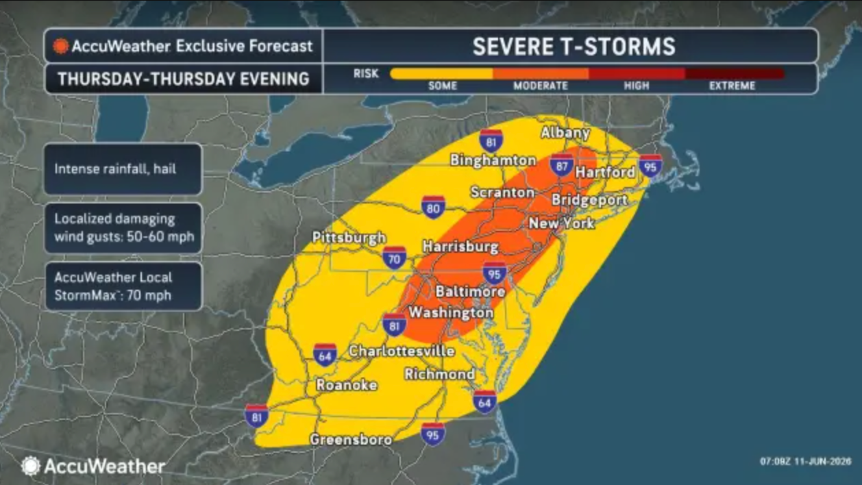
Scattered severe storms are possible across Maryland on Thursday and will accompany what forecasters are calling "record-challenging" heat in some parts of the state.
A heat advisory is in effect until 8 p.m. for areas near and east of the Interstate 95 corridor, from northeast to southern Maryland and the northern neck of Virginia, according to the National Weather Service. This includes the cities of Baltimore and Washington, D.C.
Highs in the area are likely to reach 95 degrees, with heat index values up to 105 expected.
Find out what's happening in Baltimorefor free with the latest updates from Patch.
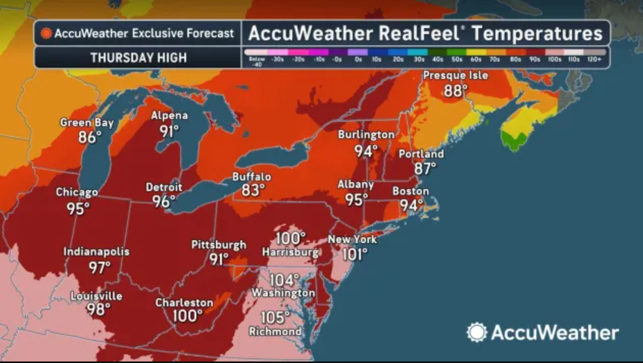
"Some daily record highs may be set for multiple days in multiple locations," AccuWeather Senior Meteorologist Brett Anderson wrote.
Find cooling centers in Maryland.
Find out what's happening in Baltimorefor free with the latest updates from Patch.
Storms on Thursday afternoon and evening could be more robust than previous days, with a greater concentration of strong wind gusts from northern Virginia to southwestern Massachusetts, according to AccuWeather.
Thursday's storms may contain damaging wind gusts and
spotty hail late this afternoon through late evening, likely between 3 p.m. and 11 p.m., NWS forecasters wrote.
"There is a small risk that thunderstorms become a bit more widespread, in which case damaging wind gusts could be a bit more numerous," the NWS said.
Friday will offer little reprieve from the heat, with temperatures remaining in the mid- to upper 90s and heat index values once again in the triple digits.
More numerous thunderstorms are likely on Friday afternoon and evening. Some of these storms may contain damaging wind gusts or large hail.
Here's a look at the detailed forecast for the Baltimore region:
Thursday: A slight chance of showers and thunderstorms after 3pm. Partly sunny, with a high near 95. Heat index values as high as 105. West wind 6 to 8 mph. Chance of precipitation is 20%.
Thursday Night: A chance of showers and thunderstorms, mainly before 11pm. Mostly cloudy, with a low around 73. West wind 3 to 5 mph. Chance of precipitation is 50%.
Friday: A slight chance of showers and thunderstorms between 3pm and 4pm, then showers likely and possibly a thunderstorm after 4pm. Mostly sunny, with a high near 96. Heat index values as high as 103. Light west wind increasing to 5 to 9 mph in the morning. Chance of precipitation is 60%. New rainfall amounts between a tenth and quarter of an inch, except higher amounts possible in thunderstorms.
Friday Night: Showers and thunderstorms likely before 11pm, then a chance of showers between 11pm and 2am. Mostly cloudy, then gradually becoming mostly clear, with a low around 68. Northwest wind around 7 mph. Chance of precipitation is 60%. New precipitation amounts between a tenth and quarter of an inch, except higher amounts possible in thunderstorms.
Saturday: Sunny, with a high near 90. Northwest wind 3 to 5 mph.
Saturday Night: Mostly clear, with a low around 68.
Sunday: A chance of showers and thunderstorms after 2pm. Partly sunny, with a high near 93. Chance of precipitation is 50%.
Sunday Night: A chance of showers and thunderstorms before 8pm, then showers likely and possibly a thunderstorm between 8pm and 2am, then a slight chance of showers after 2am. Mostly cloudy, with a low around 66. Chance of precipitation is 60%.
Monday: A slight chance of showers before 8am, then a slight chance of showers after 2pm. Partly sunny, with a high near 83. Chance of precipitation is 20%.
Get more local news delivered straight to your inbox. Sign up for free Patch newsletters and alerts.