Weather
Thunderstorms Possible For MD Before Cold Returns: Latest Forecast
Thunderstorms could bring damaging winds and hail to the Baltimore region ahead of a brief cooldown. See the latest forecast.

After several days of near-record warmth, an incoming cold front will approach Maryland on Wednesday, bringing the chance for severe weather and a brief but significant drop in temperature, according to the latest forecasts.
Ahead of any potential severe weather, the Baltimore region will once again see temperatures in the low to mid-80s on Wednesday. Some humidity is possible, forecasters said.
Meanwhile, rain and thunderstorms are predicted to move into the region later Wednesday, according to the National Weather Service.
Find out what's happening in Baltimorefor free with the latest updates from Patch.
The NWS Storm Prediction Center on Wednesday upgraded Maryland to a "slight risk" of severe thunderstorms starting Wednesday afternoon into the early evening hours. The greatest risk of severe weather will be between 5 and 8 p.m., forecasters said.
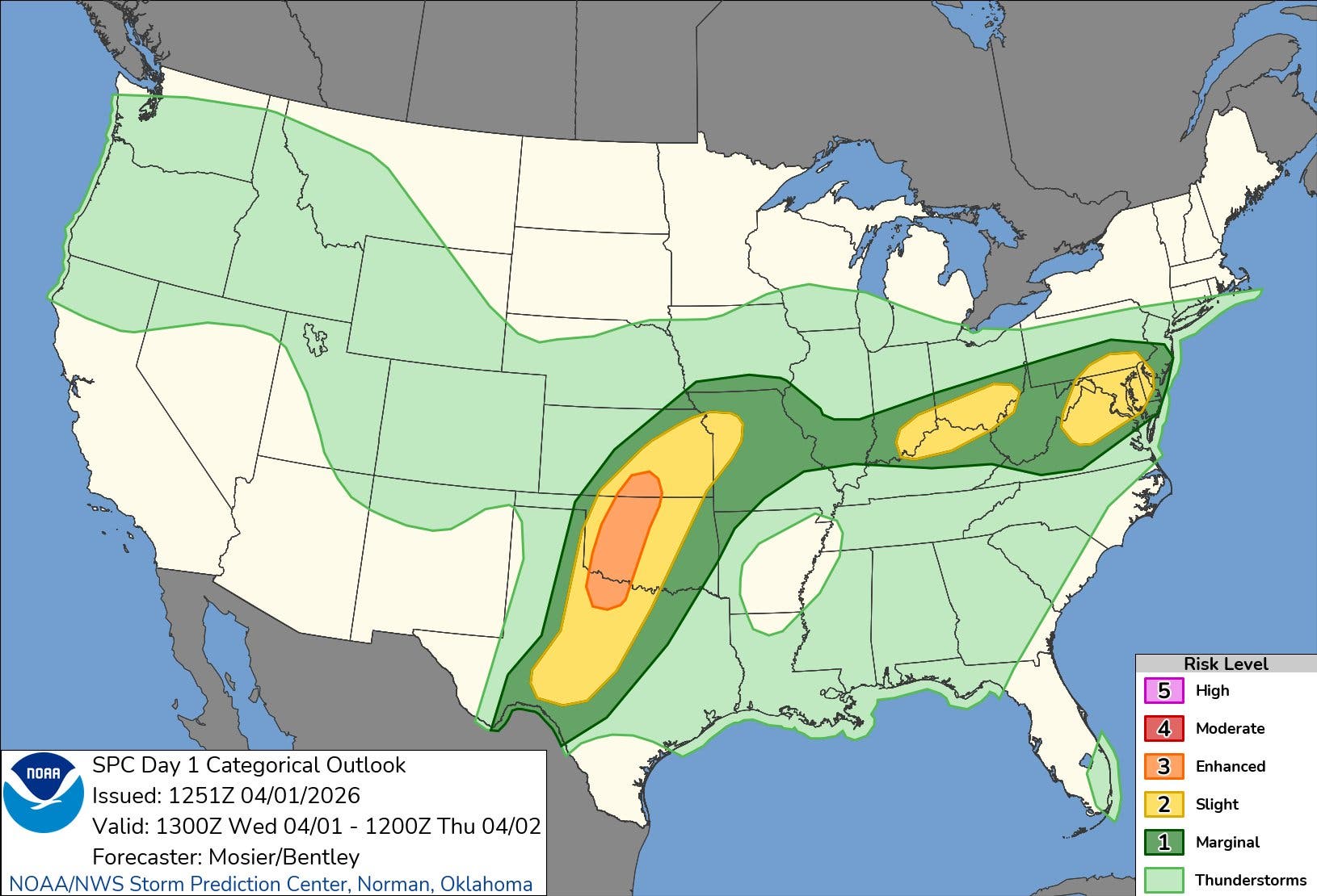
According to a hazardous weather outlook issued by the National Weather Service, the system could spawn some thunderstorms capable of producing damaging winds and hail.
Find out what's happening in Baltimorefor free with the latest updates from Patch.
Any threat of severe weather should diminish by late Wednesday night, though some showers may continue into the night, forecasters said.
On Friday, Baltimore-area residents should expect significantly cooler temperatures, though the exact forecast remains uncertain due to an incoming warm front, The Washington Post's Capital Weather Gang wrote in its latest forecast.
"The uncertain position of a warm front continues to make Thursday a tricky temperature forecast," the Capital Weather Gang wrote. "Highs could be anywhere from the upper 50s to upper 70s (coolest northeast, warmest southwest) under partly to mostly cloudy skies."
An isolated shower or thunderstorm is possible Thursday afternoon into the evening, forecasters said.
Warm air will surge back into the region on Friday, pushing highs to the upper 70s to mid-80s before another cold front approaches on Sunday.
"Highs should manage the 70s with showers and thunderstorms possible during the afternoon into the evening," the Capital Weather Gang wrote. "Behind the front, Sunday night lows cool off into the 40s."
Here's a look at the detailed NWS forecast for the Baltimore region:
Wednesday: Scattered showers and thunderstorms, then showers likely and possibly a thunderstorm after 5pm. Partly sunny, with a high near 85. West wind around 8 mph. Chance of precipitation is 60%. New rainfall amounts between a tenth and quarter of an inch, except higher amounts possible in thunderstorms.
Wednesday Night: Showers and possibly a thunderstorm, mainly before 1am, then scattered showers and thunderstorms after 1am. Patchy fog after 11pm. Low around 58. Light and variable wind. Chance of precipitation is 80%. New rainfall amounts between a quarter and half of an inch possible.
Thursday: A chance of showers between 2pm and 5pm, then a chance of showers and thunderstorms after 5pm. Patchy fog before 11am. Otherwise, mostly cloudy, with a high near 65. East wind 5 to 9 mph. Chance of precipitation is 40%.
Thursday Night: A chance of showers and thunderstorms before 8pm. Mostly cloudy, with a low around 51. East wind 5 to 9 mph becoming light after midnight. Chance of precipitation is 30%.
Friday: Mostly sunny, with a high near 81. South wind 5 to 11 mph, with gusts as high as 18 mph.
Friday Night: Partly cloudy, with a low around 62.
Saturday: Mostly sunny, with a high near 82.
Saturday Night: A chance of showers after 2am. Partly cloudy, with a low around 60. Chance of precipitation is 30%.
Sunday: Showers, mainly after 8am. High near 71. Chance of precipitation is 80%.
Get more local news delivered straight to your inbox. Sign up for free Patch newsletters and alerts.