Weather
Timeline For Storms, Hail In MD This Week: See Latest Forecast
Storms are expected to roll through the Baltimore region over the coming days as temperatures near the triple digits.

Storms are expected to roll through the Baltimore region over the coming days, producing damaging wind gusts and hail as Maryland also grapples with oppressive heat, according to the latest forecasts.
The National Weather Service is warning that storms could create hazardous conditions in Northern and Central Virginia on Wednesday, Thursday and Friday.
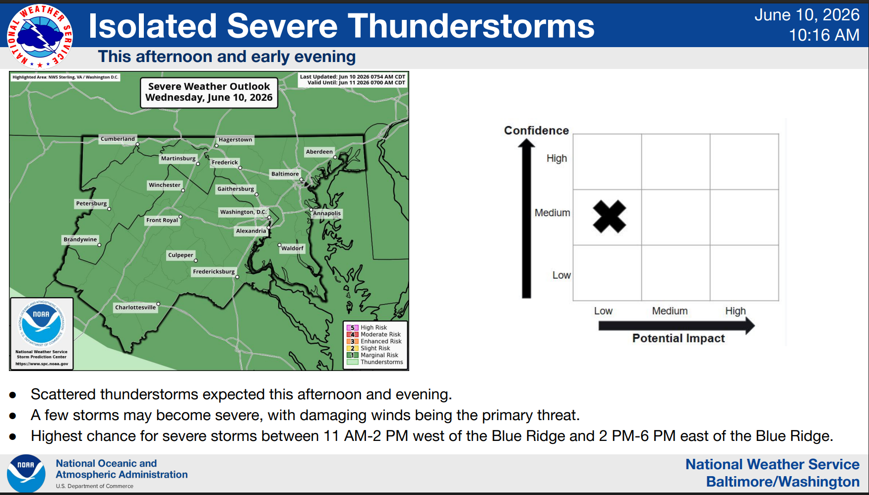
Showers and thunderstorms are predicted to roll in on Wednesday afternoon, bringing wind gusts up to 20 mph, according to the National Weather Service. These storms could produce strong to damaging winds throughout most of the Baltimore region between 3 p.m. and 7 p.m.
Find out what's happening in Baltimorefor free with the latest updates from Patch.
Wednesday night will calm down, with a slight chance of scattered showers after 4 a.m. But Thursday will bring the heat, with high temperatures from Thursday to Sunday reaching the mid-90s, with a potential heat index of 100 to 105 on some days.
Thursday night could bring more severe thunderstorms with the possibility of strong winds and sporadic large hail, mainly during the overnight hours.
Find out what's happening in Baltimorefor free with the latest updates from Patch.
On Friday afternoon and evening, numerous and possibly heavy thunderstorms are again possible, with additional chances of hail and damaging winds.
Here’s the full forecast, according to the National Weather Service.
Today: Scattered showers and thunderstorms, then showers and possibly a thunderstorm after 2 p.m. High near 87. Southwest wind 9 to 11 mph, with gusts as high as 18 mph. Chance of precipitation is 80 percent. New rainfall amounts of less than a tenth of an inch, except higher amounts possible in thunderstorms.
Tonight: Showers and thunderstorms before 9 p.m., then a slight chance of showers after 4 a.m. Low around 72. Southwest wind 5 to 7 mph. Chance of precipitation is 80 percent. New precipitation amounts of less than a tenth of an inch, except higher amounts possible in thunderstorms.
Thursday: Patchy fog before 7 a.m. Otherwise, mostly sunny, with a high near 96. Heat index values as high as 104. West wind 6 to 11 mph, with gusts as high as 18 mph.
Thursday night: A chance of showers and thunderstorms before 2 a.m. Mostly cloudy, with a low around 76. West wind 5 to 9 mph. Chance of precipitation is 30 percent.
Friday: Showers likely and possibly a thunderstorm after 2 p.m. Partly sunny and hot, with a high near 97. West wind 6 to 9 mph. Chance of precipitation is 60 percent.
Friday night: Showers and thunderstorms likely before 11 p.m., then a chance of showers between 11 p.m. and 2 a.m. Mostly cloudy, with a low around 71. Chance of precipitation is 60 percent.
Saturday: Sunny, with a high near 91.
Saturday night: Mostly clear, with a low around 69.
Sunday: Mostly sunny, with a high near 92.
Sunday night: A chance of showers between 8 p.m. and 2 a.m. Mostly cloudy, with a low around 69. Chance of precipitation is 40 percent.
Monday: A chance of showers and thunderstorms. Partly sunny, with a high near 86. Chance of precipitation is 40 percent.
Monday night: A chance of showers and thunderstorms. Mostly cloudy, with a low around 66. Chance of precipitation is 40 percent.
Tuesday: A chance of showers. Partly sunny, with a high near 84. Chance of precipitation is 30 percent.
Get more local news delivered straight to your inbox. Sign up for free Patch newsletters and alerts.