Weather
Timeline For Worst MD Heat As Heat Index Hits 105 Degrees
The sweltering heat continues on Monday and possibly Tuesday. Find out when it will be worst in central Maryland.


You may want to take that dip in the pool or in the ocean. Dangerous heat is expected to stick around in central Maryland possibly until Tuesday, according to the National Weather Service.
Weather officials have issued a heat advisory for Monday, July 2, the second consecutive day for such an alert. The advisory means the sweltering heat blanketing the region on Sunday is going to continue.
Temperatures will be in the mid to upper 90s on Monday and will feel like 105 degrees on the heat index, according to the advisory.
Find out what's happening in Baltimorefor free with the latest updates from Patch.
The heat advisory is in effect from noon to 8 p.m. on Monday, July 2, for Baltimore City and these counties in central Maryland: Anne Arundel, Baltimore, Calvert, Carroll, Charles, Frederick, Harford, Howard, Montgomery, Prince George's and St. Mary's. The District of Columbia is also included.
A heat advisory means that heat-related illnesses could occur because of the combination of humidity and temperatures.
Find out what's happening in Baltimorefor free with the latest updates from Patch.
"Today will be very hot and humid again. Heat advisories are in effect for much of the region. Please take precautions if you will be out in the heat today," the National Weather Service said.
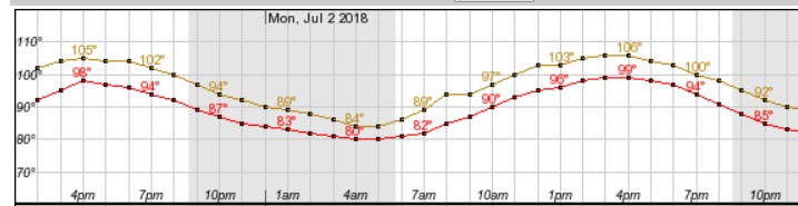
The heat index on Monday was set to peak at 2 p.m. in Baltimore at 105 degrees, according to the National Weather Service.
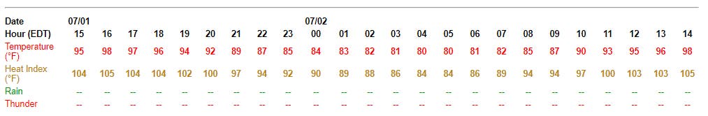
Temperatures will be at or above 100 degrees on the heat index from 11 a.m. to 7 p.m. on Monday, with the hottest temperatures between 2 and 6 p.m.
The National Weather Service gave this timeline of temperatures for Baltimore on Monday, July 2; the yellow line is heat index and the red is for the actual temperature:
To avoid becoming ill, people should reschedule strenuous activities to the early morning or evening; drink water; and wear light, loose-fitting clothing. Those working outside should take frequent breaks in shade or air-conditioning.
Here are several ways to stay safe during the heat advisory period:
- Lighten up. Wear lightweight, light-colored clothing. Light colors reflect away some of the sun's energy. It is also a good idea to wear hats or to use an umbrella.
- Drink water. Carry water or juice with you and drink continuously even if you don't feel thirsty. Avoid alcohol and caffeine, which dehydrate the body. Avoid salt tablets unless directed by a physician.
- Eat small meals and eat more often. Avoid high-protein foods, which increase metabolic heat.
- Slow down. Avoid strenuous activity. If you must do strenuous activity, do it during the coolest part of the day, which is usually in the morning between 4 and 7 a.m.
- Stay inside. If air-conditioning is not available, go to the lowest floor out of the sunshine. Remember that electric fans do not cool; they simply circulate the air.
- Be a good neighbor. During heat waves, check in on elderly residents in your neighborhood and those who do not have air conditioning.
Heat stroke, the most serious heat-related illness, can be fatal if not treated immediately.
It occurs when the body's temperature rises rapidly and the sweating mechanism fails, leading to overheating without a way to cool down.
Symptoms include confusion; slurred speech; seizures; hot, dry skin or extreme sweating; altered mental status; very high body temperature; and loss of consciousness/coma. If someone exhibits signs of heat-related illness, move the person to a cool, shaded area and call 911.
SEE ALSO: Heat Advisory Issued For Maryland For Sunday
Image via Shutterstock. Table and graph via National Weather Service.
Get more local news delivered straight to your inbox. Sign up for free Patch newsletters and alerts.