Community Corner
Drivers, Use Caution on Roads Tuesday
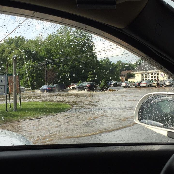
Multiple roads had high water, trees down on Monday.

There was a record amount of rain in Baltimore on Monday, according to the National Weather Service.
The previous record was 2.14 inches on June 1, set in 1979, the weather service reported, and on Monday approximately 2.5 inches were recorded.
Harford County received more than that. County emergency officials said that at 9 p.m., they had recorded 3.44 inches of rain since the morning.
Find out what's happening in Bel Airfor free with the latest updates from Patch.
Several roads in Harford County were impacted by heavy rains and trees down on Monday. The Maryland Transportation Authority said Tuesday drivers should allow for extra braking distance, as roads may still be wet.
The Bel Air forecast for Tuesday calls for a chance of showers all day, with temperatures in the mid 60s, dropping to the upper 50s at night.
Find out what's happening in Bel Airfor free with the latest updates from Patch.
Photo Credit: Sue Sdanowich Saxon. Pictured, US Route 1 at Moores Mill Road on June 1.
Previous report—The National Weather Service has extended the flash flood warning for Harford County until 10:30 p.m. A flash flood warning means flooding is imminent or occurring.
At approximately 9 p.m., Harford County emergency officials said they have recorded 3.44 inches of rain since the morning.
As of 8:45 p.m., Harford County Emergency Management reported there were 13 roads closed for high water or safety reasons:
- Moores Mill Road and Major’s Choice Drive
- Thomas Run Road and Centreville Way
- 300 block of N. Fountain Green Road
- Hickory Avenue at Moores Mill Road
- Belair Road between Milton Avenue and Route 152
- Singer Road and Winters Run Road
- Tollgate between Normandy Lane and Plumtree in the area of Dr. Cooks
- Patterson Mill at Wheel Rd
- Old Joppa Rd at Whittaker Mill
- Route 7 and Route 136—high water
- East MacPhail Road and Glenangus Drive—tree is down
- Rock Spring Church Road between Route 24 and Grafton Shop—tree down
- US Route 1 Bypass past Route 24—tree blocking one lane of traffic
If you see standing water, turn around; don’t drown.
Move to higher ground immediately, and take precautions if living along waterways. Never try to cross swift-moving water or water of unknown depth with a vehicle, weather officials advise.
Previous report—The flash flood warning has been extended until 10:30 p.m. in Harford County. Initially, the flash flood warning was effective from 4:30 to 7:30 p.m. Monday.
By 7:30 p.m., up to 3 inches of rain had fallen in some areas of the county, with more anticipated this evening, according to the weather service.
Harford County Emergency Management says to use caution here:
- Tollgate Road between Normandy Lane and Plumtree Road in the area of Cooks Drive—CLOSED due to high water
- Patterson Mill at Wheel Road—barricades requested for high water.
- Old Joppa Road at Whittaker Mill Road—barricades requested for high water.
- East MacPhail Road and Glenangus Drive—tree is down.
- Cheshire Lane and Dulwich Lane—manhole cover is off.
- Rock Spring Church Road between 24 and Grafton Shop—tree down, no wires, blocking half the roadway.
- Hickory Avenue at Moores Mill Road—CLOSED due to high water.
- Prindle Drive, just off Route 543—manhole cover has come loose.
- 300 block of North Fountain Green Road—high water signs, not shut down yet.
- Scarboro Road between Sandy Hook and Boyd Road—CLOSED due to high water.
- Moores Mill Road and Major’s Choice Drive—CLOSED due to high water.
- Thomas Run Road and Centreville Way— being investigated due to high water.
- Edwards Lane—CLOSED due to high water.
Warning before 5 p.m. Monday—After 4:30 p.m., weather officials said there was 2 inches of rain in northeastern Harford County and 1 to 2 inches near Fallston and Bel Air.
An additional 1 to 4 inches of additional rain are expected in northern Harford and up to 1 inch more may fall near Bel Air, according to the weather service.
These areas may experience flooding, according to the weather service:
- ABERDEEN
- BEL AIR
- RIVERSIDE
- FALLSTON
- PERRYMAN
- BEL AIR SOUTH
- BEL AIR NORTH
- PLEASANT HILLS
- JARRETTSVILLE
- EDGEWOOD
- STREET
- HARFORD FURNACE
- CHROME HILL
- BYNUM
- SCARBORO
- WHITEFORD
- HICKORY
- FOREST HILL
- ABINGDON
- MAGNOLIA
Get more local news delivered straight to your inbox. Sign up for free Patch newsletters and alerts.