Weather
Wind Advisory, Flood Warning Issued For Parts Of MD
Forecasts call for heavy rains, a tornado threat, and 80 mph winds from a powerful storm system set to slam Maryland on Monday.

Updated at 4:15 p.m.
A tornado watch for 16 Maryland counties, plus the city of Baltimore, has been canceled Monday after severe thunderstorms dumped heavy rains on the D.C. region, but that has been replaced in some areas with a flood warning and wind advisory.
Three southbound Interstate 270 lanes in Montgomery County were closed Monday after a band of severe storms pummeled the region with heavy rain. The road closures were in effect on the three southbound right lanes at Tuckerman Lane because of standing water.
Find out what's happening in Ellicott Cityfor free with the latest updates from Patch.
A flood warning is in place until 6:30 p.m. for portions of central Maryland, including Montgomery County. Flooding of rivers, creeks, streams, and other low-lying and flood-prone locations is imminent or occurring, the National Weather Service said. Streams continue to rise due to excess runoff from earlier rainfall. Low-water crossings are inundated with water and may not be passable. Between 1 and 2 inches of rain have fallen.
Another half-inch of rainfall is possible in the warned area.
Find out what's happening in Ellicott Cityfor free with the latest updates from Patch.
Locations that will seee flooding include: Rockville, Bethesda, American Legion Bridge, Potomac, North Bethesda, and North Potomac.
The National Weather Service has issued a wind advisory that is in effect from 8 p.m. to midnight. West winds of 20 to 30 mph with gusts up to 55 mph are expected.
The advisory covers the Washington metropolitan area, northern Virginia, northern, central and southern Maryland. A sudden onset of strong winds are expected behind the cold front this evening.
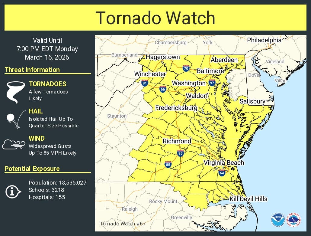
Sixteen Maryland counties, plus the city of Baltimore, were under a tornado watch Monday as a series of severe thunderstorms that could produce heavy rains, and damaging winds with gusts up to 80 mph are forecast to hit the state, forecasters say.
Many school districts in the area have announced plans to dismiss classes early, including Anne Arundel, Montgomery, Prince George's, Howard, Harford and Baltimore counties.
The tornado watch includes these counties:
- Anne Arundel
- Baltimore
- Calvert
- Carroll
- Cecil
- Charles
- Dorchester
- Frederick
- Harford
- Howard
- Montgomery
- Prince Georges
- Somerset
- St. Marys
- Washington
- Wicomico
- Worcester
Severe storms are expected to hit the Baltimore-D.C. area this afternoon, said NBC Washington. The main threat is expected 3 p.m. through 9 p.m., so prepare for potentially dangerous conditions during the afternoon commute.
Damaging winds and tornadoes will be possible. There’s a level 4 out of 5 threat level for severe weather in much of the area.
“This is one of the most elevated severe weather risk days in several years,” Storm Team4 Meteorologist Chuck Bell said.
"Expect multiple rounds of strong to severe storms today with the front crossing this evening. Have a way to get warnings," the National Weather Service said.
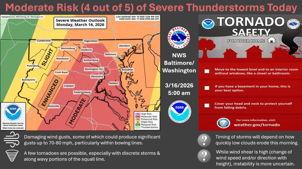
A first round of storms could affect areas west and then north of D.C. between 11 a.m and 1 p.m.; a few could be severe, The Washington Post's Capital Weather Gang said Monday. The greatest concern is a probable line of strong to severe storms between 3 and 6 p.m. capable of producing damaging winds and tornadoes.
Strong storms may continue into the evening, especially east of Interstate 95, with a damaging wind and tornado threat, the Post said. Top wind gusts could hit 80 mph. Rain is expected to wrap up between 8 and 10 p.m., when the system sends temperatures crashing and rain may switch to snow between 10 p.m. and midnight.
"Meteorologists are sounding the alarm for a widespread multiday severe risk stretching across the central and eastern United States from Sunday afternoon into Monday," Accuweather said. "Over a dozen states will be at risk for severe thunderstorms."
As thunderstorms move eastward toward the Eastern Seaboard, so will the risk of severe weather. At least 'some' risk for severe thunderstorms is expected from Florida to New York, the private weather service said. AccuWeather meteorologists have upgraded the risk to high from just north of Baltimore to Columbia, South Carolina.
Commuting Concerns
During the day on Monday, heavy rain and winds could cause problems on roads and airports.
"Downpours reducing visibility and causing ponding on roadways can also impact the [Monday] evening commute," Accuweather said. "Ground stops can also occur at airports throughout the region."
Forecasters also warned that a "March Megastorm" — which is expected to bring blizzard conditions to the Midwest on Monday — will likely impact the Mid-Atlantic and Northeast.
"Wind gusts of 40-60 mph are expected across the central and eastern U.S. Sunday and Monday, from New Mexico to Maine," they say. "These winds alone can create hazardous travel for high-profile vehicles and may bring down tree limbs and power lines, especially in areas already weakened by recent storms."
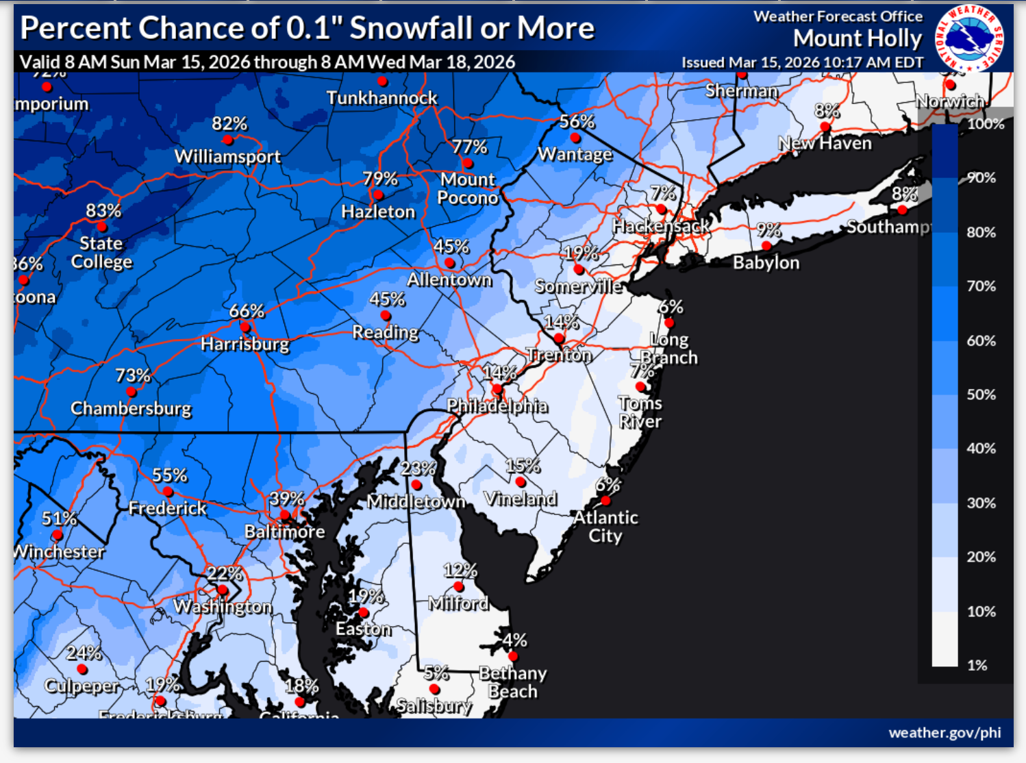
Snow Later
The cold front may lead to snowfall on Monday night as temperatures drop into the upper 20 and low 30s. There's an 80 percent chance of snow in Maryland, but it should only amount to a half inch or less, the NWS says.
Temperatures will fall drastically, with a daytime high of 67 degrees expected on Monday, but only a high of 42 on Tuesday. Daytime highs will reach the mid-50s by the end of the week, according to the National Weather Service.
Here's the Maryland forecast for the week ahead from the National Weather Service:
Monday: Showers and thunderstorms, mainly before 1pm, then showers likely and possibly a thunderstorm after 5pm. Some of the storms could be severe. High near 67. Breezy, with a south wind 10 to 20 mph, with gusts as high as 44 mph. Chance of precipitation is 80%. New rainfall amounts between a quarter and half of an inch possible..
Monday Night: Showers and possibly a thunderstorm before midnight, then a slight chance of showers between midnight and 1am. Some of the storms could be severe and produce heavy rainfall. Low around 32. Breezy, with a south wind 15 to 22 mph becoming west in the evening. Winds could gust as high as 44 mph. Chance of precipitation is 100%. New precipitation amounts between a half and three quarters of an inch possible.
Tuesday: Mostly sunny, with a high near 42. West wind 13 to 15 mph, with gusts as high as 26 mph.
Tuesday Night: Mostly clear, with a low around 27. West wind 5 to 9 mph becoming light northwest after midnight.
Wednesday: Partly sunny, with a high near 41. Calm wind becoming south around 5 mph in the afternoon.
Wednesday Night: Mostly cloudy, with a low around 32.
Thursday: Partly sunny, with a high near 50.
Thursday Night: Mostly cloudy, with a low around 40.
Friday: Mostly sunny, with a high near 60.
Friday Night: Mostly cloudy, with a low around 44.
Saturday: Mostly cloudy, with a high near 60.
Saturday Night: Mostly cloudy, with a low around 43.
Sunday: Partly sunny, with a high near 57.
Get more local news delivered straight to your inbox. Sign up for free Patch newsletters and alerts.