Community Corner
Weekend Weather Looks Frightful: Winter Storm Watch Issued for Baltimore County
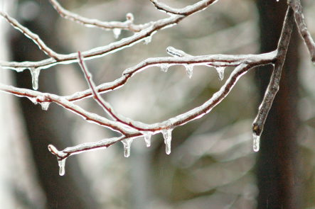
One to two inches of snow and sleet, and a quarter-inch of ice or more may accumulate Sunday night and into Monday.

Written by Jenni Pompi
I hope you enjoyed Thursday's balmy temps, because the next few days in Baltimore County are going to be colder and wetter than a dog's nose.
The National Weather Service is calling for a 80 percent chance of rain Friday, bumping that up to a 100 percent chance overnight. Friday's highs in the 50s will drop to around 37 degrees.
Rain is likely for Saturday morning, though the weather is expected to clear by 10 a.m. Highs should be in the low 40s during the day. Saturday's overnight forecast is dry and cloudy, but temperatures will plummet to 28 degrees.
On Sunday, the Weather Service is calling for a 90 percent chance of precipitation and highs around 35 degrees. Snow is likely before noon, then freezing rain and sleet after 4 p.m. New precipitation amounts between a quarter and half of an inch possible.
A winter storm watch is in effect from Sunday morning through Monday morning, saying snow and sleet will change over to freezing rain Sunday afternoon. The freezing rain is expected to last until Monday morning before changing to rain. One to two inches of snow and sleet, and a quarter-inch of ice or more may accumulate Sunday night and into Monday. Temperatures will be around 31 degrees.
The forecast calls for 1 to 2 inches of snow and sleet in total, with a quarter-inch or more of ice accumulation.
Winter Storm Cleon, the third named winter storm of the 2013-14 season, has already dumped a swath of locally heavy snow from the Rockies to the Upper Midwest, and a stripe of snow, sleet andfreezing rain from the Southern Plains to the Ohio Valley, according to The Weather Channel.
Get more local news delivered straight to your inbox. Sign up for free Patch newsletters and alerts.