Traffic & Transit
Severe Thunderstorms Prompt Ground Stops At DMV Airports
Ground stops are in place for BWI Marshall, Reagan National and Dulles International airports due to incoming severe weather.


All three major airports across Washington, D.C., Maryland and Virginia were under ground stops late into the night Tuesday.
The ground stops were repeatedly extended as late as 11 p.m. as the region was expected to see severe weather.
A National Weather Service advisory had all of D.C. and the majority of Maryland and Northern Virginia under a severe thunderstorm watch through at least 10 p.m.
Find out what's happening in Odenton-Severnfor free with the latest updates from Patch.
.png)
"Damaging wind gusts are the primary threat, although large hail and a tornado are possible," read an alert. "A few instances of flash flooding are also possible."
A flash flood watch was issued for areas along Interstate 64 in central Virginia through 2 a.m. Wednesday.
Find out what's happening in Odenton-Severnfor free with the latest updates from Patch.
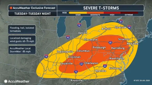
An updated timeline released by officials indicated storms were expected to begin impacting the region between 4 p.m. and 9 p.m., with additional rounds expected to go into the night.
AccuWeather reported that wind gusts could get up to 85 mph, adding that rainfall rates could be 2 inches per hour or more during the worst of the storms.
Detailed Forecast For Greater DC Region
Tuesday Afternoon: Scattered showers and thunderstorms, then showers and possibly a thunderstorm after 5pm. Some of the storms could be severe. High near 91. Heat index values as high as 101. Southwest wind around 13 mph. Chance of precipitation is 80%. New rainfall amounts between a tenth and quarter of an inch, except higher amounts possible in thunderstorms.
Tuesday Night: Showers and possibly a thunderstorm, mainly before 5am, then isolated showers and thunderstorms after 5am. Some of the storms could be severe. Low around 72. Southwest wind 8 to 15 mph, with gusts as high as 20 mph. Chance of precipitation is 80%. New rainfall amounts between a tenth and quarter of an inch, except higher amounts possible in thunderstorms.
Wednesday: A slight chance of showers, then a chance of showers and thunderstorms after 2pm. Partly sunny, with a high near 86. West wind 7 to 11 mph. Chance of precipitation is 50%.
Wednesday Night: A chance of showers and thunderstorms, mainly before 8pm. Mostly cloudy, with a low around 65. North wind around 8 mph. Chance of precipitation is 30%.
Thursday: Mostly sunny, with a high near 81. North wind 8 to 10 mph.
Thursday Night: Partly cloudy, with a low around 64.
Friday: Sunny, with a high near 81.
Friday Night: A slight chance of showers after 2am. Mostly cloudy, with a low around 65. Chance of precipitation is 20%.
Saturday: A slight chance of showers. Partly sunny, with a high near 81. Chance of precipitation is 20%.
Saturday Night: Partly cloudy, with a low around 66.
Sunday: A slight chance of showers and thunderstorms. Mostly sunny, with a high near 87. Chance of precipitation is 20%.
Get more local news delivered straight to your inbox. Sign up for free Patch newsletters and alerts.