Weather
Severe Storms With Tornadoes, 75 MPH Winds, Snow In MD Forecast Monday
Forecasts call for heavy rains, a tornado threat, 75 mph winds and even snow as a powerful storm aims for Maryland on Monday.

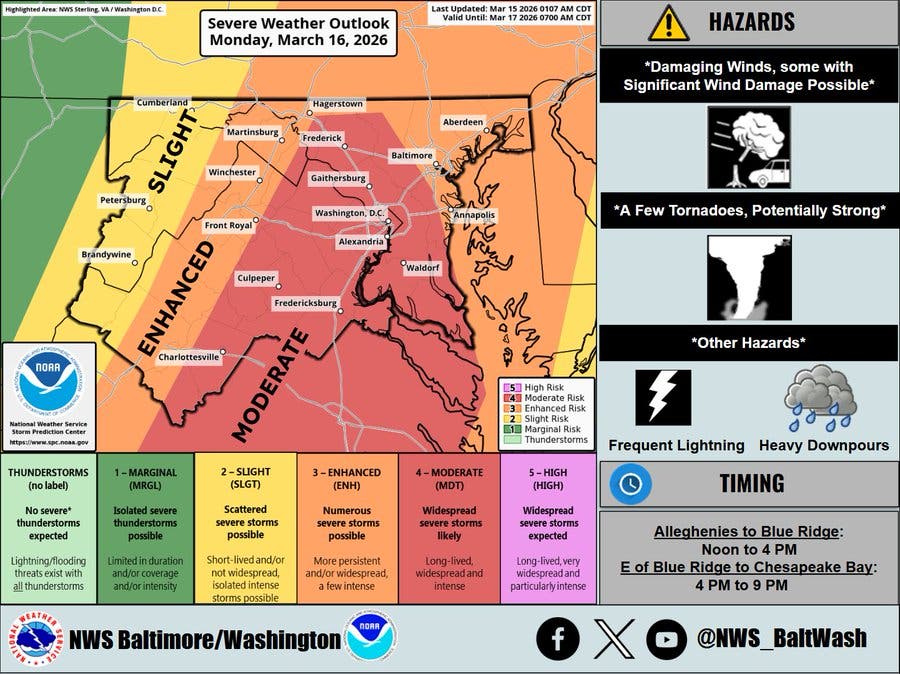
Severe thunderstorms posing a threat of tornadoes, heavy rains, damaging winds with gusts up to 75 mph and an eventual change to snow are all possible Monday as a powerful storm moves into Maryland from Sunday night into Monday, forecasters say.
"Meteorologists are sounding the alarm for a widespread multiday severe risk stretching across the central and eastern United States from Sunday afternoon into Monday," Accuweather said. "Over a dozen states will be at risk for severe thunderstorms."
As thunderstorms move eastward toward the Eastern Seaboard, so will the risk of severe weather. At least 'some' risk for severe thunderstorms is expected from Florida to New York, the private weather service said. AccuWeather meteorologists have upgraded the risk to high from just north of Baltimore to Columbia, South Carolina.
Find out what's happening in Perry Hallfor free with the latest updates from Patch.
Rain will fall overnight into early Monday morning, dumping as much as inch on parts of the state, the National Weather Service said.
"The storms’ timing still needs to be pinned down, but they are most probable between about 1 and 7 p.m. Monday, when an organized and violent squall line is expected to pass," the Washington Post's Capital Weather Gang forecast. "That said, widely scattered showers and storms, some of which could be intense, are possible before this window, as early as 9 or 10 a.m. Rain is expected to linger after the most intense storms pass in the evening."
Find out what's happening in Perry Hallfor free with the latest updates from Patch.
Commuting Concerns
During the day on Monday, heavy rain and winds could cause problems on roads and airports.
"Downpours reducing visibility and causing ponding on roadways can also impact the [Monday] evening commute," Accuweather said. "Ground stops can also occur at airports throughout the region."
Forecasters also warned that a "March Megastorm" — which is expected to bring blizzard conditions to the Midwest on Monday — will likely impact the Mid-Atlantic and Northeast.
"Wind gusts of 40-60 mph are expected across the central and eastern U.S. Sunday and Monday, from New Mexico to Maine," they say. "These winds alone can create hazardous travel for high-profile vehicles and may bring down tree limbs and power lines, especially in areas already weakened by recent storms."
Snow Later
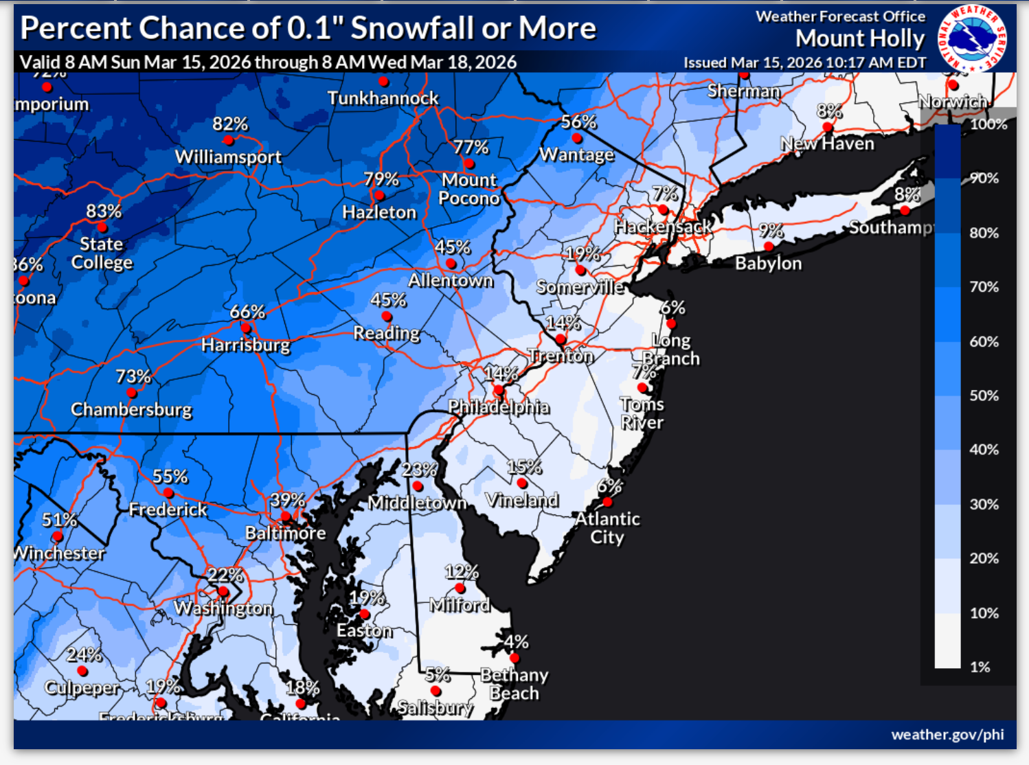
The cold front may lead to snowfall on Monday night as temperatures drop into the upper 20 and low 30s. There's an 80 percent chance of snow in Maryland, but it should only amount to a half inch or less, the NWS says.
Temperatures will fall drastically, with a daytime high of 70 degrees expected on Monday, but only a high of 37 on Tuesday. Daytime highs will reach the mid-50s by the end of the week, according to the National Weather Service.
Here's the Maryland forecast for the week ahead from the National Weather Service:
Sunday Afternoon: Mostly cloudy, with a high near 57. Southeast wind 13 to 15 mph, with gusts as high as 26 mph.
Sunday Night: Showers, mainly before 4am. Low around 51. Southeast wind around 14 mph, with gusts as high as 24 mph. Chance of precipitation is 90%. New precipitation amounts between a tenth and quarter of an inch possible.
Monday: Showers, with thunderstorms also possible after 11am. Some of the storms could be severe. High near 71. South wind 14 to 18 mph, with gusts as high as 36 mph. Chance of precipitation is 100%. New rainfall amounts between a half and three quarters of an inch possible.
Monday Night: Rain showers before 11pm, then rain and snow showers. Some thunder is also possible. Low around 28. West wind 14 to 16 mph, with gusts as high as 32 mph. Chance of precipitation is 80%. New snow accumulation of less than a half inch possible.
Tuesday: Mostly sunny, with a high near 37. West wind 13 to 17 mph, with gusts as high as 32 mph.
Tuesday Night: Mostly clear, with a low around 23.
Wednesday: Partly sunny, with a high near 40.
Wednesday Night: Mostly cloudy, with a low around 30.
Thursday: Partly sunny, with a high near 52.
Thursday Night: Mostly cloudy, with a low around 37.
Friday: Mostly sunny, with a high near 57.
Get more local news delivered straight to your inbox. Sign up for free Patch newsletters and alerts.