Weather
MA Snow Travel Warnings Through Tuesday Night Ahead Of Frigid Blast
A widespread 2 to 4 inches of snow will slow the evening commute with a hard freeze to follow Tuesday night.

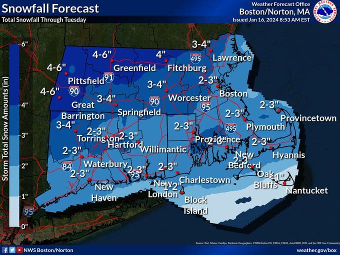
MASSACHUSETTS — A long-duration snow event will drop up to 6 inches of snow across some parts of Massachusetts — with most of the state getting between 2 and 4 inches on Tuesday — before cold air settles in across the region and causes a hard freeze for any spots that mix with rain during the latest storm.
While this bit of winter blast will not compare to recent storms that dropped nearly 20 inches across interior Massachusetts and caused extensive coastal flooding and wind damage, in recent weeks, it will be an issue for those getting back on the roads for both the late morning and evening commutes after a three-day weekend for many.
A Winter Weather Advisory has been issued for much of the state with snow for most of Tuesday morning into early Tuesday afternoon. The National Weather Service is forecasting a switch to sleet and rain for Cape Cod and coastal locations, including Boston, Tuesday afternoon as temperatures rise to about 32 inches, while they remain well below freezing in Worcester, the Merrimack Valley and points north and west.
Find out what's happening in Across Massachusettsfor free with the latest updates from Patch.
See Also:
That will dampen accumulations along the coast where about 1 to 3 inches are expected. A widespread 2 to 4 inches is forecast for Greater Boston, Essex County and much of MetroWest.
Find out what's happening in Across Massachusettsfor free with the latest updates from Patch.
The highest amounts from this storm, as has been the case all winter, will be in the Merrimack Valley, Worcester County and into southern New Hampshire where more than 4 inches could fall — and some areas could hit about 6 inches — because of the "fluff" factor of the snow with colder temperatures.
The good news for this storm is that totals will not threaten double-digits of snow as they did for these areas earlier this month, and there is really no wind or tidal flooding damage to be concerned with before the precipitation clears away Tuesday night.
After that, it will be all about the cold as temperatures settle into highs in the 20s for the rest of the week with a high in the teens likely for a bitter Saturday before temperatures moderate early next week.
There is a chance for a round of snow showers late Friday night into Saturday morning as part of the front that brings to New England that first shot of frigid air this season.
(Scott Souza is a Patch field editor covering Beverly, Danvers, Marblehead, Peabody, Salem and Swampscott. He can be reached at Scott.Souza@Patch.com. X/Twitter: @Scott_Souza.)
Get more local news delivered straight to your inbox. Sign up for free Patch newsletters and alerts.