Weather
Major MA Snowstorm Timeline: Winter Storm Warning In Effect
UPDATE: A Winter Storm Warning was issued for Worcester, Essex and most of Middlesex County for Saturday night's storm on Friday.


Updated 3:30 p.m.
MASSACHUSETTS — Massachusetts residents will be dealing with their first major storm of the season — and for some the first significant snow in two years — this weekend as a mixture of heavy snow, rain and wind marches up the East Coast.
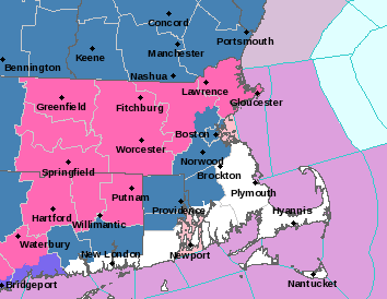
The National Weather Service issued a Winter Storm Warning on Friday for Worcester County and points west, Essex County and most of Middlesex County for the storm beginning late Saturday into Sunday.
Find out what's happening in Across Massachusettsfor free with the latest updates from Patch.
A Winter Storm Watch remained in effect for Greater Boston and most of the rest of the state for late Saturday and Sunday with the exception of southeastern Massachusetts and Cape Cod — where the storm is expected to remain rain the longest but where winds could be up to 50 miles per hour and cause damage.
The weekend will allow for plenty of preparation time on Saturday before the snow and rain move in on Saturday night.
Find out what's happening in Across Massachusettsfor free with the latest updates from Patch.
Here is a weather timeline for those trying to get those last-minute supplies before hunkering down for the storm.
Saturday Day: Those hitting the grocery stores for milk and bread, or the hardware store for shovels and ice melt, will be able to do so on Saturday with a relatively pleasant day on tap. Temperatures will most be in the 30s with some increasing clouds throughout the afternoon.
Saturday Night: While many cities and towns will likely begin to implement snow emergency parking bans at some point late in the day, the storm should have minimal effect on any Saturday night plans — especially early dinners or sporting events.
The current forecast is for the first flakes to begin to fly around 9 p.m. with snow remaining relatively modest through midnight. The storm is expected to start as rain in Boston and along the coast down through Cape Cod.
Overnight Saturday/Early Sunday Morning: Here's where things get interesting as snow ramps up inland and slushy mix batters many Greater Boston communities. Those north and west of Route 128 — especially those north and west of Route 495 — will likely encounter hazardous conditions overnight with those along the coast dealing with an unpleasant mix of wind, rain and wet snow.
Sunday Morning/Early Afternoon: This is when snow is expected to fully spread across the region with the possible exception of the outer Cape and islands. Snow will be fluffier and accumulate faster north and west of Boston with temperatures in the 20s, with cities and towns inside of Route 128 experiencing heavy wet snow with temperatures hovering just below 32 degrees.
Winds will ramp up to 25 mph across the region with higher gusts on the Cape. A combination of high winds and heavy wet snow on power lines could lead to outages in eastern Massachusetts.
Late Sunday Afternoon/Sunday Night: Snow will persist throughout the afternoon before it lightens early Sunday night. Untreated or unplowed roads will remain hazardous. Blustery conditions with temperatures in the 20s will overtake most of the state with winds whipping around to the north at about 20 miles per hour.
Monday: Students looking for an extra long weekend may be out of luck with this one as Monday morning is shaping up to clear with plenty of time for most communities to clear the roads in time for the school buses to roll.
The exception may be some areas in the Worcester Hills and northwest Middlesex County where up to 12 inches of snow will accumulate, and any areas in coastal locations that are still dealing with power outages.
The latest accumulation map from the National Weather Service suggests a large swath of interior Massachusetts getting between 8 and 12 inches of snow with lesser amounts inside of Route 95.
Areas just west of Boston, but inside Route 95, could expect 4 to 6 inches of snow. Immediate coastal locations from Boston north could be looking at 2 to 3 inches of snow with the accumulation coming from late Sunday morning into the afternoon.
Southeastern Massachusetts locations from Plymouth down through Cape Cod and the Islands could get little to snow accumulation — though there may be some at the tail end of the storm as cold air rushes in behind the low-pressure system.
Check back with Patch for local updates and alerts as the first major snowstorm of the season approaches Massachusetts.
(Scott Souza is a Patch field editor covering Beverly, Danvers, Marblehead, Peabody, Salem and Swampscott. He can be reached at Scott.Souza@Patch.com. X/Twitter: @Scott_Souza.)
Get more local news delivered straight to your inbox. Sign up for free Patch newsletters and alerts.