Weather
Tornado Watch Extended To Eastern MA Amid Severe Storm Threat: See Latest Forecast
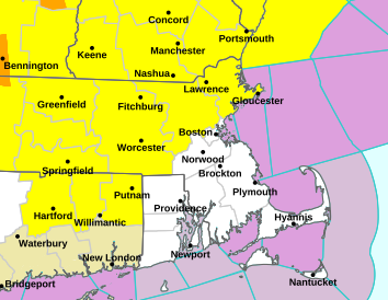
Damaging winds and heavy rain will bring the chance of a tornado across Essex, Middlesex and Worcester counties.


A threat of severe storms with lightning, damaging winds and heavy rains will carry the possibility of a tornado across parts of Massachusetts and New England on Thursday afternoon.
The tornado watch is the first in Massachusetts in nearly two years, according to NBC Boston.
The National Weather Service issued the Tornado Watch for northwest Massachusetts and Vermont early on Thursday and then extended it to include Worcester, Middlesex and Essex counties early Thursday afternoon.
Find out what's happening in Across Massachusettsfor free with the latest updates from Patch.
The tornado watch is in effect until 7 p.m.
The rest of the state is at risk of strong to severe storms developing in the afternoon. Morning rain was to give way to breaks of sun — which would then cause instability in the atmosphere and enhance the chance of storms, according to the National Weather Service.
Find out what's happening in Across Massachusettsfor free with the latest updates from Patch.
MA Beach Closures Spike To 25 Heading Into 3-Day Holiday Weekend
It will be a windy day overall with sustained winds at 20 mph and gusts to 40 mph.
Thursday's rough ride should pave the way for a much nicer long Juneteenth weekend with sunny skies and highs in the 80s on both Friday and Saturday, with the chance of late-day showers on Sunday.
From the National Weather Service:
Thursday
A chance of showers and thunderstorms before 3pm, then showers likely and possibly a thunderstorm between 3pm and 4pm, then a chance of showers and thunderstorms after 4pm. Mostly cloudy, with a high near 80. Breezy, with a south wind 15 to 22 mph, with gusts as high as 39 mph. Chance of precipitation is 60%. New rainfall amounts of less than a tenth of an inch, except higher amounts possible in thunderstorms.
Thursday night
A chance of showers and thunderstorms before 8pm, then a slight chance of showers between 8pm and 9pm. Partly cloudy, with a low around 66. West wind 8 to 16 mph. Chance of precipitation is 30%. New precipitation amounts of less than a tenth of an inch, except higher amounts possible in thunderstorms.
Juneteenth
Mostly sunny, with a high near 84. West wind 11 to 14 mph.
Friday Night
Clear, with a low around 64. West wind around 11 mph.
Saturday
Sunny, with a high near 83. West wind 13 to 15 mph, with gusts as high as 25 mph.
Saturday Night
Mostly clear, with a low around 63. West wind 6 to 9 mph.
Sunday
A chance of showers after 3pm. Mostly sunny, with a high near 83. West wind 6 to 8 mph. Chance of precipitation is 30%.
Sunday Night
A chance of showers before 7pm. Partly cloudy, with a low around 63. Light and variable wind. Chance of precipitation is 30%.
Monday
Showers likely, mainly after 1pm. Mostly cloudy, with a high near 77. Calm wind becoming south 5 to 9 mph in the afternoon. Chance of precipitation is 60%.
Monday Night
Showers likely, mainly before 2am. Mostly cloudy, with a low around 63. East wind around 8 mph becoming northwest after midnight. Chance of precipitation is 60%.
Tuesday
A chance of showers. Partly sunny, with a high near 84. Northwest wind around 9 mph. Chance of precipitation is 30%.
Tuesday Night
Partly cloudy, with a low around 63. West wind 3 to 5 mph.
Wednesday
Sunny, with a high near 86. Light and variable wind becoming northeast 5 to 7 mph in the morning.
Get more local news delivered straight to your inbox. Sign up for free Patch newsletters and alerts.