Weather
Coastal Storm Could Bring 18 Inches Of Snow To Parts Of MA
Rain will turn into a wet, heavy snow, with some parts of the state seeing more than a foot of accumulation.


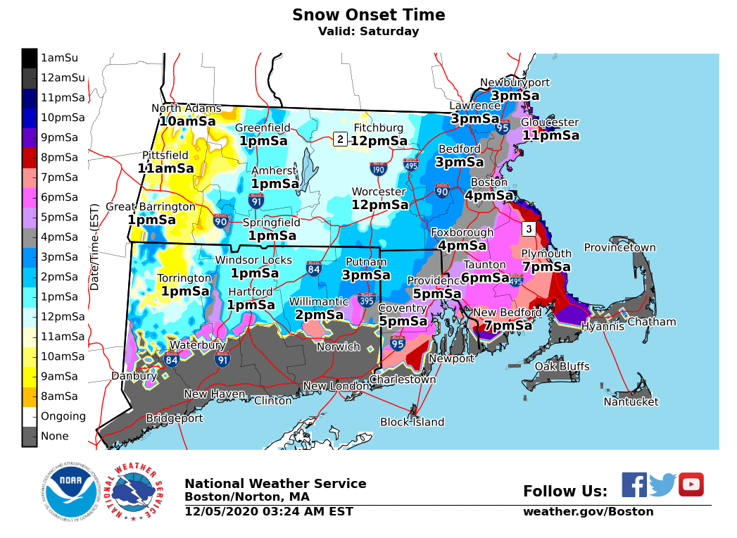
BOSTON — A nasty Nor'easter has taken aim at Southern New England Saturday, with snow totals again upped to more than a foot in parts of the state. What started as a rainy day will turn into snow, leading to messy conditions across the state.
The National Weather Service has continued to raise the expected snow totals in the days leading up to the storm, with Saturday morning's updated forecast showing parts of the state could see as much as 18 inches of accumulation. A winter storm warning is in effect from 1 p.m. Saturday until 7 a.m. Sunday.
Most of the state should see the first flakes fall by early-to-mid afternoon, though the northwest corner of the state could see snow as early as 10 a.m. Worcester is expected to be hit hardest, with a foot to a foot and a half of snow expected.
Find out what's happening in Bostonfor free with the latest updates from Patch.
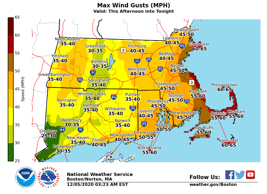
The combination of the wet, heavy snow with high winds could lead to downed trees, power lines and widespread power outages. While the Cape and islands aren't expected to see too much snow accumulation, they'll be hit the hardest by the winds, which could top out at 65 mph in Provincetown. Keep electronic devices charged in case of a power outage.
Boston-area forecast via National Weather Service
Saturday
Rain before 3 p.m., then rain, possibly mixed with snow between 3 p.m. and 4 p.m., then snow after 4 p.m. The snow could be heavy at times. Temperature falling to around 34 by 5 p.m. Breezy, with a north wind 13 to 18 mph increasing to 19 to 24 mph in the afternoon. Winds could gust as high as 48 mph. Chance of precipitation is 100 percent. Total daytime snow accumulation of 2 to 4 inches possible.
Find out what's happening in Bostonfor free with the latest updates from Patch.
Saturday Night
Snow, mainly before 1 a.m. The snow could be heavy at times. Low around 30. Blustery, with a northwest wind 18 to 24 mph, with gusts as high as 48 mph. Chance of precipitation is 100 percent. New snow accumulation of 4 to 6 inches possible.
Sunday
Mostly sunny, with a high near 38. West wind 13 to 17 mph, with gusts as high as 32 mph.
Sunday Night
Mostly clear, with a low around 26. West wind 7 to 10 mph.
Monday
Mostly sunny, with a high near 37. Northwest wind 7 to 9 mph.
Monday Night
Partly cloudy, with a low around 26. North wind 6 to 8 mph.
Tuesday
Mostly sunny, with a high near 36. North wind 8 to 11 mph.
Tuesday Night
Mostly clear, with a low around 24. Northwest wind 6 to 8 mph.
Get more local news delivered straight to your inbox. Sign up for free Patch newsletters and alerts.