Weather
MA Weather: Arctic Blast, Snow To Put Freeze On Spring
Latest Massachusetts weather forecast: It's finally felt like spring the last few days, but a touch of winter could return this weekend.

BOSTON — An arctic blast coming into Massachusetts this weekend is threatening record-setting cold and possibly some snow.
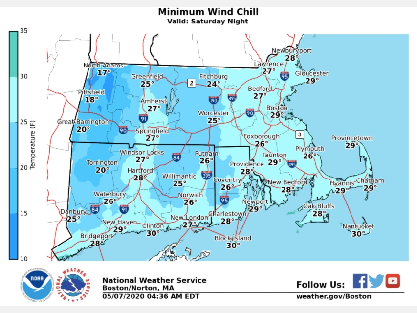
Temperatures are expected to drop to the low 40s and into the 30s Friday night into Saturday morning, according to the National Weather Service. Wind gusts of up to 40-45 miles per hour will introduce wind chills in the 20s.
Snow is expected to fall across much of the state. Most of Massachusetts may only get a dusting, but western Massachusetts could get up to 3 inches. For mid-May, that's 3 inches too much.
Find out what's happening in Bostonfor free with the latest updates from Patch.
The forecast could still change, but for now it appears a temporary freeze on spring. Temperatures are expected to quickly rebound into the high 50s and 60s next week.
>>>Coronavirus Hospitalizations See Largest Single-Day Decrease
Find out what's happening in Bostonfor free with the latest updates from Patch.
[Friday night through Saturday Night] Winter conditions return in May. Accumulating snow likely Fri night over the higher terrain, then blustery and unseasonably cold weather for Sat/Sat night more typical of March. pic.twitter.com/KjqqfebiYR
— NWS Boston (@NWSBoston) May 7, 2020
Boston-area weekend forecast via National Weather Service
Thursday night - A chance of showers, mainly before midnight. Partly cloudy, with a low around 40. Southwest wind 5 to 7 mph. Chance of precipitation is 30 percent.
Friday - A chance of showers, mainly after 5 p.m. Increasing clouds, with a high near 57. West wind 9 to 13 mph, with gusts as high as 23 mph. Chance of precipitation is 30 percent. New precipitation amounts of less than a tenth of an inch possible.
Friday Night - Rain and snow before 4 a.m., then snow likely between 4 a.m. and 5 a.m., then a chance of rain and snow after 5 a.m. Low around 34. Southwest wind 5 to 8 mph becoming north in the evening. Chance of precipitation is 80 percent.
Saturday -A chance of rain and snow showers before 10 a.m., then a chance of rain showers. Mostly cloudy, with a high near 45. Breezy, with a west wind 20 to 24 mph, with gusts as high as 36 mph. Chance of precipitation is 30 percent. New snow accumulation of less than a half inch possible.
Saturday Night - Partly cloudy, with a low around 33. Breezy, with a west wind 13 to 20 mph, with gusts as high as 31 mph.
Sunday - Mostly sunny, with a high near 53. West wind around 15 mph, with gusts as high as 26 mph.
Sunday Night - Partly cloudy, with a low around 39. West wind 5 to 7 mph.
Get more local news delivered straight to your inbox. Sign up for free Patch newsletters and alerts.


