Weather
MA Weather: Timeline Of Tuesday's Downpours
It'll be a close call getting to work before the rain starts, and you may be coming back home during the worst of it.


Morning commuters may get into work before widespread rain falls on the region Tuesday. They won't be coming home in any sunshine, though.
The National Weather Service released "a rough estimate" on the timing of Tuesday's downpours, and it appears at least Eastern Mass. will stay dry until the late morning. The rain is coming in from the west, so Central Mass. will have a closer call.
The rain will last throughout the day. It starts breaking up in the late evening, around 8-10 p.m. The hardest of the rainfall appears to expected during the evening commute, according to the radar approximation below:
Find out what's happening in Bostonfor free with the latest updates from Patch.
[Model Radar Reflectivity] Here's a rough estimate on timing for the rainfall tomorrow. Widespread rain will begin to move in during the morning hours, overspreading the region around noon. NOTE: This is one model of radar reflectivity. This is not meant to be exact. pic.twitter.com/LzfDMOQngJ
— NWS Boston (@NWSBoston) September 24, 2018
Things will get warmer Wednesday, but the weather will stay volatile. A hazardous weather outlook has been issued across most of the state in anticipation of scattered showers and "a few strong t-storms," which the NWS said are expected to move in during the evening.
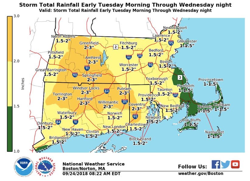
Eastern Mass. could see up to 2 inches of rain from Tuesday morning to Wednesday night. Western Mass. is expected to get hit the hardest, prepping for almost 3 inches. Plymouth County and the Cape will get the least, but still a good drenching.
Find out what's happening in Bostonfor free with the latest updates from Patch.
This week's Boston-area forecast (via NWS)
Monday - Partly sunny, with a high near 57. East wind around 10 mph, with gusts as high as 24 mph.
Monday night - Mostly cloudy, with a low around 46. East wind 5 to 7 mph.
Tuesday - Rain, mainly after 10am. The rain could be heavy at times. High near 64. East wind 6 to 11 mph. Chance of precipitation is 90%. New precipitation amounts between three quarters and one inch possible.
Tuesday night - Rain before 9pm, then showers likely after 9pm. The rain could be heavy at times. Patchy fog after 9pm. Low around 64. South wind 6 to 13 mph. Chance of precipitation is 80%. New precipitation amounts between a half and three quarters of an inch possible.
Wednesday - A chance of showers, with thunderstorms also possible after noon. Patchy fog before noon. Otherwise, mostly cloudy, with a high near 78. South wind 7 to 9 mph, with gusts as high as 25 mph. Chance of precipitation is 50%.
Wednesday night - Showers and thunderstorms likely before 11pm, then a chance of showers. Mostly cloudy, with a low around 58. Chance of precipitation is 60%.
Thursday - Partly sunny, with a high near 66.
Thursday night - Mostly cloudy, with a low around 52.
Friday - Partly sunny, with a high near 66.
Friday night - Partly cloudy, with a low around 52.
Saturday - Sunny, with a high near 68.
Saturday night - Mostly clear, with a low around 51.
Sunday - Mostly sunny, with a high near 66.
Image via NWS
Get more local news delivered straight to your inbox. Sign up for free Patch newsletters and alerts.


