Weather
MA Weather Forecast: Nor'easter Timeline, Snow Totals Detailed
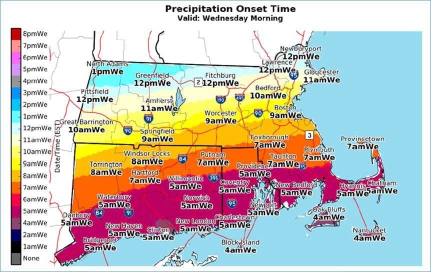
Here's a timeline of Wednesday's storm, which will drop more snow than originally thought.


Happy spring! A fourth nor'easter this month will be landing Wednesday across Southern New England, testing the limits of the Massachusetts psyche when it dumps up to 12-14 inches of snow across the state. Forecasters offered storms specifics in their final forecast Tuesday morning.
The storm is expected to begin Wednesday morning between 5 a.m. - noon, depending on where in the state you are. The farther south the earlier the storm starts. The Boston area can expect the storm around 9 a.m. The snow will be the heaviest Wednesday afternoon into the evening before it begins to taper off early Thursday morning.
The amount of snow pegged to fall has finally been nailed down: The storm is expected to bring between 8-14 inches everywhere east of Springfield, except for the Cape and Islands, which may only see 4-6. (For those who are convinced the "low-end" predictions will finally be realized - that's about 3-5 inches across Eastern Mass. Good luck.)
Find out what's happening in Bostonfor free with the latest updates from Patch.


The Cape will be dealing once again with very strong winds, and power outages will be a concern. The wind gusts will be about 45-55 miles per hour inside the coast and 25-35 mph along it.
Flooding is again a major concern, particularly as Thursday morning's high tide dramatically raises sea levels from Boston to Plymouth.
Find out what's happening in Bostonfor free with the latest updates from Patch.
A coastal flood watch will be in effect along the Cape and a high wind warning will be in effect along the entire coast and Southeastern Mass.
Images via NWS Boston
Get more local news delivered straight to your inbox. Sign up for free Patch newsletters and alerts.