Weather
MA Weather: Rainy Saturday Comes With Warnings
At least some parts of the state could see freezing rain before daybreak, making for dangerously slick roads.

Another storm we likely won't remember but that will be inconvenient all the same is headed our way this weekend. Forecasters are warning of rain throughout Saturday, with a possibility of freezing rain before daybreak that would make the roads dangerously slick.
The National Weather Service has issued a hazardous weather outlook in Central and Western Mass., where the potential for freezing rain is highest. If the forecast takes a turn for the worse, a winter weather advisory could be issued.
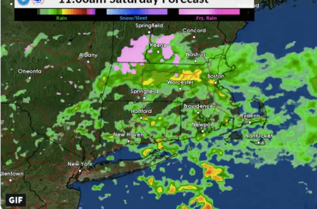
People in Eastern Mass. will still have to deal with a healthy amount of rain through the morning into the afternoon. Then it will fall on and off until it picks up again in the evening as it moves offshore. Below is a possible forecast via the NWS simulated radar.
Find out what's happening in Bostonfor free with the latest updates from Patch.
[Saturday] How will the forecast freezing rain play out? Here's just one forecast model run not to be taken verbatim but rather to illustrate potential trends. Our greatest concern is across the #Berkshires & Worcester Hills for a glaze of ice on untreated surfaces. pic.twitter.com/qJI7Hq0uSl
— NWS Boston (@NWSBoston) January 4, 2019
So when will we be talking snow? No until at least Monday night into Tuesday, when snow could precede rain in a sloppy wintry mix. After that, it's expected to get back to be dry and seasonably cold.
Boston-area forecast via NWS
Find out what's happening in Bostonfor free with the latest updates from Patch.
Friday - - Sunny, with a high near 44. Southwest wind 7 to 9 mph, with gusts as high as 20 mph.
Friday night - Increasing clouds, with a low around 32. Southwest wind 5 to 7 mph becoming calm after midnight.
Saturday - Rain, mainly after 10am. Patchy fog after 4pm. High near 39. Calm wind becoming north around 6 mph in the afternoon. Chance of precipitation is 80%. New precipitation amounts between a quarter and half of an inch possible.
Saturday night - Rain likely, mainly before 11pm. Cloudy during the early evening, then gradual clearing, with a low around 31. North wind around 6 mph becoming west after midnight. Chance of precipitation is 60%. New precipitation amounts between a tenth and quarter of an inch possible.
Sunday - Mostly sunny, with a high near 42. Northwest wind 7 to 13 mph, with gusts as high as 33 mph.
Sunday night - Mostly clear, with a low around 17. Northwest wind 9 to 11 mph, with gusts as high as 29 mph.
Monday - Mostly sunny, with a high near 30. Northwest wind 5 to 9 mph becoming light north in the afternoon.
Monday night - Snow likely, mainly after 10pm. Mostly cloudy, with a low around 23. Calm wind becoming southeast around 5 mph after midnight. Chance of precipitation is 70%.
Tuesday - Snow likely before 10am, then rain and snow likely between 10am and noon, then rain likely after noon. Mostly cloudy, with a high near 40. Southeast wind around 5 mph becoming calm in the morning. Chance of precipitation is 70%.
Tuesday night - A chance of rain and snow before midnight, then a chance of snow between midnight and 4am. Mostly cloudy, with a low around 31. West wind 3 to 5 mph. Chance of precipitation is 30%.
Wednesday - Partly sunny, with a high near 39. Northwest wind around 7 mph.
Wednesday night - Mostly cloudy, with a low around 24. Northwest wind around 7 mph.
Thursday - Partly sunny, with a high near 33. Northwest wind around 7 mph.
NWS Boston image
Get more local news delivered straight to your inbox. Sign up for free Patch newsletters and alerts.


