Weather
MA Weather: Wintry Mix, Strong Winds Picking Up This Weekend
Light snow and freezing rain will start falling tonight, and winds of up to 60 miles per hour will begin tomorrow night into Monday.


A calm start to the weekend will soon give way to a turbulent Sunday and Monday. Forecasters have issued a winter weather advisory and hazardous weather outlook in advance of coming wintry precipitation and blustery winds.
Things begin to get messy overnight Saturday. A wintry mix featuring light snow and freezing ran will move over much of inland Massachusetts after midnight, leaving in the morning. Some may awake to a dusting of snow, and forecasters are warning ice accumulation on the roads. Rain may linger throughout Sunday.
A generally pleasant day gives way to an icy and damp overnight. Here's a rough timing of the precip based on one of our computer models. Thankfully, plenty of time get outdoors if you wish! pic.twitter.com/5rMEYijG8N
— NWS Boston (@NWSBoston) February 23, 2019
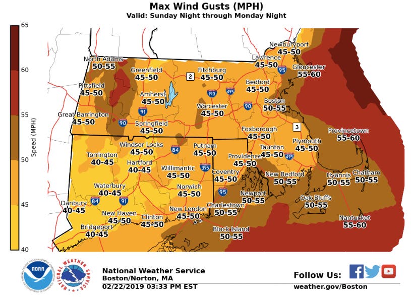
A strong system is coming in Sunday night, though it will be absent the precipitation. Wind gusts are expected to be between 45-60 miles per hour, with the strongest of those coming along the coast. The gusts will peak Monday afternoon, bringing with them the potential for power outages.
Find out what's happening in Bostonfor free with the latest updates from Patch.
Get more local news delivered straight to your inbox. Sign up for free Patch newsletters and alerts.


