Weather
MA Weather: Storms, Heat Today Cap Hottest July On Record
The hottest July on record is ending with a hazardous weather outlook and heat advisory ahead of some volatile evening weather.

Three different weather outlooks and advisories have been called for Massachusetts ahead of volatile weather Wednesday. A heat advisory is in effect for temperatures in the 90s that could feel like triple digits as Boston caps its hottest July on record, while a hazardous weather outlook will accompany scattered thunderstorms across the region this afternoon in the evening. An air quality alert has been called for Western Mass.
The continued heat wave has people at risk for dehydration and heat stroke. Temperatures will be in the mid-90s, but it will feel even more stifling due to humidity. It's par for the course this July: Boston's average temperature entering Wednesday was 78.5 degrees this month, half a degree higher than the previous record. Wednesday is also the 12th 90-degree day in the city this month after zero such days in May or June.
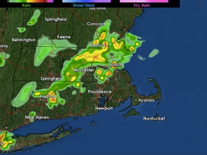
Then come the storms. The National Weather Service said scattered thunderstorms will make their way between 3-8 p.m., intensifying in the early evening. Wind damage, power outages and some flooding in urban areas are possible.
Find out what's happening in Bostonfor free with the latest updates from Patch.
Here's a general idea of the timing of showers & storms this afternoon, mainly between 3 and 8 PM. Be alert for localized wind damage & minor urban flooding! pic.twitter.com/nb0eIa52ib
— NWS Boston (@NWSBoston) July 31, 2019
Boston-area forecast via NWS Boston
Today - A chance of showers and thunderstorms, then showers likely and possibly a thunderstorm after 5pm. Mostly sunny, with a high near 90. Southwest wind 5 to 7 mph. Chance of precipitation is 60%. New rainfall amounts of less than a tenth of an inch, except higher amounts possible in thunderstorms.
Tonight - A chance of showers and thunderstorms. Mostly cloudy, with a low around 68. West wind around 6 mph becoming calm in the evening. Chance of precipitation is 30%. New rainfall amounts of less than a tenth of an inch, except higher amounts possible in thunderstorms.
Find out what's happening in Bostonfor free with the latest updates from Patch.
Thursday - A slight chance of showers. Partly sunny, with a high near 85. North wind 3 to 5 mph. Chance of precipitation is 20%.
Thursday Night - Mostly clear, with a low around 64. Calm wind.
Friday - Mostly sunny, with a high near 84. Light and variable wind.
Friday Night - Partly cloudy, with a low around 64. Light and variable wind.
Saturday - A chance of showers and thunderstorms after 11am. Partly sunny, with a high near 85. Calm wind becoming southwest around 5 mph in the afternoon. Chance of precipitation is 30%.
Saturday Night - Partly cloudy, with a low around 65. Southwest wind 3 to 5 mph.
Sunday - A chance of showers and thunderstorms between noon and 5pm. Mostly sunny, with a high near 85. Light west wind. Chance of precipitation is 30%.
Sunday Night - Partly cloudy, with a low around 62. Calm wind becoming north around 5 mph after midnight.
Monday - Sunny, with a high near 82. Light north wind.
Monday Night - Mostly clear, with a low around 62. Southwest wind 3 to 5 mph.
Tuesday - A chance of showers. Mostly sunny, with a high near 83. South wind 3 to 7 mph. Chance of precipitation is 40%.
Get more local news delivered straight to your inbox. Sign up for free Patch newsletters and alerts.


