Weather
Massachusetts Weather Forecast: Evening Commute Outlook (Yikes)
The slippery, slushy, storm continues throughout the evening.

One of the sloppiest storms of the year will continue through Friday night, mucking up the evening commute. For many, the precipitation will only get worse.
The rate of snowfall is expected to increase to about an inch per hour for everywhere north of the Mass Pike and away from the coast. Everything hinges on how cold it will get, but snow could accumulate on roads from Springfield to south of Boston, the National Weather Service said before 3 p.m. Friday.
The temperatures are most likely to stay just above freezing, especially south of the Pike, where you can expect more of a wintry mix. The temperatures are expected to dip tonight, however, meaning late-night and Saturday morning travel could be impacted.
Find out what's happening in Bostonfor free with the latest updates from Patch.
Check out your commute with our live traffic maps right now! Subscribe and stay updated with your local Patch.
The NWS says the best chance for "prolonged snow" tonight is north of the Pike:
Find out what's happening in Bostonfor free with the latest updates from Patch.
Forecast from one of the hi-res models indicating best chance of prolonged snow through tonight will be north of the Pike. pic.twitter.com/RMJANhDfB1
— NWS Boston (@NWSBoston) March 31, 2017
It looks like the initial higher snowfall estimates may not be realized thanks to temperatures. A big concern going forward will be the intense wind gusts expected overnight into Saturday afternoon. The gusts will threaten 40 miles per hour inland and 50 on the Cape and Islands.

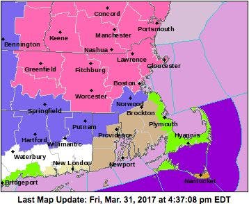
The NWS also expanded warnings throughout the state Friday afternoon. In the map below, pink is a winter storm warning, blue is a winter weather advisory, beige is a wind advisory, green is a coastal flood advisory and orange (we see you, Nantucket) is a high wind warning.
Get more local news delivered straight to your inbox. Sign up for free Patch newsletters and alerts.