Weather
Warmer-Than-Average Temps Recorded In Massachusetts This January
Just three days were below average so far this month, according to the National Weather Service.


January 2020 has been a generally mild month in Massachusetts, according to the National Weather Service. With just a few days left before February, just three days have had colder-than-average temperatures.
The warmest days by far came during the weekend of Jan. 11 and 12, when temperatures were a full 30 degrees of above average. The record-smashing weather was more reminiscent of mid-Junethan the beginning of the year.
The graphic below from the National Weather Service shows the average high and low temperature for each day, with this year's deviation in between. As of Sunday, 23 of 26 recorded temperatures were above average.
Find out what's happening in Bostonfor free with the latest updates from Patch.

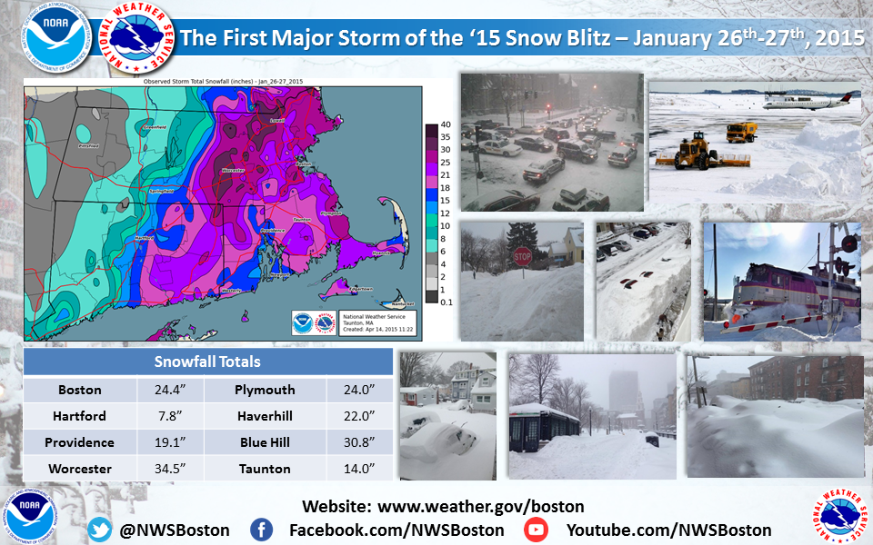
Sunday, which was more than 16 degrees above average, marked the anniversary of a storm that dropped two feet of snow in Boston in 2015 ahead of a six-week "snow blitz" that continued into March, the NWS said.
Here's a look at the latest Boston-area forecast from the National Weather Service.
Find out what's happening in Bostonfor free with the latest updates from Patch.
Tuesday Afternoon
Cloudy, with a high near 40. Northwest wind around 11 mph.
Tuesday Night
Mostly cloudy, with a low around 25. Northwest wind around 9 mph.
Wednesday
Sunny, with a high near 37. Northwest wind around 10 mph.
Wednesday Night
Clear, with a low around 20. North wind 5 to 8 mph.
Thursday
Sunny, with a high near 33. Light and variable wind becoming north around 6 mph.
Thursday Night
Mostly clear, with a low around 24. Calm wind becoming west around 6 mph after midnight.
Friday
Mostly sunny, with a high near 41. West wind around 6 mph.
Friday Night
Partly cloudy, with a low around 29. Light southwest wind.
Saturday
A chance of snow before noon, then a chance of rain. Partly sunny, with a high near 39. Light and variable wind becoming northeast around 6 mph in the afternoon. Chance of precipitation is 30 percent.
Saturday Night
A chance of snow before 3 a.m. Mostly cloudy, with a low around 30. Northeast wind 6 to 8 mph becoming northwest after midnight. Chance of precipitation is 30 percent.
Sunday
Mostly cloudy, with a high near 41. Northwest wind around 9 mph.
Sunday Night
Partly cloudy, with a low around 30. Northwest wind around 9 mph.
Get more local news delivered straight to your inbox. Sign up for free Patch newsletters and alerts.


