Community Corner
UPDATED: Blizzard Warning Issued; 20-30 Inches of Snow Predicted
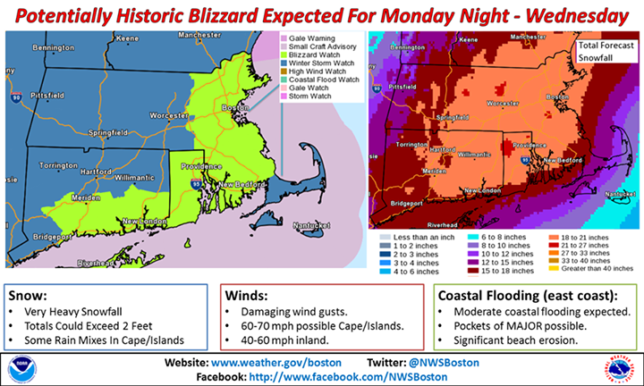
The National Weather Service is calling it a "potentially historic blizzard."

UPDATE at 4:24 p.m. Sunday: The National Weather Service has issued a Blizzard Warning for 7 p.m. Monday until 1 a.m. Wednesday for Eastern and Southeastern Massachusetts and all of Rhode Island.
The NWS is predicting 20 to 30 inches of snow with higher amounts possible. Snowfall rates will be 2 to 4 inches per hour at times during the storm, which the NWS is calling a “potentially historic blizzard.”
The storm is expected to hit late on Monday with the peak of the storm Monday night-Tuesday afternoon.
Find out what's happening in Burlingtonfor free with the latest updates from Patch.
“Heavy snow and strong winds will result in white-out/blizzard conditions with near zero visibility. Travel will be impossible and life-threatening across the entire region,” said the NWS.
Power outages are possible with wet snow expected to bring down tree limbs and wind gusts of around 65 to 75 mph. ”The height of the winds will be late Monday night into Tuesday. The strongest winds will be across the coastal areas,” said the NWS.
Find out what's happening in Burlingtonfor free with the latest updates from Patch.
Original article posted at 7:58 a.m. Sunday:
The National Weather Service is predicting a “potentially historic blizzard” to hit Massachusetts starting on Monday night and stretching into Wednesday.
Eastern Massachusetts and Rhode Island are under a Blizzard Watch and the NWS is predicting some areas may get more than two feet of snow. To put that into perspective, that is more than half of what Boston gets in an average winter.
“Travel may become impossible and life threatening across the entire region. This has the potential to be a historic storm,” said the NWS.
The worst of the storm is expected to be Monday night through Tuesday afternoon. There is a potential for blizzard conditions with zero visibility, said the NWS.
The heavy snow may bring down trees and power lines, which means power outages are possible.
The heavy snow will be accompanied with damaging wind gusts of 40-60 mph inland and 60-70 mph gusts are possible on Cape Cod the Islands. There is moderate coastal flooding expected and pockets of major coastal flooding possible.
7News’ Pete Bouchard said 15-24 inches of snow across the entire region is likely except for the Cape, which will get closer to a foot of snow.
7News said the top snowstorm in Boston on record was 27.5 inches during a storm on Feb. 17-19, 2003.
Bouchard said there could be major flight delays and cancellations and suggested people leave on Sunday or early on Monday if possible.
“Don’t take this one lightly. Tempests like this only come around once in a while. Heed the advice of the authorities and chill out at home,” said Bouchard.
Here are some links to keep handy:
Get more local news delivered straight to your inbox. Sign up for free Patch newsletters and alerts.