Health & Fitness
Blizzard Warning Issued; 1-3 Feet of Snow Predicted
Snowfall rates will be 2 to 4 inches per hour at times. The National Weather Service is calling a "potentially historic blizzard."

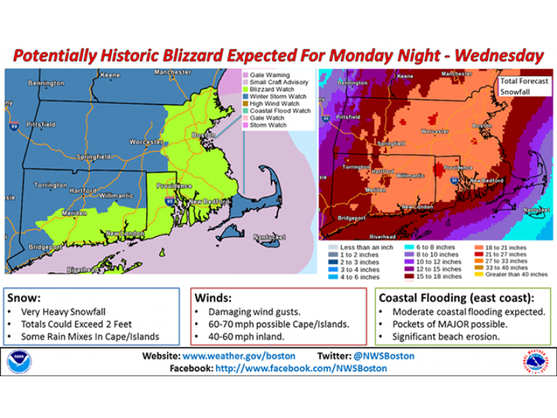
The National Weather Service has issued a Blizzard Warning for 7 p.m. Monday until 1 a.m. Wednesday for Eastern Massachusetts, including MetrpWest and Framingham.
The National Weather Service is predicting 20 to 30 inches of snow with higher amounts possible.
Find out what's happening in Framinghamfor free with the latest updates from Patch.
Snowfall rates will be 2 to 4 inches per hour at times during the storm, which the National Weather Service is calling a “potentially historic blizzard.”
The storm is expected to hit late on Monday with the peak of the storm Monday night-Tuesday afternoon.
Find out what's happening in Framinghamfor free with the latest updates from Patch.
**************************************************************************************
Love Framingham Patch? Sign up for our daily newsletter and breaking news alerts, by clicking here.
**************************************************************************************
“Heavy snow and strong winds will result in white-out/blizzard conditions with near zero visibility. Travel will be impossible and life-threatening across the entire region,” said the Weather Service.
Power outages are possible with wet snow expected to bring down tree limbs and wind gusts of around 65 to 75 mph. ”The height of the winds will be late Monday night into Tuesday.
***
Follow Framingham Patch and its Facebook page and Twitter account for updates on cancellations and other storm news.
Get more local news delivered straight to your inbox. Sign up for free Patch newsletters and alerts.